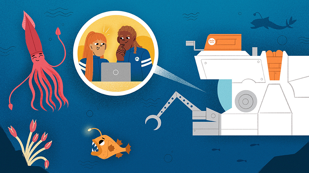
Abstract
From 200 to nearly 11,000 m (about 600–33,000 feet) below sea level and covering two-thirds of our planet, the deep ocean is Earth’s largest—and most critical—habitat. The deep ocean is very important to people for many reasons. For example, it provides foods that we eat, it balances Earth’s climate, and it is a wild unknown space for people to enjoy and explore. Despite its importance, the deep sea is the least explored area on our planet because it is so big, deep, dark, cold, and salty. Researchers need to use special tools such as ships and deep-sea robots to create maps, make new discoveries, and understand how the ocean works and how it affects people and the planet.
Introduction
The deep ocean is the part of the ocean that goes from 200 m below the surface to more than 10,000 m deep (about 650–33,000 feet) and covers two-thirds of the Earth’s surface. The deep ocean is important for many reasons. It provides food for people to eat; it supports plankton, which produce the oxygen that we breathe; it balances Earth’s climate; and it is a wild, unknown space for people to enjoy and explore. The deep ocean is full of amazing life that researchers are just starting to discover and learn about, like mussels that live off the super-hot, chemical-rich waters of hydrothermal vents, bioluminescent animals that glow in the dark, and bacteria that can protect sponges from pollution. The seafloor is a very active environment where scientists find and study volcanoes, earthquakes, landslides, and other hazards that can impact ocean inhabitants and people on land. The deep sea also holds many historical and cultural artifacts, such as shipwrecks, which hold clues to human history.
Even though the deep ocean is very important, this huge volume of water is the least explored space on our planet because it is very difficult and expensive to study. Some of the challenges with studying the deep seafloor are:
• The deep sea is, of course, deep! The force of water can crush anything that goes down to great depths (Figure 1).
• Sunlight cannot travel beyond about 200 m of water, so it is very dark in the deep ocean. Researchers need to bring lights down to illuminate the seafloor. Even then, they cannot see very far—it is like using a flashlight in a snowstorm at night.
• Most of the water at the bottom of the ocean is nearly freezing (around 4°C/39°F), but some can be hundreds of degrees, like the water near volcanoes and hydrothermal vents. Scientists must use special materials so their tools do not freeze, burn, or melt.
• Ocean water contains salt and other minerals that can make some metals rust.
• The ocean is very big. Many research vessels can only travel 11–14 mph, slower than driving in a neighborhood. It takes a long time to travel to and from remote areas.
• The tools needed to explore and study the deep seafloor can cost a lot—even millions of dollars. Many scientists cannot afford to buy and maintain these tools.
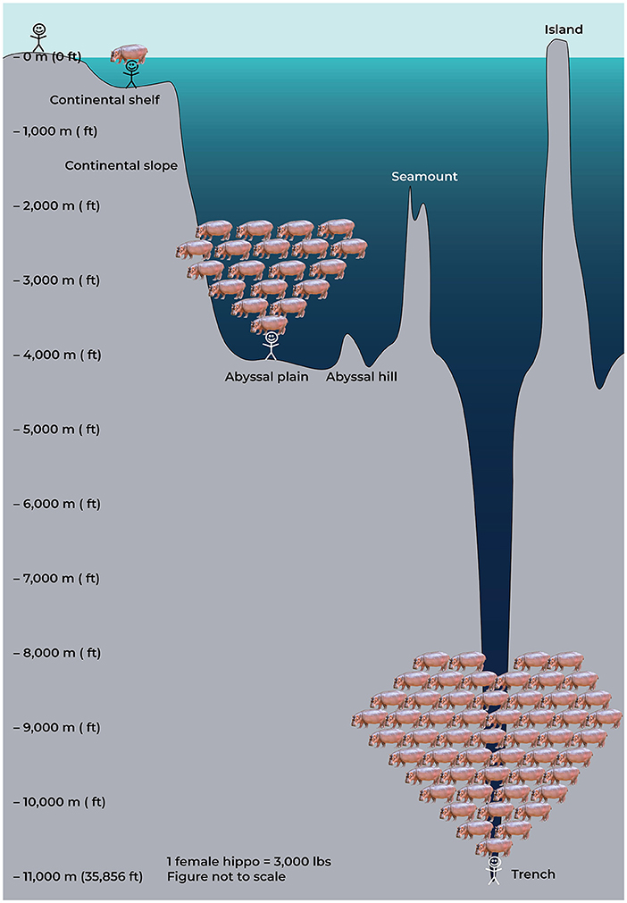
- Figure 1 - We can compare the pressure of the water to what it would feel like to have hippos standing on your head.
- There is no water pressure on land, so it feels like no hippos are on your head. At 200 m water depth, it would feel like one hippo was standing on your head. At 4,000 m (the ocean’s average depth), it would feel like 19 hippos were on your head. In the deepest ocean trenches (~11,000 m), it would feel like 53 hippos were standing on your head! To explore the ocean at this depth, equipment must be specially designed to withstand this crushing pressure.
Because of these challenges, oceanographers need to invent and use many kinds of specialized tools, like research vessels and underwater robots, to create maps of the seafloor and make new discoveries, so they can understand and protect the deep-sea environment.
Gathering Data From the Deep Ocean
When preparing to explore a new part of the ocean, oceanographers must gather as much information as they can about that place. First, they go to the library or use the internet to find and read as much as possible about the area and learn if any work has been done there before. This can include reading publications, talking to people who live in the area, finding maps, or learning about local weather patterns. They also research the best types of tools to use in the area and depth they plan to explore. Once they have gathered all the information possible, they meet the ship and head out to sea.
Seafloor Mapping
The next step is to make a good map of the new area. The best tool oceanographers have today is a multibeam echo-sounder, which is attached to the bottom of a ship or underwater vehicle and uses sound to measure the seafloor’s depth (Figure 2A). A multibeam echo-sounder sends a line of signals, or “pings” through the water. We record the time it takes for the signals to bounce off the seafloor and return to the echo-sounder, then we calculate the depth of the water using that time and the speed of sound in water (1,500 m/s). By sending a line of pings as the ship or vehicle travels through the water, we can create a bathymetric seafloor map.
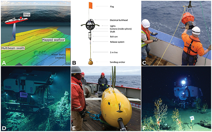
- Figure 2
- (A) A ship travels back and forth like a lawn mower, to gather mapping data with a multibeam echo-sounder. (B) Landers like the National Geographic Deep-Sea Camera System have been used to study biodiversity worldwide [1]. (C) Deep Argo floats are drifters that measure temperature and salinity in the ocean worldwide [2]. (D) ROV Deep Discoverer illuminates boulders covered in bamboo corals in the North Atlantic Ocean (© NOAA Ocean Exploration). (E) AUV Boaty McBoatface sits on deck after collecting important deep-sea climate data in the Southern Ocean (© Povl Abrahamsen, British Antarctic Survey) [3] (F) Scientists used HOV Alvin to study the impacts of the 2010 oil spill on the deep-sea corals in the Gulf of Mexico (© ECOGIG).
Some multibeam echo-sounders can also tell if the seafloor is soft or hard, or if bubbles (or even fish!) are in the water. All of this information helps scientists understand more about a new area, and it helps them plan what they want to do next. For example, if multibeam echo-sounder data show that the seafloor is shaped like a cone, has hard sides, and has bubbles coming up in the middle, it might be a new underwater volcano discovery! But we need other tools to directly observe what we think is there.
Tools for Visual Observations
To check their new maps and make direct observations of the seafloor, oceanographers can use different types of deep submergence vehicles (DSVs; Figure 2). Some of these tools include:
• Landers: landers are underwater vehicles that are dropped to the seafloor, collect information, and rise back up to the surface (Figure 2B) [1]. Landers can be small, inexpensive, and easy to deploy but can only “see” one point on the seafloor at a time.
• Drifters and gliders: these underwater vehicles can drift or glide a certain distance above the seafloor (Figure 2C). Drifters collect data for a certain amount of time or over a certain distance, then rise back up to the surface for a scientist to collect it. Drifters can be small or large, and they are more expensive to buy and use than landers, but they can “see” more of the seafloor.
• Remotely operated vehicles (ROVs): ROVs are robotic vehicles with a cable (also called a tether) connecting them to the surface (Figure 2D). They are driven or “flown” by ROV pilots on a ship. The people on the ship can see the data in “real-time”—while the information is being collected by the ROV. Deep-sea ROVs need a large ship to deploy them, and they are expensive to buy and operate. Since people are not inside the ROV and it is powered by the ship, it can stay on the seafloor for days.
• Autonomous underwater vehicles (AUVs): AUVs are robotic vehicles programmed to carry out a mission over a certain area (Figure 2E). AUVs do not have a tether to the ship, so they can cover more area than other types of vehicles, but scientists cannot see the data in real-time. Deep-sea AUVs can be deployed from a ship or from shore, and they can operate for days. Large AUVs can be expensive to buy and operate.
• Human-occupied vehicles (HOVs): HOVs are submarines with one to three scientists and engineers inside, and they do not have a tether to the ship (Figure 2F). Because they have humans onboard, HOV missions are no longer than a few hours. HOVs need a large ship to deploy them, and they are very expensive to buy and operate.
All types of DSVs can have various sensors to collect different types of data or information about the environment. The most common data types collected on the seafloor are videos and photos, as well as measurements of depth, temperature, and salinity (saltiness). ROVs and HOVs can also have robotic arms to collect samples of rocks or living things from the seafloor.
Discoveries in the Deep Sea
The data collected by ships and underwater vehicles are then used to make new discoveries about Earth’s ocean (Figure 3). For example, more than 5,000 new deep-sea species were discovered in the Clarion-Clipperton Zone, which stretches 4,500 miles from south of Hawai’i almost to Mexico in the Pacific Ocean (Figures 3A, B) [4]. These animals could be under threat from deep-sea mining. Another example is the famous HMS Endurance, discovered in 2022 in the freezing seas of Antarctica (Figure 3C). The ship was trapped and crushed by sea ice (incredibly, all crew survived!), and it is an important story in the history of polar exploration. Yet another deep-sea discovery involved finding a new habitat created by a landslide on the slope of the Kick’em Jenny underwater volcano, off the coast of Grenada in the southeast Caribbean Sea (Figure 3D) [5]. This habitat contained the world’s largest known mussels that live off the chemical-rich water being squeezed out of the seafloor.
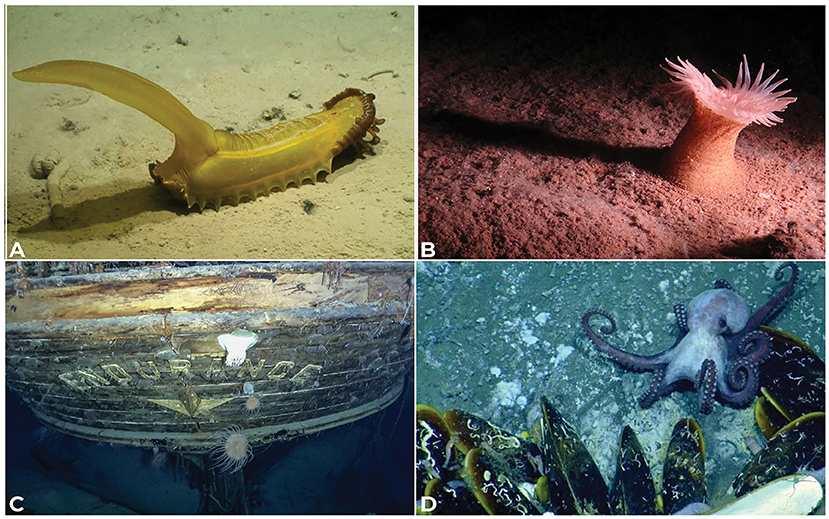
- Figure 3 - Thousands of new creatures were discovered in the Clarion-Clipperton Zone, including (A) a gummy squirrel, a type of sea cucumber that can be 15–30 cm long, and (B) a new species of anemone, approximately 10 cm across.
- These animals are at risk from deep-sea mining. (© NOAA Ocean Exploration & Smartex Project/NERC). (C) The wreck of HMS Endurance was found 107 years after it sank. (© Falklands Maritime Heritage Trust & National Geographic). (D) Co-author Katy Croff Bell co-led the team that discovered a new habitat on the side of an underwater volcano in the Caribbean Sea. Some of the largest known mussels in the world were discovered-longer than 34 cm. (© Nautilus Live).
Future of Deep-Sea Exploration
Because of the vast size of the deep ocean, its many challenges, and the high cost of deep-sea exploration, oceanographers have explored less than 0.002% of the deep seafloor in the last 60 years. If we keep going at that rate, it will take more than a million years to see the entire deep seafloor! The world needs inventors and explorers to help build more tools that can cover more area, are easier to use, and are less expensive, so scientists can more quickly discover and protect the deep sea’s amazing mysteries.
Glossary
Hydrothermal Vents: ↑ Places where water comes up through cracks in the seafloor after it has been heated and enriched in metals and other chemicals by magma under the seabed.
Bioluminescent: ↑ The word to describe living creatures that emit light.
Oceanographers: ↑ Scientists who study the ocean.
Multibeam Echo-Sounder: ↑ An instrument that uses multiple beams of sound to determine the water depth below the surface using sound waves.
Bathymetric: ↑ “Bathy” means deep, and “metric” means measure, so this term means the measurement of the seafloor’s depth.
Deep Submergence Vehicles: ↑ Robotic underwater vehicles that are used to explore and study the ocean.
Sensors: ↑ Devices that are used to measure and record information about the environment, such as temperature or depth.
Conflict of Interest
The authors declare that the research was conducted in the absence of any commercial or financial relationships that could be construed as a potential conflict of interest.
References
[1] ↑ Giddens, J., Turchik, A., Goodell, W., Rodriguez, M., and Delaney, D. 2021. The National Geographic Society deep-sea camera system: a low-cost remote video survey instrument to advance biodiversity observation in the deep ocean. Front. Mar. Sci. 7:601411. doi: 10.3389/fmars.2020.601411
[2] ↑ Johnson, G., and Lyman, J. 2014. Where’s the heat? Nat. Clim Change 4:956–7. doi: 10.1038/nclimate2409
[3] ↑ Kennedy, M. 2019. Boaty McBoatface, Internet-Adored Sub, Makes Deep-Sea Discovery on Climate Change. NPR. Available online at: https://www.npr.org/2019/06/18/733759839/boaty-mcboatface-internet-adored-sub-makes-deep-sea-discovery-on-climate-change
[4] ↑ Rabone, M., Wiehase, J. H., Simon-Lledó, E., Emery, A. M., Jones, D. O. B., Dahlgren, T. G., et al. 2023. How many metazoan species live in the world’s largest mineral exploration region? Curr. Biol. 33:2383–96.e5. doi: 10.1016/j.cub.2023.04.052
[5] ↑ Carey, S. N., Ballard, R., Bell, K. L. C., Bell, R. J., Connally, P., Dondin, F., et al. 2014. Cold seeps associated with a submarine debris avalanche deposit at Kick’em Jenny volcano, Grenada (Lesser Antilles). Deep-Sea Res. 93:156–60. doi: 10.1016/j.dsr.2014.08.002