
Abstract
Have you ever wondered how scientists know what is happening deep below the surface of the ocean? There are several types of robots that can dive below the sea surface and bring back data from underwater. One type of robot, called an Argo float, moves through the middle depths of the ocean with the currents and comes to the surface once every 10 days, to tell scientists about the information that it has collected. Currently, there are about 4,000 Argo robots keeping an eye on Earth’s oceans every day. These robots measure ocean temperature and saltiness, and some can also monitor more complex chemical and biological parameters. Argo robots provide another tool in an oceanographer’s toolbox, to help scientists understand how the ocean works and how it impacts not only marine life, but also the whole Earth.
Why Are Scientists Keeping an Eye on Earth’s Oceans?
The ocean is very important to human wellbeing because it provides us with food, medicines, transportation, and recreation. The ocean is also home to many marine (ocean) species that make Earth friendly to humans. For example, the small plankton in the ocean produce more than 50% of the oxygen that we breathe. The ocean makes up more than 70% of Earth’s surface area and plays a major role in the planet’s environment. For all these reasons, scientists have known for many years that it is essential to observe the ocean, to better understand it and to predict the changes that may happen.
Scientists who study the atmosphere are also interested in observations of the ocean because the weather we experience every day is influenced by the ocean. For example, have you ever seen water evaporating from a hot road? The same thing happens in the ocean, when warm sea surface temperatures cause evaporation, which transfers water from the ocean to the atmosphere. Once in the atmosphere, the water helps to form clouds, snow, and rain. So, better monitoring of ocean conditions results in better weather forecasts.
Some scientists are specialists in studying Earth’s climate. Regions with a “tropical climate” get a lot of sunlight each year. That makes the sea surface warm and produces clouds and rain, so the climate in these regions is typically hot and humid. But the climate can change over time. For example, some human activities, such as driving cars or heating our homes, can add greenhouse gasses to the atmosphere. Greenhouse gasses act like a blanket, trapping heat and warming Earth’s surface. Ocean observations are important for understanding how greenhouse gasses are contributing to climate change because the ocean can absorb carbon dioxide and heat from Earth’s atmosphere and move them around via ocean currents.
Argo Robots: Free-Roaming Ocean Adventurers!
To study the ocean, scientists must consistently collect data for many years. One important way to get this information is to go on ships to take measurements (See also this Frontiers for Young Minds article). But there are places that are difficult for ships to get to, such as the Arctic and the Antarctic. Winters also produce rough seas that are difficult for ships to operate in. To collect measurements from Earth’s oceans in all seasons, scientists invented Argo robots (Figure 1).
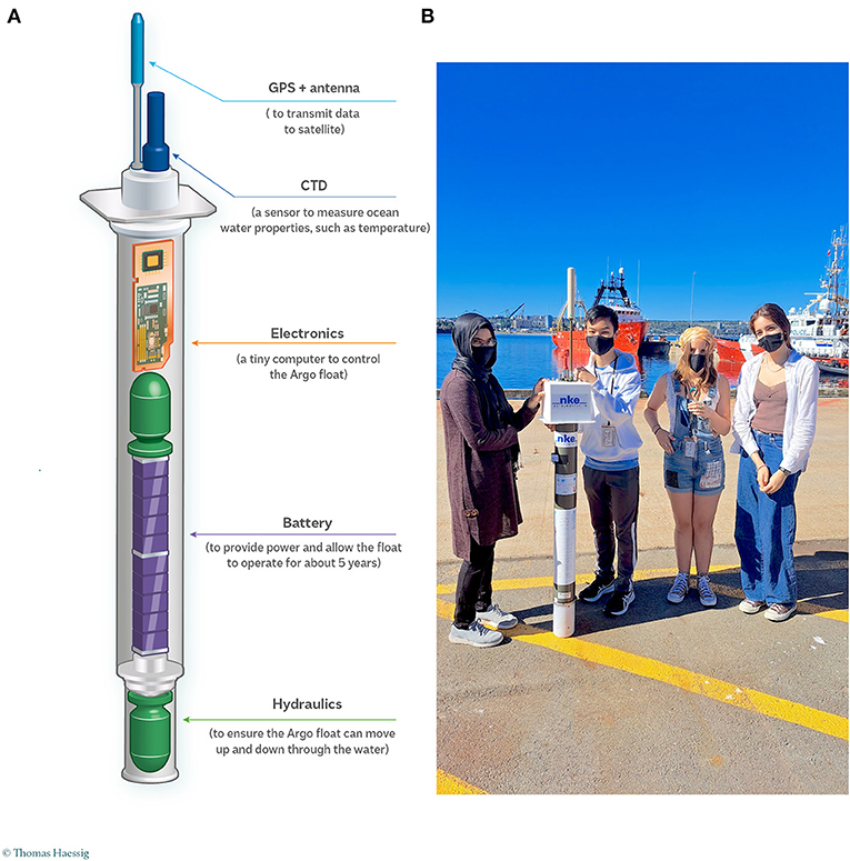
- Figure 1 - (A) A drawing showing the main components of an Argo robot (Image credit: © Thomas Haessig).
- (B) A group of high school students with an Argo robot. These students were participating in the development of the Adopt-a-float program in Canada.
These Argo robots are called “floats,” and they carry sensors to collect ocean data. Even though we call these robots “floats,” they actually go up and down in the ocean. Scientists put Argo robots into the ocean from ships. Once they are in the ocean, they sink to 1,000 m and move freely with the ocean currents at that depth for 9 days. On the 10th day, they dive to 2,000 m, then rise to the surface, taking ocean measurements on their way up. When they reach the surface, they send the data they collected and their location back to the scientists via satellites, thus enabling scientists to build a database of information about this part of the ocean. After that, they dive back to 1,000 m and start the cycle over again (Figure 2A). Scientists use computer programs to check the measurement quality and transfer the information to a database (Figure 2B). The measurements are freely available to everyone within 24 h of the robots surfacing (Figure 2C).
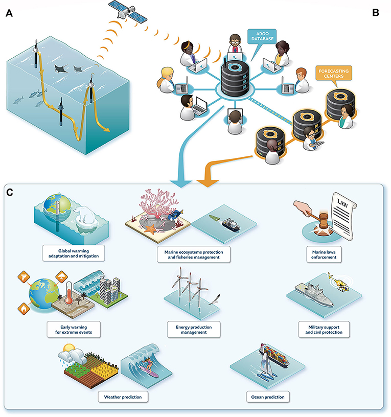
- Figure 2 - (A) An Argo float drifts with ocean currents 1,000 m below the surface.
- Every 10 days it sinks to 2,000 m and then rises to the surface, collecting ocean data on its way up. At the surface, it connects to a satellite and sends the information it has collected to science teams around the world. (B) The information is stored in a database for everyone to use, and it helps to improve local weather forecasts. (C) There are many applications of Argo data that improve our daily lives (Figure credit: © Thomas Haessig).
Argo robots record pressure, temperature and salinity measurements. Salinity is a measure of the concentration of salt in the ocean. Salinity and temperature together determine the density of seawater. Pressure tells the scientists the depth at which the temperature and salinity measurements are taken. In the ocean, one meter (m) in depth is about the same as one decibar (dbar) in pressure. In the atmosphere, high and low pressures create our weather systems. In the ocean, high and low density areas create currents, which move large amounts of water around the globe. Understanding how water moves around in the ocean is important for research on climate, as well as for protecting the plants and animals that live in the ocean.
When scientists first designed the network of Argo robots in the late 1990s, they wanted the data to complement sea surface height measurements collected by a satellite named Jason. In Greek mythology, Jason sailed on a ship named Argo, searching for the golden fleece. Therefore, the ocean scientists called these robots Argo floats. Sea surface height data from satellites can be combined with Argo data to inform scientists about changes in ocean currents. The Argo robots have been roaming the ocean for the past 20 years and have collected over 2 million measurements around the world [1]. Today there are almost 4,000 Argo robots collecting ocean measurements.
Argo robots are powered by batteries and work around the clock every day of the year. Because of these robots, scientists can now keep an eye on Earth’s oceans like never before. The batteries in Argo robots usually last more than five years. When the batteries are used up, these robots will become inactive and sink to the ocean bottom. While this may seem like littering the ocean, the environmental impact on the ocean is extremely small compared to other pollutants, and the ocean data collected is extremely valuable for understanding Earth.
What Can Argo Robots Tell Us About the Ocean?
Since 1970, the ocean has taken up more than 90% of the heat created by greenhouse gasses from human activities. Temperatures in many areas of the world’s oceans have increased. One way that scientists monitor this is by using temperature and salinity measurements to calculate how much heat has been added to a layer of the ocean, called ocean heat content (Figure 3). By using data collected by Argo robots, scientists have discovered that extreme events like heat waves are occurring more often in the ocean, just as they are in the atmosphere. These marine heat waves cause marine animals to move to other areas to find cooler water. However, plants and animals that cannot move will suffer from these marine heatwaves.
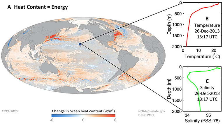
- Figure 3 - (A) Change in ocean heat content in the upper 700 m of the ocean from 1993–2020.
- Heat content is a measure of energy and is calculated from temperature and salinity. Between 1993–2019, ocean heat content rose by up to 6 Watts per square meter in parts of the ocean (dark red). Some areas lost heat (blue), but overall, the ocean gained more heat than it lost. (B) Example temperature and (C) salinity measurements from an Argo robot near Hawaii, reported on December 26, 2013.
Global sea level rise is another big consequence of climate change. As the water in the ocean warms, it also expands, which is one of the main causes of sea level rise. A rising sea level can have dramatic impacts in our daily lives because it can cause flooding, erosion, and make freshwater undrinkable due to mixing with salty seawater (See this Frontiers for Young Minds article for more information on sea level rise). Argo robots are a key tool in monitoring global sea level rise because they keep an eye on how Earth’s oceans are changing.
Keeping track of the ocean has also led to improvements in weather forecasting. Using the temperature and salinity data sent back by Argo robots, scientists have added a computer model of the ocean to their weather forecast calculations. Having real ocean data in these models improves scientists’ understanding of how the atmosphere and the ocean interact with one another. This is very important for predicting intense storms like hurricanes, cyclones, and typhoons, which gain a lot of their strength from warm ocean surfaces.
Going Deeper and in New Directions
In the past, Argo robots were restricted to the top 2,000 m of the ocean, which represents <50% of the global ocean volume. It is very challenging to design robots that can travel to the bottom of the ocean, but scientists and engineers have recently succeeded in making some robots that can dive as deep as 6,000 m [2]. Sampling the ocean from the surface to the bottom will enable scientists to better understand changes in heat and freshwater content, and this will provide better information about global sea level rise.
We are now at the dawn of a new era, in which Argo robots can make measurements related to ocean chemistry and biology [3]. This will provide information on changes in the amounts of oxygen and carbon dioxide in the ocean, for example. The global ocean is currently losing oxygen and absorbing more carbon dioxide from Earth’s atmosphere. These changes are having impacts on the marine ecosystems, including the fisheries that feed many of us.
Argo robots are one tool in an oceanographer’s toolbox. They are part of a global system called the Global Ocean Observing System (GOOS). Together with other partners in GOOS, the advances in Argo robots will help us build a global picture of ocean health and how it is changing over time. You too can join these ocean observers. How? By adopting a float. You can choose an Argo robot, give it a name, and follow its journey around the world. You can also learn more about Argo at the Argo Online School and at Ocean Observers. An ocean adventure awaits!
Glossary
Plankton: ↑ Drifting plants, algae, and some bacteria that can photosynthesize.
Climate: ↑ The description of the long-term pattern of weather in a particular area. This is typically estimated as an average of the data collected (for example, temperature) over at least two decades.
Greenhouse Gasses: ↑ Gases that trap heat in the atmosphere including carbon dioxide, methane, nitrous oxide and fluorinated gases.
Sensors: ↑ A device that detects and responds to some type of input from the physical environment.
Salinity: ↑ A measure of the concentration of salt in the ocean. This can also be referred to as saltiness.
Density: ↑ The amount of matter in a substance (its mass) divided by how much space the substance takes up (its volume).
Ocean Heat Content: ↑ The amount of energy in the form of heat that is stored in the ocean.
Computer Model: ↑ A program that runs on a computer to simulate a real-world system such as Earth’s atmosphere or oceans.
Conflict of Interest
The authors declare that the research was conducted in the absence of any commercial or financial relationships that could be construed as a potential conflict of interest.
Source Article
↑Wong, A. P. S., Wijffels, S. E., Riser, S. C., Pouliquen, S., Hosoda, S., Roemmich, D. et al. 2020. Argo data 1999–2019: two million temperature-salinity profiles and subsurface velocity observations from a global array of profiling Floats. Front. Mar. Sci. 7:700. doi: 10.3389/fmars.2020.00700
References
[1] ↑ Wong, A. P. S., Wijffels, S. E., Riser, S. C., Pouliquen, S., Hosoda, S., Roemmich, D. et al. 2020. Argo data 1999–2019: two million temperature-salinity profiles and subsurface velocity observations from a global array of profiling floats. Front. Mar. Sci. 7:700. doi: 10.3389/fmars.2020.00700
[2] ↑ Roemmich, D., Alford, M. H., Claustre, H., Johnson, K., King, B., Moum, J. et al. 2019. On the future of argo: a global, full-depth, multi-disciplinary array. Front. Mar. Sci. 6:439. doi: 10.3389/fmars.2019.00439
[3] ↑ Bittig, H. C., Maurer, T. L., Plant, J. N., Schmechtig, C., Wong, A. P. S., Claustre, H., et al. 2019: A BGC-argo guide: planning, deployment, data handling and usage. Front. Mar. Sci. 6:502. doi: 10.3389/fmars.2019.00502