Abstract
Salt is a substance with many uses, including as a condiment for our food. Salt is also a rock, and it can be found underground in many places around the world. What makes rock salt fascinating is that, over hundreds to millions of years, it is a rock that flows! Over long periods of time, salt behaves a bit like honey—like a thick, viscous liquid. This means it can change shape faster than other rocks and it can be squeezed to the surface like toothpaste out of a tube. Salt can also flow like ice does in glaciers. Understanding how salt changes shape is important because underground salt is often used to store useful or dangerous substances, such as petroleum or nuclear waste.
Salt: More Than Just A Flavoring
We all know salt in the form of table salt: the white (or light pink) grainy stuff that we add to our food to give it some flavor. This familiar salt flows out of the saltshaker, box, or jar. But that is not the type of flow we will talk about in this article. Rather, we will tell you about salt in the form of a rock. Yes, a rock! You eat ground up rock every day, without even thinking about it! You already know that the grains of table salt are hard—if you take coarse salt grains and squeeze them between your fingers, you will notice that they do not change shape. This is because salt is a solid. But did you know that salt is a solid that can actually flow?
The Origin of Rock Salt
Table salt comes from two sources: salt pans (flat areas) by the sea, where seawater evaporates, leaving the salt behind; or salt mines, where rock salt is extracted from the ground. Salt mines are normally found in areas where rock salt once accumulated naturally, like ancient seas or oceans. This salt was covered by other rocks (such as shale, sandstone, or limestone) and then raised out of the sea by the same tectonic forces that cause mountains to grow. But where does rock salt come from?
Rock salt is an evaporitic rock, which is a rock that is formed by the evaporation of water. As water evaporates, any salts that are dissolved in the water will form crystals. Today, there are many lakes where salt accumulates naturally when sunlight and wind cause the lake water to evaporate. Examples include the Great Salt Lake (in Utah, USA; Figure 1), the Dead Sea (in Israel), Lake Urmia (in Iran), the Salares de Atacama or de Uyuni (in Chile and Bolivia), Lake Assal (in Djibouti), Kati Thanda (in Australia), and many others.
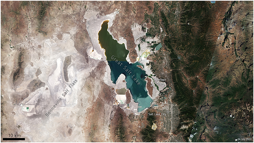
- Figure 1 - Satellite image of the Great Salt Lake in Utah (USA), taken in summer 2022.
- The water has evaporated from the lake and crusts of salt have accumulated around its edges (the whitish and grayish areas). The Great Salt Lake was once part of a much larger lake. Left (west) of the lake, you can see the Bonneville Salt Flats—a salt deposit that formed when waters covering that area evaporated thousands of years ago. Right of the lake (east) you can see Salt Lake City and the mountainous terrain of Utah (Image source: ESA; CC BY-SA 3.0 IGO).
Millions of years ago, before there were humans on the planet, some seas or oceans experienced so much evaporation that salt accumulated in those regions over thousands or even millions of years. This happened in the Mediterranean Sea (5 million years ago), in the Gulf of Mexico (over 150 million years ago), and in the southern part of the Atlantic (over 100 million years ago). When water stopped evaporating and the seas or oceans filled up with water again, sediment (such as mud or sand) formed layers above the salt. Slowly, as the water that was still in the salt was squeezed out by the weight of the overlying sediments, the salt turned into rock salt (and the sediments turned into sedimentary rocks).
As continents get pushed around by tectonic forces, the oceans between them can be squeezed. When that happens, the accumulated layers of sedimentary rock are folded and broken, and they stack up to form mountain chains. All this takes tens of millions of years. At this scale, even rock, that is hard as…well, as hard as rock, can be folded as if it were playdough! Folded rocks are all around us, if we only care to look.
Flowing Salt
What makes rock salt special is that it is much weaker than other types of rock. It is still a rock, so if you punch rock salt with your fist, you will hurt yourself badly. But, over the course of many years, rock salt actually behaves a bit like a viscous fluid—like super thick honey. The rock surrounding rock salt is normally much stronger and cannot deform (change shape) as quickly as salt can. This means that, when piles of rock that contain rock salt have pressure on them (such as when continents move together to form a mountain range), rock salt will deform very quickly—it will flow—while the rest of the rock will still be stiff. Something similar happens with ice: ice is as hard as rock, but if you give it enough time, it flows downhill in the form of glaciers. As ice flows in glaciers, bits of rock or sediment trapped in the ice make all sorts of crazy shapes that track how the ice has flowed. The same happens with salt rock!
In the Gulf of Mexico, the rock salt that formed over 150 million years ago is being squeezed up to the sea surface by the weight of sediments that have been accumulating on top of it for millions of years (Figure 2A). This is similar to what happens when you squeeze a tube of toothpaste. Under all this pressure, the salt flows sideways and upwards and accumulates in what we call salt diapirs. When oceans that contain diapirs are squeezed into a mountain chain, diapirs are squeezed along with the rest of the rocks, and they can continue to deform. If the diapirs are large enough, they can be mined to extract salt that we can use to salt our food! You can even visit some of these salt mines. Our favorites are Zipaquirá (in the Andes of Colombia), Cardona (in the Pyrenees of Spain), Hallstatt (in the Austrian Alps), Wieliczka (in the Polish Carpathians) and Ocnele Mari (in the Romanian Carpathians; Figure 2B).
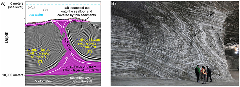
- Figure 2 - (A) A vertical section through a salt diapir (magenta) over 2000 m under the sea, in the Gulf of Mexico.
- The diapir formed when sediments layers (the light and dark gray lines) resting on a thick layer of salt, squeezed the salt sideways and up. Some salt has even flowed onto the seafloor. This diapir is almost 8 km tall—almost as high as Mt. Everest! (B) This photograph was taken inside the Ocnele Mari Mine (in Romania). You can see how the original layers of salt have been folded as the salt flowed [(A) was modified from [1]].
Salt Glaciers: The Namakiers
Salt can flow so easily that it can even form glaciers. Yes, you read that right, glaciers of salt. In the Zagros mountains of Iran, the tectonic forces that continue to move Arabia and Asia together have squeezed out rock salt that was formed more than 500 million years ago! The salt forms diapirs that are about 10 km tall. Some of these diapirs have been squeezed so hard that salt comes out at the surface and flows down the sides of the hills, as if it were ice in a glacier (Figure 3). These salt glaciers are called namakiers (after “namak,” the word for salt in Farsi—the national language of Iran). In namakiers, salt flows at rates of 10–20 cm per year [2]. That is faster than your nails or hair grow! Salt flows even faster when it rains (up to 50 cm per day) because water dissolves some of the salt, making it weaker so that it deforms even faster.
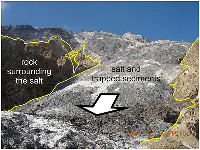
- Figure 3 - A namakier (salt glacier) in Iran.
- The salt is being squeezed out of a diapir in the middle of the mountain (in the background) and is flowing down (in the direction of the arrow), over and around the surrounding sedimentary rocks (behind the yellow lines). The glacier is about 60–70 m meters across, and there is roughly 350 m of elevation difference from the base of the picture to the top (Photograph credit: Jafar Hassanpour).
Why Is This Important?
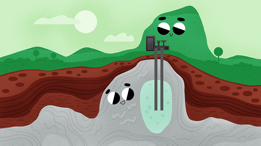
This is all important because we are currently very interested in using rock as a place to store various kinds of materials. Rock salt is an impermeable rock, which means it does not let liquids flow through it—therefore, caverns in salt diapirs are excellent places to store things we do not want to leak out. There are already caverns in salt mines that are used to store petroleum and natural gas that are being kept in the case of shortages. Some countries have also experimented with storing the waste from nuclear power plants in salt mines, to avoid polluting surrounding areas. Additionally, people are currently evaluating the use of salt to store another type of fuel: hydrogen. Hydrogen is a fuel that can be used for transportation or for generating power without polluting the environment, but it can also cause fires or explosions if it comes in contact with air. Underground salt caverns are a perfect place to store hydrogen safely in large amounts.
For storage sites in salt caverns to be safe, we need to be able to predict what will happen to the salt over tens, hundreds, or even thousands of years. We can do this much better if we know how salt deforms over long periods of time. And to do that, the best way we have is by looking at how rock salt has deformed in the past.
Glossary
Tectonic Forces: ↑ Forces that move continents around and, that by pulling them apart and pushing them together, cause the continents and their rocks to deform and form oceans and mountain ranges.
Evaporitic Rock: ↑ Rock that forms when substances dissolved in water are left behind when water evaporates. Salt is the most common evaporitic rock on Earth.
Evaporation: ↑ Process by which water (or another liquid) turns into vapor or gas (as when a puddle of water dries up in the sun).
Dissolved: ↑ Mixed within water (or another liquid). Even if you cannot see dissolved substances floating in water, they can still change the water’s taste and properties.
Sediment: ↑ Mud, sand, and gravel carried by rivers into the oceans, or broken up shells and corals that form a fine mud or sand. Both accumulate in layers under the water.
Sedimentary Rock: ↑ Rock formed by the accumulation of sediments in layers. Limestone, sandstone, and shale are three common types of sedimentary rock.
Diapir: ↑ An underground accumulation of rock salt (or other weak rock material) that cuts up through stiffer sedimentary rocks. Diapirs are taller than they are wide.
Namakier: ↑ A glacier made up almost entirely of rock salt. A namakier is formed when a diapir rises to the Earth’s surface and its salt flows out downhill.
Conflict of Interest
MR is owner and sole employee of Rowan Consulting Inc.
The remaining author declares that the research was conducted in the absence of any commercial or financial relationships that could be construed as a potential conflict of interest.
Acknowledgments
This work was funded by the Project ETAPAS FO999888049 (FFG-Salinen AG, Austria), Project POLARIS I-5399-N (FWF, Austria), and Project SABREM PID2020-117598GB-I00 (MCIN AEI/10.13039/501100011033 Spain) to OF.
References
[1] ↑ Rowan, M. G., Muñoz, J. A., Roca, E., Ferrer, O., Santolaria, P., Granado, P., et al. 2022. Linked detachment folds, thrust faults, and salt diapirs: observations and analog models. J. Struc. Geol. 155:104509. doi: 10.1016/j.jsg.2022.104509
[2] ↑ Talbot, C. J., and Jarvis, R. J. 1984. Age, budget and dynamics of an active salt extrusion in Iran. J. Struc. Geol. 6:521–33. doi: 10.1016/0191-8141(84)90062-2