Abstract
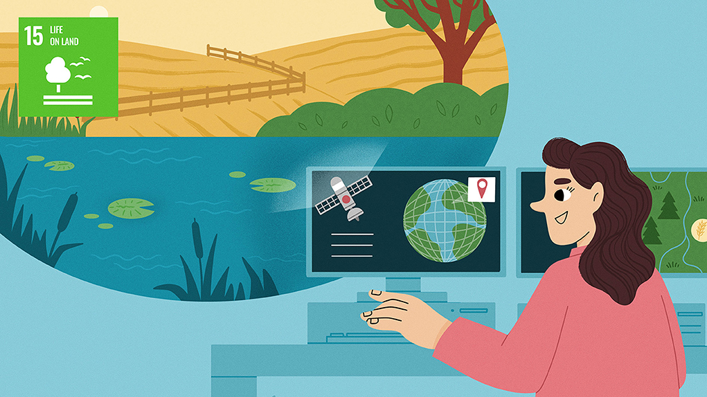
Sustainable Development Goal (SDG) 15, “Life on Land”, is one of the 17 SDGs of the United Nations. SDGs are goals for achieving a better and more sustainable future for everyone. SDG 15 focuses on protecting, restoring and sustainably using land-based ecosystems. Among the many tools scientists can use to achieve SDG 15, remote sensing allows them to capture data from space to monitor and assess land cover and identify when ecosystems are unhealthy. Remote sensing provides valuable information about forests, wetlands and other land-based ecosystems, helping people manage and protect important areas. The fast, accurate data provided by remote sensing can be used by governments to make informed decisions and create policies that will help the world reach SDG 15 targets of protecting life on land.
Watch an interview with the authors of this article to learn even more! (Video 1).
- Watch an interview with the authors of this article to learn even more!
Keeping Land-Based Ecosystems Healthy
The Sustainable Development Goals (SDGs) are a set of 17 global goals set by the United Nations to address the world’s most pressing challenges by 2030, including the elimination of poverty and hunger and ensuring quality education for all. SDG 15, “Life on Land”, is all about protecting and restoring terrestrial (land-based) ecosystems, focusing on forests, wetlands and mountains and making sure they stay healthy. By doing so, we can prevent deforestation, land damage and the loss of plant and animal species. One of the main goals of SDG 15 is to stop endangered species from becoming extinct. This means avoiding practices that harm biodiversity and encouraging sustainable ways of using and conserving our natural resources. SDG 15 also focuses on desertification, the process by which fertile lands are degraded into deserts due to lack of rainfall or bad management of soils. By fighting desertification, land damage and drought, SDG 15 recognizes the importance of the services that ecosystems provide and makes sure ecosystems can support local communities and improve people’s lives.
It is crucial to remember that taking care of terrestrial ecosystems benefits everyone. SDG 15 highlights the significant role that terrestrial ecosystems and biodiversity play in maintaining a healthy planet and supporting the wellbeing of all living things. By sustainably managing the land, we can create an environment that is strong and adaptable for both present and future generations to enjoy.
How Can Science Help?
SDG 15 will not be achieved without science! Science provides creative solutions and helps government officials to make laws to protect the environment. With the help of scientific knowledge, we can identify the most important areas to protect and develop effective strategies to conserve biodiversity. For example, we can identify where endangered species live and keep an eye on their health, planning protection efforts where they are needed most. We can also monitor the movement of populations of wildlife, especially in large areas, helping us to understand animal behaviors and the reasons behind their movements.
Research and monitoring are key components for understanding biodiversity loss, deforestation and land damage. Collecting data on various areas can help to tell us where conservation efforts are most urgently needed, ensuring money and resources are focused on the locations that need the most help. Technology can also make data collection and analysis more efficient, helping us keep track of changes in the environment. Sharing scientific knowledge and teaching others about managing terrestrial ecosystems is also critical—the more scientists, policymakers and communities understand how to improve ecosystems, the better! Overall, incorporating scientific knowledge into sustainable development strategies ensures a better future for our planet and all its inhabitants.
Measuring Land Characteristics From Afar
One of the most important tools for achieving SDG 15 is remote sensing. Remote sensing involves using special systems like satellites and drones to collect data about our planet from afar. These systems can capture pictures, measurements of land elevation and even temperature readings. All these data help us understand terrestrial ecosystems and make decisions based on solid evidence. Images collected by satellites can be used to track land changes over time. We can see things like the types of land cover, characteristics of habitats, the size of forests, the amount of vegetation, the quality of water and even the health of ecosystems. With this information, we can identify areas that are rich in biodiversity, see whether an ecosystem is being damaged, find places that need extra protection and take steps to repair damaged land. Remote sensing can also help us tackle desertification and deforestation. In short, remote sensing gives us a frequent overview of the Earth, to help us understand and manage our land wisely.
Our Research at Kaust
The Hydrology and Land Observation (HALO) group at King Abdullah University of Science and Technology (KAUST) is a team of scientists who use remote sensing to find new solutions for questions related to Earth and environmental sciences. We use various types of cameras to collect images and gain new insights into Earth’s environments and ecosystems, with a particular focus on sustainable resource management and environmental protection—all of which assist the goal of achieving SDG 15. We study various environments, such as mangrove forests along the coast of the Red Sea and agricultural fields in very dry regions (Figure 1). We are developing new methods for analyzing satellite images of mangrove forests to map their distribution and to understand their health and ability to survive [1]. The information we obtain from satellites helps us ensure that these forests are successful. Our research also focuses on precision agriculture, which aims to enhance the efficiency of large-scale food production systems, enabling them to yield more crops using less water and fertilizer [2]. We work on figuring out how much water crops use because agriculture is the biggest consumer of freshwater worldwide. By accurately measuring water use, we can help farmers save water and money. We also collect field measurements, such as soil water content, vegetation density and leaf size; and we use drones to gather detailed information that can help us interpret the satellite images. The exciting part is that we can use satellite images to cover very large areas—even the entire world. This means we can provide valuable information on a bigger scale and in a timely manner. Remote sensing technologies can help us make a positive impact on sustainable land use, agricultural practices and protecting and maintaining the environment.
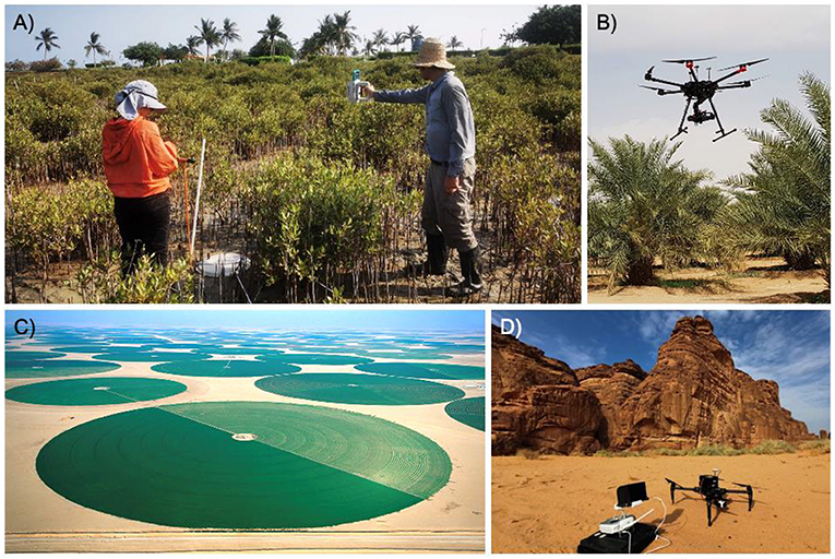
- Figure 1 - Remote sensing allows us to monitor many types of ecosystems.
- (A) Using hand-held sensors, we can measure the optical properties of mangrove forests along the coasts and assess their health. (B, C) Using drones or satellites, we can monitor inland areas with agriculture or (D) nature reserves and mountains. Researchers can combine the data they collect. For example, data from hand-held sensors can be combined with remotely sensed data captured by drones. Combining data helps researchers to better understand and manage ecosystems and expand their knowledge of difficult-to-reach areas of the planet.
The Future… What Can We Do?
Achieving the goals of SDG 15 is difficult, but tools like remote sensing can help us monitor the environment and protect areas that are under threat. To maximize the benefits of remote sensing and reach the goals of SDG 15, countries must work together and share data and information. Technology keeps improving, which means we can capture more detailed information and monitor the environment more frequently. Frequent, detailed data lead to more accurate assessments of the health of terrestrial ecosystems. By using advanced cameras on drones and satellites, we get a more complete picture of the environment (Figure 2). Improvements in data-examination techniques are another exciting development, giving us valuable information from the data we collect. “Near real-time” data processing means that the information from satellites or drones is quickly analyzed and made available shortly after collection. Getting information quickly can help us make better decisions for managing the environment [3].
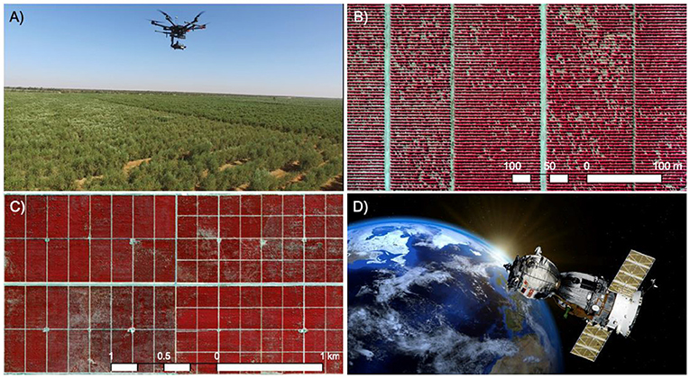
- Figure 2 - Cameras on drones and satellites can help us study the Earth at different scales.
- (A, B) Drones get up close to the Earth’s surface for detailed views. (C, D) Satellites fly high and give us a broader picture of large areas. In satellite and drone images, olive trees are shown using a special camera filter that lets scientists spot the healthy trees and the ones that are sick, by showing colors that we normally cannot see with our eyes.
Future generations have a crucial role to play in supporting scientists and contributing to the achievement of SDG 15. It is important for children to acquire knowledge about biodiversity, forests and land protection and to talk to their friends and the community about what they have learned. Young people can also participate in citizen science projects, in which they can contribute their own observations and findings to help monitor and understand ecosystems close to where they live. Participating in nature-protection activities, such as tree planting and habitat rehabilitation, allows young people to directly protect ecosystems in their neighborhoods and contribute to key aspects of SDG 15. Supporting protection organizations, “standing up” for nature, connecting with scientists and taking small actions can all work together to get the world closer to SDG 15. By nurturing a love for nature, learning about its value and actively engaging in protection efforts, people of all ages can contribute to creating a more sustainable, biodiverse world.
Glossary
Deforestation: ↑ Cutting down or removal of forests, often to clear the land for farming, logging, or development.
Biodiversity: ↑ The variety of living organisms, including plants, animals and microorganisms found in a particular environment.
Desertification: ↑ The process of fertile land turning into desert, often because of lack of rain and overuse of soil.
Remote Sensing: ↑ The method of collecting information about objects from a distance, typically using satellites or aircraft, without making physical contact.
Precision Agriculture: ↑ The use of technology to measure and manage changes in farm fields to reduce waste and optimize crop growth.
Conflict of Interest
The authors declare that the research was conducted in the absence of any commercial or financial relationships that could be construed as a potential conflict of interest.
Acknowledgments
We would like to thank Nicki Talbot at KAUST for her invaluable support during the review process, without which this collection would not have been possible. We would also like to extend our gratitude to the Office of Sustainability and UNDP-Saudi Arabia team for their dedication to raising awareness of the importance of the UN SDGs in our journey toward fight for a more sustainable world.
References
[1] ↑ Blanco-Sacristán, J., Johansen, K., Duarte, C. M., Daffonchio, D., Hoteit, I., and McCabe, M. F. 2022. Mangrove distribution and afforestation potential in the Red Sea. Sci. Total Environ. 843:157098. doi: 10.1016/j.scitotenv.2022.157098
[2] ↑ López Valencia, O. M., Johansen, K., Aragón Solorio, B. J. L., Li, T., Houborg, R., Malbeteau, Y., et al. 2020. Mapping groundwater abstractions from irrigated agriculture: big data, inverse modeling, and a satellite–model fusion approach. Hydrol. Earth Syst. Sci. 24, 5251–5277. doi: 10.5194/hess-24-5251-2020
[3] ↑ McCabe, M. F., Rodell, M., Alsdorf, D. E., Miralles, D. G., Uijlenhoet, R., Wagner, W., et al. 2017. The future of Earth observation in hydrology. Hydrol. Earth Syst. Sci. 21, 3879–3914. doi: 10.5194/hess-21-3879-2017