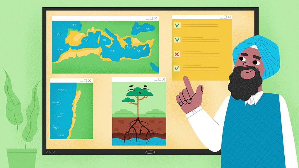
Abstract
Plants need water to survive, but what about plants living in places where it does not rain much? Some of these special plants send their roots down into the Earth to find water deep underground, which is called groundwater. But there is a problem: we do not know exactly where these plants are growing. Our mission? To create a new map to find and protect these incredible plants in regions with a Mediterranean climate. We used data from satellites and environment maps to uncover the best places for groundwater plants to grow in these areas. Then we developed rules to guide us, for example: “Plants that are green even when there is no rain” and “Plant roots that tap into the groundwater”. The rules helped us to create a map showing where these special plants might live. Guess what? Areas near the coast and along rivers are their favorite spots.
Why Should We Map Groundwater Plants?
Some special plants need groundwater to survive. These groundwater plants, called phreatophytes, can send their roots deep down in the ground to find hidden water, especially when it does not rain much [1]. For over 100 years, scientists have wanted to find out where groundwater plants are, to protect them and the important services they provide to nature and people, or to simply find new groundwater sources.
Some scientists study phreatophytes directly in the places where they grow. These scientists can create really detailed maps, but they often cover only small areas [1]. Nowadays, scientists often use maps or pictures from satellites to locate where groundwater plants might grow. The information they gather helps them create maps for entire countries or even whole continents [2].
But we wanted to go even bigger. In our study, we came up with a new way to find groundwater plants for an entire biome. We combined information from satellite pictures with environmental maps of vegetation, climate, soils, and terrain to create a map showing the places where these plants are most likely to grow. We looked at aspects like how much water is underground, how the plants behave when there is no rain, how well the rocks and the soils can hold water, and what the landscape looks like in general.
Mapping the Mediterranean
We mapped groundwater plants in the Mediterranean biome because it is an outstanding part of the Earth with many different plants, making it an important biodiversity hotspot. Due to dry, hot summers, plants there have developed various strategies to survive and some of them need groundwater.
But there is a big problem in the Mediterranean. In some parts, rainfall is decreasing due to climate change or people cutting down forests. At the same time, the use of groundwater for drinking and farming is increasing. These trends make it hard for phreatophytes to get enough water, putting them and the animals that depend on them at risk. There were not a lot of maps of the Mediterranean biome showing where phreatophytes grow. Such maps could help to locate these plants to better protect ecosystems and biodiversity by prioritizing areas for conservation, or inform local people about sustainable groundwater use.
Our main goal is to protect groundwater plants and their habitats to ensure a healthy environment and sustainable use of groundwater. By using our special map, people can decide where to study phreatophytes more closely, and we can protect them.
The Mediterranean Biome—A Special Place For Plants
The Mediterranean biome is formed by five different regions, as shown in Figure 1. Even though the regions are found in far-apart parts of the world, they have a similar climate and similar kinds of plants. In all five Mediterranean regions, the climate is usually warm, with annual temperatures between 14 and 18°C. Most of the rain falls during the winter months. But it does not rain a lot during the summer, so the ground can get very dry.
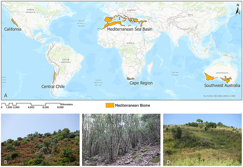
- Figure 1 - (A) The five Mediterranean regions that together form the Mediterranean biome.
- Typical vegetation in the Mediterranean biome includes: (B) scrubland, (C) evergreen holm oak forests, and (D) scrubland and pines.
The plant life of the five Mediterranean regions consists mainly of evergreen forests and scrubland (Figure 1). The vegetation is dominated by hardy, tough plants with strong leaves. Although the plants in the five regions are slightly different, they have similarities in the ways they look and grow. During the dry periods of the year, plants must be really smart and either save water or use groundwater to survive.
We Need a Lot of Data to Spot Groundwater Plants
Our main goal was to spot places where there is a lot of groundwater and where plants could easily reach it. To find these areas where groundwater plants could grow, we needed a lot of different kinds of data to describe the environment and the plants and their behavior. In total, we needed 17 datasets to spot groundwater plant areas in the Mediterranean biome.
We also used a mix of different maps that each told us something about the environment. As you can imagine, specialized plants often need special environmental conditions to grow, such as access to groundwater or soils that allow root growth and water movement. We also looked at satellite pictures to check how healthy plants were during dry periods.
What Can Environment Maps Tell Us?
There are a lot of special maps about climate, rivers and lakes, soils and rocks, vegetation or landforms (just like in an atlas) that can tell us how the environment looks in places all over the world. Luckily, many of these global maps are available from other scientists and can be used to figure out suitable conditions for groundwater plants to grow. Our first goal was to find these maps and gather them in a special computer system called a geographic information system (GIS). In the GIS, we looked at all the maps and decided which of them were the best to find groundwater plants [3]. In the end, we had nine maps that described different environments in the Mediterranean biome. But maps about plant health were not available yet. In the next step, we decided to create our own, using satellite data.
What Can Satellites Tell Us?
A lot of satellites surround our planet and take pictures of Earth’s surface, which are really helpful for creating all kinds of maps. We studied the pictures from a satellite called MODIS. MODIS takes a picture of the whole Earth every 16 days. These pictures can help us to see where cities, forests, or water bodies are located. But that is not all. The pictures can also tell us something about how well plants are doing, by looking at how green they are.
First, we used these satellite pictures to check for plants during the summer dry periods in the Mediterranean biome. During these dry spells, it is really hard for plants to stay healthy because they do not get enough water. We think that groundwater plants are healthier and greener than other plants during these periods because they can use groundwater. So, we highlighted those “green islands” all over the Mediterranean biome [4].
The MODIS satellite can also tell us how much plants and soils are sweating. Yes, plants and soils sweat, too. Especially when it is really hot, they release water vapor in the air through a process called evapotranspiration (ET). If the plants and the soil release more water into the air than they get from rain, we assume that they have a secret water source—probably groundwater [2].
Rules For Finding Groundwater Plants
Each of our maps told us something important about where groundwater plants like to grow and how they use water from the ground. To better understand where these groundwater plants areas are, we defined the following rules for the satellite images (rules 1 and 2) and for the environment maps (rules 3–8):
1) Plants are green, even when there is no rain.
2) Plants and soil release more water (by ET) than the amount of rain that falls.
3) Plant roots tap into the groundwater.
4) There is not much water stored in the soil.
5) The landscape is rather flat without high mountains.
6) Surface water collects in special landforms and can become groundwater.
7) Natural vegetation such as evergreen forests or wetland vegetation is present.
8) The rocks allow rainwater to get into the ground (but not too deep).
We applied the rules to our maps and used the GIS to lay all of the maps on top of each other, to decide where plants access groundwater. When most of the rules were true for an area, we thought that groundwater plants could grow there. But if plants were not very green in the dry period and the roots did not reach the groundwater, the plants were more likely to be non-groundwater plants (Figure 2).
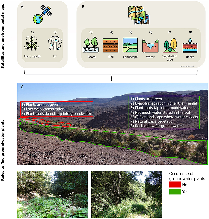
- Figure 2 - We combined (A) satellite data and (B) environmental maps using our eight rules to find groundwater plants.
- (C) Typical vegetation found in an oasis in Morocco. In the red area, our rules indicated non-groundwater plants, because plants are not green and do not reach the groundwater. In the green area, all of our eight rules applied, and we found groundwater plants. (D, E) Typical groundwater plants found in southern Italy.
In the end, we wanted to make sure that our map was as accurate as possible. So, we looked at locations where we knew for sure groundwater plants exist and compared them with our results. Some of these places were in Italy, where we went ourselves, and some were in California (USA), where other scientists went [5].
The New Groundwater Plants Map
In our final groundwater plants map, we found that lots of places in the Mediterranean biome provide good conditions for these special plants. Their favorite spots are near the coast and along the rivers. From all the natural places in the Mediterranean biome, about 31% of them are perfect homes for phreatophytes. Another 37% of places are pretty good for them, but not as perfect. And 32% are not very good homes for groundwater plants (Figure 3).
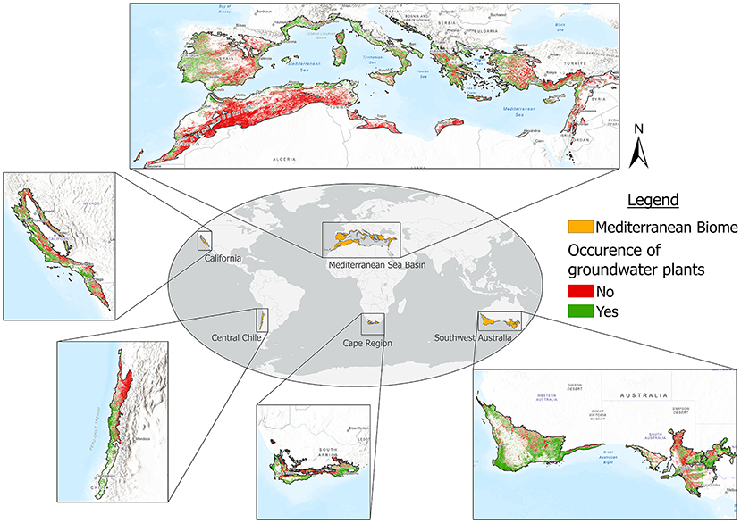
- Figure 3 - Our final map shows the occurrence of groundwater plant areas in the Mediterranean biome.
With the help of this map, we now better understand where groundwater plants are located in the Mediterranean biome. This is important for their protection, the protection of biodiversity, and sustainable groundwater management. For instance, regional authorities can look at our map and decide where groundwater should not be extracted to protect healthy groundwater plants there. On the other hand, our map can also help people to find new groundwater resources for nearby populations. By learning what makes phreatophytes happy and translating this into simple rules, we were able to use satellites and environmental maps to find their favorite spots in the Mediterranean. Now we have taken a first step toward protecting these special plants and the biodiversity they support.
Glossary
Groundwater: ↑ Water that is found beneath the Earth’s surface, filling the spaces between rocks and soil particles.
Phreatophytes: ↑ Special plants with deep roots that suck up groundwater to survive.
Biome: ↑ A large area where plants and animals have similar homes and ways of living.
Mediterranean Biome: ↑ Five regions on Earth with similar climate (mild temperatures, dry summers, and rainy winters). The vegetation is dominated by evergreen forests and scrubland.
Biodiversity: ↑ The rich variety of life on Earth, including variety in genes, species and ecosystems.
Landforms: ↑ Different shapes of the Earth’s surface, like mountains, hills, valleys, or plains.
Geographic Information System (GIS): ↑ A tool to create and study geographical data and maps on a computer.
Evapotranspiration (ET): ↑ The movement of water from the Earth’s surface to the atmosphere by evaporation (from the ground) and transpiration (from plants).
Conflict of Interest
The authors declare that the research was conducted in the absence of any commercial or financial relationships that could be construed as a potential conflict of interest.
Acknowledgments
The research was funded by the Federal State of Saxony-Anhalt via the MLU|BioDivFund.
Original Source Article
↑El-Hokayem, L., De Vita, P., Usman, M., Link, A., and Conrad, C. 2023. Mapping potentially groundwater-dependent vegetation in the Mediterranean biome using global geodata targeting site conditions and vegetation characteristics. Sci. Tot. Env. 898:166397. doi: 10.1016/j.scitotenv.2023.166397
References
[1] ↑ Meinzer, O. E. 1927. Plants as indicators of groundwater. USGS Water-Suppl. Pap. 1927:577. doi: 10.3133/wsp577
[2] ↑ Doody, T. M., Barron, O. V., Dowsley, K., Emelyanova, I., Fawcett, J., Overton, I. C., et al. 2017. Continental mapping of groundwater dependent ecosystems: a methodological framework to integrate diverse data and expert opinion. J. Hydrol. Reg. Stud. 10:61–81. doi: 10.1016/j.Ejrh.2017.01.003
[3] ↑ Duran-Llacer, I., Arumí, J. L., Arriagada, L., Aguayo, M., Rojas, O., González-Rodríguez, L., et al. 2022. A new method to map groundwater-dependent ecosystem zones in semi-arid environments: a case study in Chile. Sci. Tot. Environ. 816:151528. doi: 10.1016/j.scitotenv.2021.151528
[4] ↑ Akasheh, O. Z., Neale, C. M. U., and Jayanthi, H. 2008. Detailed mapping of riparian vegetation in the middle Rio Grande River using high-resolution multi-spectral airborne remote sensing. J. Arid Environ. 72:1734–44. doi: 10.1016/J.jaridenv.2008.03.014
[5] ↑ Klausmeyer, K., Howard, J., Keeler-Wolf, T., Davis-Fadtke, K., Hull, R., and Lyons, A. 2018. Mapping Indicators of Groundwater Dependent Ecosystems in California. San Francisco, CA: The Nature Conservancy.