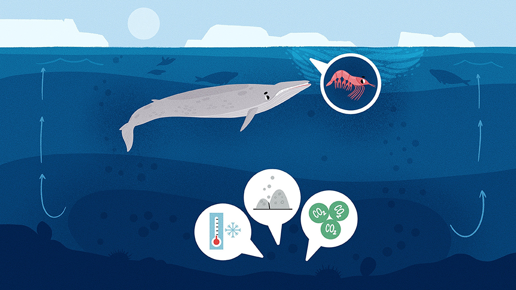
Abstract
Like a cake, the ocean is made up of several layers. The heaviest (highest density) layer of water on the bottom of the ocean is called Antarctic Bottom Water (AABW). AABW forms around the coast of Antarctica in areas where lots of sea ice is produced due to freezing temperatures and strong winds. When sea ice is formed, most of the salt from the sea water is left behind, so the water underneath the sea ice becomes very salty and cold, making it heavy and dense. This dense water sinks to the bottom of the ocean to become AABW. AABW acts like a pump, powering the circulation of ocean waters all over the world. With climate change, warming temperatures and melting ice sheets will influence the formation of AABW, which could affect global ocean circulation, climate, and the plants and animals living both in the oceans and on land.
We can think of the ocean like a cake with several layers. Imagine a cake with jelly on top (surface water), carrot cake in the middle (intermediate water) and mud cake on the bottom (bottom water). The layers of the ocean all have a different density (how heavy the water is), with the heaviest water on the bottom.
The density of water varies with temperature and salt. Warm water is less dense than cold water, and salty water is more dense than fresh water. For example, if you put soy sauce in water, it will sink to the bottom because it has a higher salt concentration and is therefore denser. In the ocean, when layers of dense water and less dense water are in contact with each other, the dense water sinks below the less dense water (Figure 1, bottom left). The dense water on the ocean bottom is either very cold and/or salty. But how are these layers created in the first place?
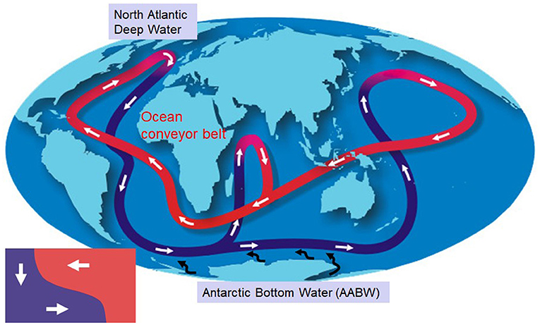
- Figure 1 - Water moves throughout the world’s oceans on a kind of “conveyor belt,” called the global ocean circulation.
- In this figure, purple shows water movement at the bottom of the ocean, and red shows water movement near the ocean surface. Colder, denser water sinks below warmer, lighter water (bottom left). Bottom water is formed at two areas, one around Antarctica (AABW) and the other near the Arctic (North Atlantic Deep Water) (figure modified from NOAA and NASA).
Antarctic Bottom Water Formation
Antarctic Bottom Water (AABW) is water that forms around Antarctica and sits at the ocean bottom, just above the seafloor. AABW is the densest water in the ocean. If you were to weigh the global ocean mass, AABW would be 30–40% of the total volume [1].
So, why is the densest bottom water found in Antarctica? Well, due to the cold air temperatures in Antarctica, the surface waters of the ocean are severely cooled and frozen, making a large amount of sea ice. In fresh water, ice forms at 0°C (like the ice in your freezer), but the ocean has salt in it, so it needs to reach -1.9°C to freeze. As the sea water freezes, 70–90% of the salt is left behind (rejected) from the ice and it sinks into the ocean beneath. This makes the water below the sea ice very salty and very dense.
Sea-Ice Factories Near the Antarctic Coast
Sea ice forms all around Antarctica, but we need lots of sea ice to make water salty enough to produce AABW. Normally, once sea ice grows thick and covers the ocean surface, it acts like a jacket, protecting the water underneath it from the cold air and preventing more sea ice from forming. This is similar to the way feathers keep a penguin warm. However, there are some areas around Antarctica where sea ice is formed constantly—in coastal polynyas.
A polynya is an area of ocean surrounded by sea ice (Figure 2). Strong winds that blow off Antarctica blow the sea ice away from the coast and create an area of open water. The newly exposed open water quickly freezes. But even as the new sea ice is made, ocean currents or strong winds blow it away from the coastline, exposing more surface water and maintaining the polynya. Because of the large amounts of sea ice polynyas create, they are often called sea-ice factories [2].
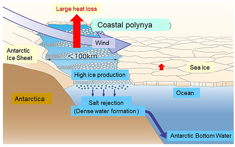
- Figure 2 - Coastal polynyas are called “sea-ice factories”, as they create lots of sea ice.
- Where newly formed sea ice is blown away by strong winds and currents, it exposes a body of water exposed to the cold open air, allowing more ice to grow. And the cycle continues! (modified from [2]).
With lots of sea ice forming, the water below the polynyas becomes very salty due to salt rejection, as well as very cold—making this water extremely heavy and dense. This dense water sinks down to the bottom of the ocean to become AABW!
Satellite Observation
There are many polynyas around Antarctica, but not all of them produce enough sea ice to generate AABW. The coastal areas of Antarctica are one of the world’s most difficult places to get to, especially in winter. It is very hard to get through the thick winter sea ice into the polynyas to take measurements of the ocean and sea-ice formation. Fortunately, we have a valuable tool that can help us measure sea-ice production without leaving our homes—satellite observation.
Satellites are launched into space, and they measure Earth’s surface remotely, using cameras and other sensors. A satellite can observe the Antarctic Ocean throughout the year, helping us to locate polynyas and how much heat is lost from them (Figure 2). Then, with the help of some computers and math, we can work out how much sea ice each polynya makes (more heat loss = more sea ice).
Figure 3 shows a map of annual sea-ice production over the entire Antarctic Ocean, created using satellite data. Areas of high sea-ice production are found around the coastline, but there are only four locations that produce enough to generate AABW. From the 1940s to the 1990s, scientists discovered that the Ross Sea, Weddell Sea, and Adélie Coast polynyas create AABW. This was discovered during research voyages to Antarctica that took direct measurements of the deep ocean. However, it was not until satellite technology developed in the 2000s that a fourth location—Cape Darnley—was also found to produce AABW [3, 4]. This was then confirmed by data collected from a research ship [3].
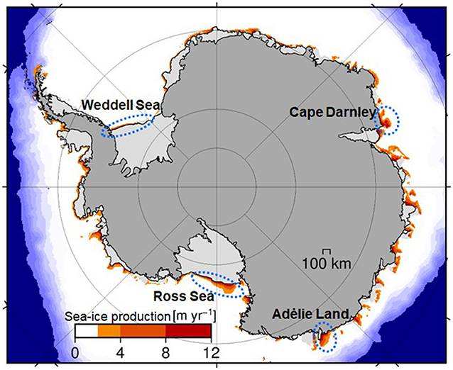
- Figure 3 - Map of annual sea ice production (in meters per year) and generation of Antarctic Bottom Water.
- The sea ice area is shown in white, and you can see that there is a high amount of new sea ice produced near the coasts, in coastal polynyas. The coastal polynyas highlighted in blue dotted ovals are those that make enough sea ice to produce AABW (modified from [5]).
Global Ocean Circulation
Look back at Figure 1, which shows the global ocean circulation, sometimes called the ocean conveyor belt. The water movement is driven by the differing densities of the ocean’s water masses. The sinking of AABW in Antarctica acts like a pump, driving deep, cold waters to the equator and warm water from the equator to the poles. This circulation distributes heat more evenly and maintains a mild and stable climate all over the world. Even though AABW is made in Antarctica, it can be found on the bottom of the ocean near the equator. As this cold AABW is transported to all the ocean bottom, it gradually rises in other areas of the world. On average, it takes water about 1,000–2,000 years to travel the entire ocean conveyor belt [6].
The Future
Over the past 100 years, the temperature of the atmosphere has been rising due to human activity, and this is called global warming. The ocean has taken up 90% of this heat, and the ocean’s bottom layer is also warming [7]. Scientists have revealed that warming of the bottom layer is caused by a reduction in AABW formation [7]. The melting of the Antarctic Ice Sheet, the largest single mass of ice on Earth, is also causing the oceans around Antarctica to freshen, reducing the amount of salt, and further reducing the density of the water. As global warming continues, it is predicted that the production of AABW will decrease even more, and this might weaken and slow down the global ocean conveyor belt. If the global ocean circulation were to slow or stop, Earth’s climate would change, and both ocean- and land-based ecosystems would be affected. We do not know exactly what would happen to the ocean circulation, climate, and ecosystems if AABW stopped forming, and scientists are using computer models of the ocean and climate to try to predict these future changes. Our understanding of this water mass is still growing and maybe you too could one day help us research and explore the unknowns of the deep sea.
Glossary
Density: ↑ How heavy something is compared to its size. In terms of water, colder temperatures and higher salt content make water denser.
Antarctic Bottom Water: ↑ (AABW): A layer of ocean water that is very cold and salty, so it is very heavy/dense and sinks to the sea floor.
Sea Ice: ↑ Ice frozen from sea water.
Polynya: ↑ An area of open water or thin ice surrounded by sea ice and land that produces lots of sea ice, which is blown away from land and keeps the polynya open.
Satellite Observation: ↑ Collecting images and other data about the Earth from satellites launched into space around the Earth.
Global Ocean Circulation: ↑ The movement of ocean water around the globe due to differences in the density of the ocean’s water masses.
Acknowledgments
KO acknowledges the support by Grants-in-Aids for Scientific Research of the Ministry of Education, Culture, Sports, Science, and Technology in Japan (20H05707). SB acknowledges the fund by the Australian Research Council Discovery Project Grant (DP220102525).
Conflict of Interest
The authors declare that the research was conducted in the absence of any commercial or financial relationships that could be construed as a potential conflict of interest.
References
[1] ↑ Johnson, G. C. 2008. Quantifying Antarctic bottom water and north Atlantic deep water volumes. J. Geophys. Res. 113:C05027. doi: 10.1029/2007JC004477
[2] ↑ Morales Maqueda, M. A., Willmott, A. J., and Biggs, N. R. T. 2004. Polynya dynamics: a review of observations and modeling. Rev. Geophys. 42:RG1004. doi: 10.1029/2002RG000116
[3] ↑ Ohshima, K. I., Fukamachi, Y., Williams, G. D., Nihashi, S., Roquet, F., Kitade, Y., et al. 2013. Antarctic Bottom Water production by intense sea-ice formation in the Cape Darnley polynya. Nat. Geosci. 6:235–40. doi: 10.1038/NGEO1738
[4] ↑ Ohshima, K. I., Fukamachi, Y., Ito, M. K. Nakata, M., Simizu, D., Ono, K., et al. 2022. Dominant frazil ice production in the Cape Darnley polynya leading to Antarctic Bottom Water formation. Sci. Adv. 8:eadc9174. doi: 10.1126/sciadv.adc9174
[5] ↑ Nihashi, S., and Ohshima, K. I. 2015. Circumpolar mapping of Antarctic coastal polynyas and landfast sea ice: relationship and variability. J. Climate. 28:3650–70. doi: 10.1175/JCLI-D-14-00369
[6] ↑ Matsumoto, K. 2007. Radiocarbon-based circulation age of the world oceans. J. Geophys. Res. 112:C09004. doi: 10.1029/2007JC004095
[7] ↑ Rhein, M., Rintoul, S. R., Aoki, S., Campos, E., Chambers, D., Feely, R. A., et al. 2013. “Observations: ocean,” Climate Change 2013: The Physical Science Basis. Contribution of Working Group I to the Fifth Assessment Report of the Intergovernmental Panel on Climate Change, Stocker, T. F., Qin, D., Plattner, G.-K., Tignor, M., Allen, S. K., Boschung, J., et al. (eds.). Cambridge: University Press, Cambridge, United Kingdom and New York, NY, USA, 1535.