Abstract
Antarctica is the coldest, driest, highest, and windiest continent, and it is home to 70 research stations from 29 countries. Antarctica is a remote and harsh place, without many weather stations or people. This means scientists must come up with creative ways to learn about the continent’s past climate. Scientists use sediment that builds up on the ocean floor to explore what Earth was like more than a million years ago; and they use satellites to learn about today’s climate. But how can we know what happened in the time between? This is where ice can help! When snow falls in Antarctica, it builds up in layers that get squeezed into ice. These layers hold traces of the past climate. The ice in Antarctica is the oldest anywhere in the world. Hundreds of thousands of years ago until now. These studies help us to better understand the past climate and to predict the future climate.
Past and Present Climates
These days, there is much talk about climate change, particularly the ways that human activities change the Earth’s natural climate and weather patterns. It is important to realize that climate and weather are not the same thing. When we talk about weather, we are describing what it is like outside at any given moment (whether it is sunny, rainy, or windy). On the other hand, climate refers to general patterns in weather over long periods of time. For example, the climate in Antarctica is typically cold and snowy; the Amazon rainforest is warm and usually rainy; and the Sahara desert is very hot and dry. Understanding natural climate patterns is important because it helps scientists predict what the weather will be like in the future. To understand how the climate is changing, we study what the climate was like in the past. This helps us to build better computer models that can predict how the climate might respond to human activities. So, how do we study what the climate was like years, centuries, or even millennia ago? This is where the field of science called paleoclimatology comes in—a field that involves the study of past climates.
What Tools Can Scientists Use To Learn About Past Climates?
Scientists use many tools to study the past climates. We typically refer to natural features that hold information about past climates as climate archives. For example, scientists look at the growth patterns of corals to figure out the past temperatures of the tropical ocean. We also look at tree rings, which form as trees grow, to understand what the seasons were like when and where those trees were growing. Ice from Antarctica and sediments from the oceans can tell us about the climates of the past, too. These climate archives all provide information about different environments, regions, and time periods (Figure 1). Taken together, all this information allows scientists to better understand the causes of climate changes that happened many years ago.
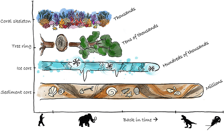
- Figure 1 - Climate archives vary in terms of how much of the past they can tell us about.
- For example, coral skeletons can tell us about Earth’s climate 1,000’s of years ago, but sediment cores can tell us what the climate was like millions of years ago. Image credit: Lea Desmay.
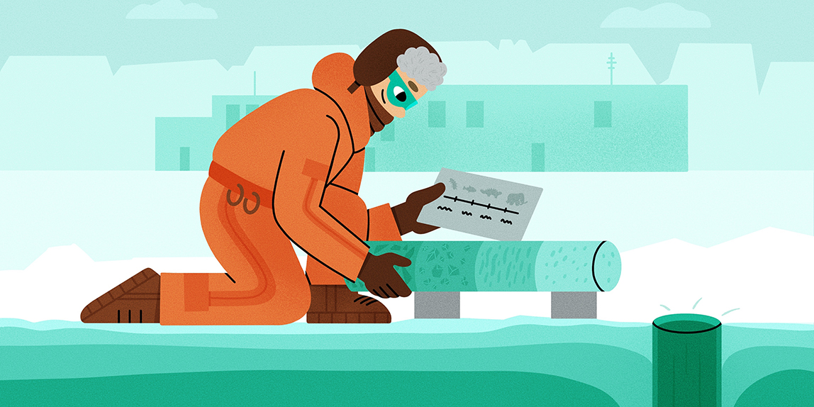
To get the ice and sediment that they want to study, scientists drill cores. Cores are long cylinders of sediment or ice, usually collected using a very large drill. The oldest continuous ice core is 800,000 years old, but some sediment cores can be many millions of years old. The deeper parts of the cores are the oldest, and the shallower parts are the youngest. While sediment cores tend to be older, ice cores can tell us about the past climate in much more detail. Scientists use various techniques to figure out what these cores contain and what that can tell us about the past climate. To learn how ice and sediment cores are collected, see this Frontiers for Young Minds article or this one.
Overview: Sediment and Ice Cores
The ocean contains more than just the plants and animals that we can see with our eyes—it also contains tiny, microscopic plants and animals known as plankton. When plankton and other creatures die, they sink to the ocean bottom and are preserved layer by layer in the sediment. Ice forms in a similar way, but instead of preserving plankton, they preserve gasses, particles, and other substances that are found in snow. Over time, the snow builds up in layers and gets squeezed into solid ice, trapping many substances, including carbon dioxide and volcanic ash in the ice. Both ice from Antarctica and the sediment from the ocean floor can be retrieved as long cylindrical samples known as cores. The deeper the section of the core, the older the ice/sediment is.
The Link Between The Oceans and Antarctic Ice
How do ocean waters in one part of the world influence ice cores far away in the Antarctic? The answer has to do with the elements that make up water (H2O). The oxygen (O) and hydrogen (H) that make up water have two forms: heavy and light. These forms are known as isotopes. At any point in time, the ocean contains a mixture of both heavy and light isotopes, and the ratio between the two isotopes changes depending on temperature. When the climate is cooler, there is less energy to evaporate heavy isotopes out of the ocean, so the clouds above the ocean contain more light isotopes than heavy ones. When the climate is warmer, there is more energy to evaporate heavy isotopes. Eventually, the isotope-containing clouds that formed over the oceans travel to Antarctica, dropping snow onto the continent. At the same time, the ocean deposits the isotopes not evaporated into the atmosphere into the sediments. Scientists can measure the ratio of light to heavy isotopes in snow, ice, and sediments to examine different past climate conditions over time.
The isotopes of hydrogen in ice cores tell us about Antarctic temperatures where the ice core was retrieved, like a thermometer; and tiny bubbles of air in ice cores help scientists to determine the amount of carbon dioxide that was present in the atmosphere in the past. Ice cores teach us about the relationship between carbon dioxide and temperature (Figure 2); the two follow the same pattern, rising and falling together over time, due to something called the greenhouse effect. The greenhouse effect is the way that gasses in the atmosphere absorb heat and keep the Earth warm, almost like a greenhouse [1].
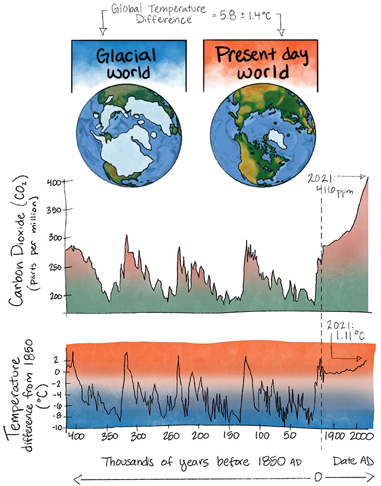
- Figure 2 - The Earth’s climate naturally varies between ice ages (glacial) and non-ice ages, with matching highs and lows in carbon dioxide and temperature.
- Humans started burning fossil fuels at a much higher rate around 1,850 (dotted line) this has resulted in the concentration of carbon dioxide in the atmosphere and the global average temperature increasing past the levels that we would expect if the fossil fuels had not been burned, i.e., in a world without humans [Data for figure: [2]].
Isotopes in the sediment can tell us about the total volume of ice that was present on the Earth; from the small amount of ice that exists today at the poles, to ice ages when much of the Northern Hemisphere was covered in thick ice. Over long cold periods, such as ice ages, ice sheets grow. This means more and more of the light isotopes from the ocean become “locked up” in the ice sheets. The opposite occurs when the climate is warmer—as the ice sheets melt, they return water with a higher number of light isotopes back to the ocean [3].
When we compare the gases and isotopes in ice cores to the isotopes in sediment cores, we see that ice ages occurred when there were low global temperatures and less carbon dioxide in the atmosphere. The patterns in the sediment isotopes match the patterns of the isotopes and carbon dioxide from ice cores and they all follow a remarkably similar pattern, rising and falling together over 100’s of 1,000’s of years. Together, sediment and ice cores help us paint a picture of the ancient history of Earth’s climate.
What Else Can Ice Cores Tell Us?
Ice cores not only tell us about the climate 100’s of 1,000’s of years ago, but they can also tell us about several 1,000’s of years ago in greater detail. It is very snowy in the coastal regions of Antarctica, so ice cores from those areas can tell us about seasonal changes in climate. Scientists can melt samples of the ice to measure the chemistry that represents changes in the ocean, sea ice, winds, volcanic activity, and even pollutants from far away. There are tiny amounts of salt in the ice, which comes from salty sea spray from the oceans. When the climate is stormy, the amount of sea spray that makes it into the ice increases. Therefore, scientists know that when the ice has more salt in it, the nearby climate was stormier and windier. In addition to sea salt, scientists can identify tiny amounts of ash from volcanos that erupted in the past. Big volcanic eruptions can significantly impact climate because lots of ash goes into the atmosphere, shading out the sun and cooling the climate. When scientists find traces of volcanic eruptions in the ice, it helps us understand their impact on climate. Traces of forest fires and bushfires can also be found in the ice, which can help us understand the chances that forest fires will increase in the future. In addition, Antarctica is far away from cities and industry. Measuring pollutants such as arsenic, lead, and other harmful substances allows scientists to study how much humans pollute the global atmosphere. Ice cores can also be used to monitor the success of any clean-up efforts.
When scientists look at information from ice and sediment cores, it is very helpful to compare what they see to what the climate looks like now. Using satellites that orbit the Earth, scientists can collect live data to monitor the world’s climate. These satellites can take very detailed pictures and other measurements. This is called remote sensing, and it can help us understand global climate patterns, including wind patterns, global sea level, and ocean temperatures. Remote sensing is especially helpful for getting information about very remote places where not many people live, like Antarctica. Combining information from climate archives, research station records, and remote-sensing data helps scientists develop the best possible computer models to predict future climate conditions.
Summary
Scientists have several tools to help study and understand the past climate of the Earth. These tools can be natural (ice cores, sediment cores, and coral and tree rings) or use modern technology (satellites and computer models). All these tools work together to give us an understanding of how the Earth’s climate has worked in the past and this knowledge is essential to predict how the climate will change in response to human driven changes.
Glossary
Weather: ↑ The state of the atmosphere at a specific place and time (i.e., windy, rainy, sunny, etc.).
Climate: ↑ The long-term weather conditions of an area (i.e., countries near the equator have a hotter climate than countries near the poles).
Paleoclimatology: ↑ The study (-ology) of past (paleo-) climate (-climat-).
Climate Archives: ↑ Features of the natural world used to learn about past climates. Examples include cores taken from ice sheets and marine sediments, tree rings, and coral skeletons.
Sediment: ↑ Soft, sand-like material at the bottom of the ocean, made up of particles that do not dissolve in sea water.
Cores: ↑ Cylinders of material (such as ice or sediment) usually collected using a large drill. These cores are used as climate archives.
Isotopes: ↑ Different forms of the same atom, with slightly different masses scientists can tell apart.
Remote Sensing: ↑ The use of satellites in Earth’s orbit to collect live data on weather systems and climate conditions on Earth and in the atmosphere.
Conflict of Interest
The authors declare that the research was conducted in the absence of any commercial or financial relationships that could be construed as a potential conflict of interest.
Acknowledgments
The authors would like to thank Lea Desmay for illustrating Figure 1. CC, MH, and JM would like to thank our past and present supervisors and research advisors for all of their support and encouragement. This includes Tessa Vance, Joel Pedro, Alexander Fraser, Andrew Klekociuk, Nerilie Abram, Sonya Fiddes, Delphine Lannuzel, Jodi Fox, Anders Svensson, and Helle Astrid Kjær.
References
[1] ↑ Jain, P. C. 1993. Greenhouse effect and climate change: scientific basis and overview. Renew. Energy 3:403–20. doi: 10.1016/0960-1481(93)90108-S
[2] ↑ Bertler, N. A. N., and Barrett P. J. 2010. “Vanishing ice sheets. p. 49–83,” in Changing Climates, Earth Systems, and Society, 1st Edn, ed J. Dodson (Springer). p. 360.
[3] ↑ Dansgaard, W. 1964. Stable isotopes in precipitation. Tellus 16:436–68. doi: 10.1111/j.2153-3490.1964.tb00181.x