Abstract
In the Arctic, the ground is frozen most of the year. Only the top layer of soil thaws each summer. This frozen ground, called permafrost, contains a lot of frozen water (ice). There are many small lakes in the Arctic, in low spots formed from melted ice. But melting ice does not just create lakes, it can destroy them too. Melting permafrost can create gullies that let the water drain out of a lake. Most lakes in the Arctic are far from where people live, so we watch them using pictures taken from satellites. Recently, we have seen the water drain out of many lakes, which can affect plants and animals. We measure the number and size of drained lakes caused by thawing permafrost to understand how the Arctic is changing.
What Is Permafrost?
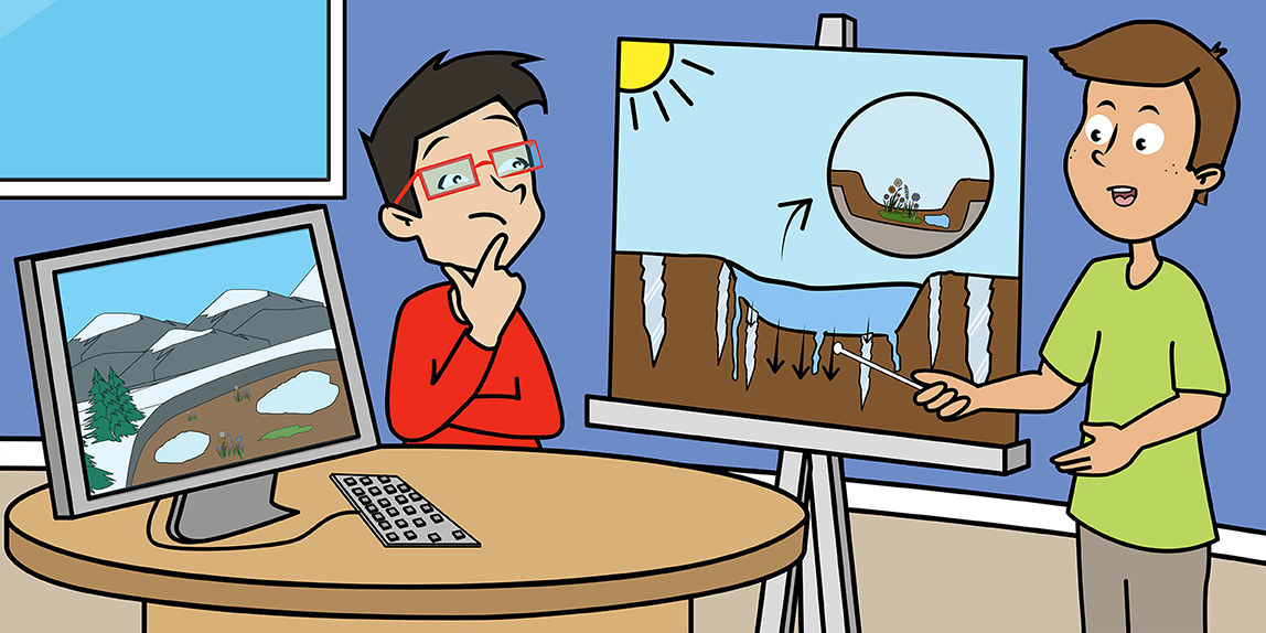
Permafrost is ground that stays frozen all year round. It forms in places with cold climates where the ground freezes so deeply in the winter that it stays frozen through the summer. Only the ground near the surface thaws in the summer. The part that thaws is called the active layer. That is where the action is: plant roots can grow, water can soak in, the soil can even slide downhill. Below the active layer is the permafrost, which stays solidly frozen all year long.
As summer progresses, the ground thaws from the surface downward. By the end of summer, the thaw slows down and eventually stops. When winter comes, the active layer freezes again.
Permafrost prevents water from snowmelt or rain from soaking deep into the ground. Where the ground is flat, the soil is often waterlogged and there are many lakes and ponds. The plants that grow in these environments are specially adapted to cold, wet soils. On hillslopes and in rocky areas, water can drain from the soils even when there is permafrost below. These dry places support different kinds of plants, and animals can dig burrows there, too.
Where Can We Find Permafrost?
Permafrost is found in the cold parts of the world. Large parts of Canada and Alaska have permafrost (Figure 1). Our map shows two permafrost zones that depend on how much of the land is underlain by permafrost. In the continuous permafrost zone permafrost is present nearly everywhere. In the discontinuous permafrost zone, permafrost is missing in warm places, such as sunny hillslopes. In the Arctic—the part of the world so far north that it is too cold for trees to live—most of the land has continuous permafrost.
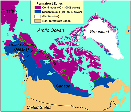
- Figure 1 - Permafrost map of North America.
- The colors represent zones that differ in how much land area is underlain by permafrost: continuous permafrost (90–100% permafrost cover) and discontinuous permafrost (10–90% permafrost cover). [Figure credit: simplified from Brown et al. [1]].
Ice in the Ground
Permafrost usually contains ice, known as ground ice. Where the ground is mostly sand and gravel, ground ice usually fills just the spaces between the grains. Where the ground is solid rock, ice is usually found only in the cracks in the rock. Where the ground is made of very small particles like silt and clay, ground ice is the cement that holds the ground together. Ground ice can also exist as masses of nearly pure ice. The most common kind of pure ice in permafrost is ice wedges, which create a distinctive pattern of polygons on the landscape (Figure 2). Ice wedges appear wedge-shaped when seen from the side, and when seen from above they form a network that follows the polygon outlines.
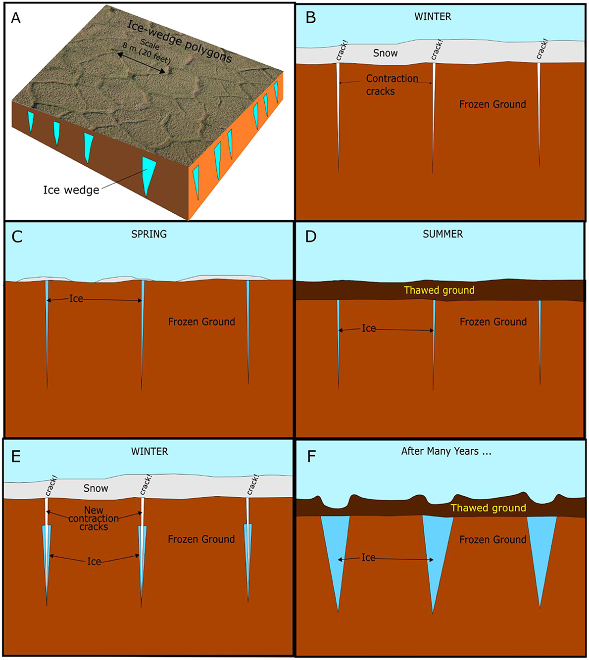
- Figure 2 - The formation of ice-wedge polygons.
- (A) An image from above showing ice- wedge polygons on the surface and the ice wedges underground. (B–F) The steps in the formation of ice wedges, as seen from the side. In winter the ground cracks, then in the spring the cracks fill with meltwater that freezes and lasts through the summer. In the following winter, the ground cracks in the same place and the wedge grows wider.
The way that ice wedges form was first discovered over 100 years ago [2]. Ice wedges form in permafrost by freezing and thawing over many years’ time. In the winter, the permafrost and the frozen active layer form a solid mass that contracts (shrinks) as it gets colder. If it contracts enough it will crack, usually in a pattern of polygons that reminds us of cracks in dried mud. Mud cracks also form by contraction as the mud dries. The difference is that the ice-wedge polygons are much larger than mud-crack polygons. Ice-wedge polygons are usually about 5–10 m (16–33 feet) across (Figure 2). When winter ends, the snow melts but the ground is still cold and the cracks are still open, so water flows into the cracks and freezes. Down in the permafrost, this narrow wedge of ice survives the summer thaw. The crack is a weak spot that is likely to crack again in the future, so the ice wedge will grow wider over time. In some places the wedges grow so wide that over half of the ground near the top of the permafrost is made of ice wedges. When permafrost contains a lot of ice it is called ice-rich permafrost.
Permafrost Thaw Lakes
Ice-wedge polygons are one of many unique permafrost landforms. Another permafrost landform closely tied to ice-wedge polygons is the thaw lake (Figure 3). Thaw lakes were first given this name and described over 70 years ago [3]. They form when ice-rich permafrost thaws in flat, wet environments. Thawing of permafrost causes the ground surface to sink down. In places with many large ice wedges, the ground can sink enough to form a basin for a lake, which is then called a thaw lake. Thawing of permafrost can begin with just a small pond. The water in the pond warms up by absorbing energy from the sun, causing ground ice below and next to the pond to thaw. Over time the pond becomes bigger and deeper, absorbing more energy from the sun and melting more ice. This process drives itself to speed up as time goes on. Thaw lakes are usually shallow, but they can grow to be more than 1 km (half a mile) across.
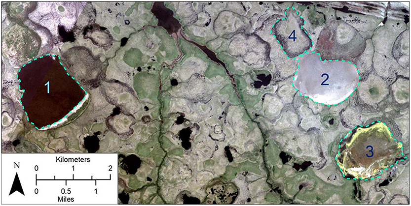
- Figure 3 - Thaw lakes in Bering Land Bridge National Preserve, Alaska, on a satellite image taken in July 2019.
- Lake (1) was still full of water, and appears black. The circle at (2) outlines the mud bottom of a former lake that drained just before the image was taken. The circle at (3) outlines a lake that drained in 2018, and vegetation has begun to grow on the lake bottom. The circle at (4) outlines a lake that drained long ago. The outlines of many other drained lakes are visible; all drained before our earliest aerial photographs from the 1950s.
The banks of thaw lakes do not hold back the water very well. Water from the lake can quickly cut a trench by melting the ground ice and washing away the soil. Water can flow out of the lake through a new trench, draining most of the water in just a few days. In places with thaw lakes, you can often see the outlines of lakes that drained both recently and long ago. These are most easily seen on pictures taken from airplanes or satellites (Figure 3). The study of the earth using images taken from above is called remote sensing. Remote sensing is very useful for the study of permafrost in remote places like the far north. It is especially interesting to study images taken at different times to see what changes have happened.
Many thaw lakes have drained in northern Alaskan parks in recent years. National Park Service scientists use satellite images taken every summer to measure the number and size of drained lakes caused by thawing permafrost, and to determine the year when they drained. We use computers to examine hundreds of satellite images. We found that 18 lakes drained in 2018 and 22 in 2019, while no more than 10 had ever drained in any single year since 2000. There are fewer lakes now than there were on the earliest historical images that we have (photographs from airplanes), which were taken 70 years ago [4–6]. In the northern plains of Bering Land Bridge National Preserve, the area of lakes is now almost 20% less than it was 20 years ago [6].
The weather in the northern Alaska parks has been warmer and snowier than normal in the past few years [7]. This has made it easier for new gullies to form and drain the lakes. The recent unusual weather is probably due to both natural year-to-year variations combined with long-term climate change. For centuries, lakes in the Arctic have been forming and draining [8]. However, climate change is probably causing them to drain more often now than they did in the past. When the climate warms, ice wedges that were solidly frozen in permafrost are more likely to melt and create new gullies and small ponds.
When lakes drain, they can no longer provide homes for water birds such as loons and ducks. On the other hand, animals can graze the lush new vegetation that grows on the bottoms of drained lakes. We have seen caribou, geese, and even grizzly bears grazing on drained lake bottoms. We will keep studying drained lakes to help us understand how the loss of lakes affects the plants and animals that live in the Arctic. Permafrost is very vulnerable to change as the climate warms. Draining lakes are just one example of how thawing of permafrost is changing the Arctic.
Funding
This work was funded by the National Park Service’s Inventory and Monitoring Program.
Glossary
Permafrost:: ↑ Ground that stays frozen year-round.
Active Layer:: ↑ Ground above permafrost that thaws during the summer.
Continuous Permafrost Zone:: ↑ Regions of the Earth where permafrost covers most (more than 90%) of the land area.
Discontinuous Permafrost Zone:: ↑ Regions of the Earth where permafrost is present but covers less than 90% of the whole land area.
Ice Wedge:: ↑ Ice in the ground that forms by repeated freezing and thawing. A contraction crack in permafrost fills with meltwater that freezes to form a wedge.
Ice-Rich Permafrost:: ↑ Permafrost that contains so much ice that it sinks or flows when it thaws.
Thaw Lake:: ↑ A lake that formed where the land sank due to melting of ice in the ground.
Remote Sensing:: ↑ The study of land or objects from a distance using cameras or other instruments. An example is the study of the Earth using images taken from satellites.
Conflict of Interest
The author declares that the research was conducted in the absence of any commercial or financial relationships that could be construed as a potential conflict of interest.
References
[1] ↑ Brown, J., Ferrians, O., Heginbottom, J. A., and Melnikov, E. 2002. Circum-Arctic Map of Permafrost and Ground-Ice Conditions, Version 2. Available online at: https://nsidc.org/data/ggd318 (accessed April 6, 2021).
[2] ↑ Leffingwell, E. K. 1915. Ground-ice wedges: the dominant form of ground-ice on the north coast of Alaska. J. Geol. 23:635–54.
[3] ↑ Hopkins, D. M. 1949. Thaw lakes and thaw sinks in the Imuruk Lake area, Seward Peninsula, Alaska. J. Geol. 57:119–31.
[4] ↑ Jones, B. M., Grosse, G., Arp, C. D., Jones, M. C., Walter Anthony, K. M., and Romanovsky, V. E. 2011. Modern thermokarst lake dynamics in the continuous permafrost zone, northern Seward Peninsula, Alaska. J. Geophys. Res. Biogeosci. 116:G00M03. doi: 10.1029/2011JG001666
[5] Swanson, D. K. 2019. Thermokarst and precipitation drive changes in the area of lakes and ponds in the National Parks of northwestern Alaska, 1984–2018. Arct. Antarct. Alp. Res. 51:265–79. doi: 10.1080/15230430.2019.1629222
[6] ↑ Swanson, D. K. 2020. Monitoring of Water Surface Area in Alaska’s Arctic National Parks: Update With 2019 Data. Natural Resource Data Series NPS/ARCN/NRDS-2020/1263. Fort Collins, CO: National Park Service. Available online at: https://irma.nps.gov/DataStore/Reference/Profile/2272062 (accessed May 28, 2020).
[7] ↑ Swanson, D. K., Sousanes, P. J., and Hill, K. 2021. Increased mean annual temperatures in 2014–2019 indicate permafrost thaw in Alaskan national parks. Arct. Antarct. Alp. Res. 53:1–19. doi: 10.1080/15230430.2020.1859435
[8] ↑ Jones M. C., Grosse G., Jones B. M., and Walter Anthony, K. 2012. Peat accumulation in drained thermokarst lake basins in continuous, ice-rich permafrost, northern Seward Peninsula, Alaska. J. Geophys. Res. Biogeosci. 117:16. doi: 10.1029/2011JG001766