Abstract
Across the Sacramento-San Joaquin Delta, spongy soil is sinking at a rapid rate! This issue, known as subsidence, happens in places with peat soils that have been drained. Peat soils are created over thousands of years by decaying wetland plants. Following European colonization of California, the Delta’s wetlands and their peat soils were drained, and levees were built to keep the land dry. Farms now thrive on this fertile landscape. However, as drained soils are exposed to oxygen, tiny microbes rapidly consume the peat soil, which makes the land sink. Now, many Delta islands look like giant salad bowls up to 9 m deep, with fragile levees holding the rivers back. This puts communities, farms, ecosystems, and water supplies at risk from floods. The microbes in the soil release carbon dioxide into the atmosphere, which contributes to climate change. Scientists and land managers are creating new wetlands to combat subsidence in the Delta.
Mysterious Sinking Islands
Imagine the earth beneath your feet disappearing. This may sound like something out of a horror movie, but it is happening across the world where wetlands have been drained. In the Sacramento-San Joaquin Delta (referred to as “the Delta”), hundreds of thousands of acres of farmland were created on former wetlands and the peat soils they created. Peat soils are soils formed under water by layers of decaying wetland plants. These types of soil are made of mostly organic (recently living) matter and they have lots of carbon and nutrients, making them great for farming.
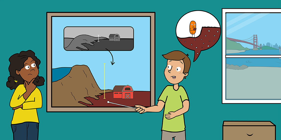
However, farming on peat soil holds a hidden risk: it can cause subsidence. Subsidence is the disappearance of soil that results in the lowering of the ground level. In some parts of the Delta, subsidence has lowered the soil surface up to 9 m in the last 170 years [1] (Figure 1)! This means that if a three-story house was placed in the most deeply subsided parts of the Delta, the top of its roof would be right at the level of the water running through the nearby rivers. How could this have happened?
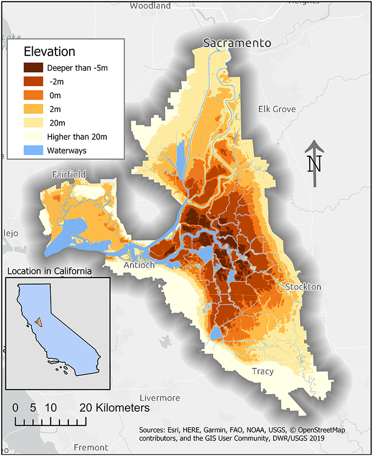
- Figure 1 - This map of elevations in the Sacramento-San Joaquin Delta shows the areas where subsidence has occurred.
- An elevation of 0 m indicates sea level, while negative elevations are below sea level. Notice that large areas in the central Delta have subsided to depths below sea level.
In the 1800’s, European colonizers came to California and stole land from the area’s indigenous people. The colonizers began to change that land considerably. The farms and towns that make up today’s Delta were mostly wetlands that were covered with water much of the time. To farm these wet areas, people constructed levees (also known as dikes) to make islands and drained the wetlands. The levees kept the water out and allowed a thriving agricultural industry to develop in the area (Figure 2). Unbeknownst to these early Delta farmers, draining the Delta’s wetlands had major consequences. Draining the land lets oxygen into the peat soil, which “wakes up” certain microbes, creatures so small you can not see them without a microscope. The microbes go to work eating the organic material and burping out carbon dioxide (Figure 3). The soil loses its structure, shrinks like a dry sponge, and is easily crushed. At first, the changes were gradual and hard to notice, but over the last century a crisis has developed. Some parts of the Delta are sinking up to 1.8 cm per year [2]! This will continue unless steps are taken now to combat subsidence.
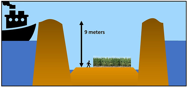
- Figure 2 - Subsidence in the Sacramento-San Joaquin Delta.
- Levees surround land and constantly hold water back. When water is drained from wetlands and the ground disappears due to subsidence, the levees are at greater risk of breaking, which could flood many farms and homes.
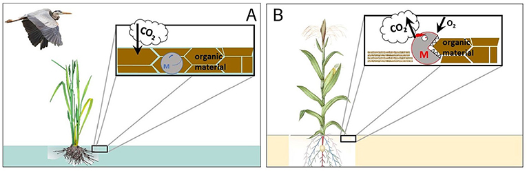
- Figure 3 - (A) In wetlands with plants like cattails or rice, the organic material (peat) is not broken down and can even build up.
- Maintaining water over the peat is critical because the microbes (M) that cause subsidence are not active under water. Flooded lands take up carbon from carbon dioxide (CO2), raise the ground level, and provide habitats for wildlife such as the blue heron. (B) When wetlands are drained for crops like corn, oxygen (O2) can enter the soil. This wakes up microbes (M) that devour organic material and burp out carbon dioxide (CO2), a greenhouse gas.
Why Is Subsidence A Problem?
So why is subsidence a problem in the Delta? First, hundreds of thousands of acres of farmland and many small towns in the Delta are now protected by levees. These levees are constantly holding rivers back from spilling into farms and communities, 24 h a day, 365 days per year. The more the land sinks, the greater the pressure on the levees, and the greater the risk of levees breaking and flooding people’s homes and farms. Levees in the Delta have broken 87 times in the last 70 years [1]. A levee broke in 2004, flooding hundreds of acres of farmland, and costing over $90 million USD to fix [2]! Approximately 40% of the state of California drains stormwater through the Delta so, during storms, water levels can get so high that water flows over the tops of levees. The deeper the subsidence, the harder it is to repair broken levees or to pump water out if it floods. This puts hundreds of thousands of acres of farmland, wildlife habitat, and communities at risk of catastrophic flooding. Unfortunately, this risk will only increase as climate change raises water levels and subsidence continues.
Another reason subsidence is a problem is that levees do not only protect the land they surround, they also protect one of California’s most valuable resources: fresh water. The State Water Project and the Central Valley Project provide water for 2 out of 3 Californians in Los Angeles and other cities, and for millions of acres of farmland in California’s Central Valley. This important water flows from large reservoirs in the mountains and must pass through Delta waterways. At times, the Delta waterways can be a little salty because they are connected to the Pacific Ocean. Saltiness increases during high tides and when freshwater flow is limited. The levees in the Delta play a critical role in keeping the water fresh: if they break, salt water will push far into the Delta. This could endanger the largest source of California’s drinking water and much of the produce we enjoy.
Subsidence is also a problem because subsided lands cannot be restored to tidal wetlands, which are critical for the ecological health of the Delta. Tidal wetlands are ecosystems where plants grow in areas covered by water all or part of the time because they are physically connected to larger bodies of water. They also provide critical habitats for fish, birds, and other organisms, many of which are endangered and may go extinct without restoration. Over the last 170 years, over 95% of the Delta’s tidal wetlands have been destroyed. Subsidence greatly limits the ability to restore most of the tidal wetlands in the region, because these wetlands can only exist if the elevation is near sea level. Many subsided areas have sunk below sea level, which means that attempts to create tidal wetlands on subsided islands would create a lake-like habitat instead.
The negative impacts of subsidence are not only seen in the Delta region—subsidence can also impact the entire Earth, by contributing to climate change. As peat is exposed to the air, microbes break down the peat soil by eating the organic material (Figure 3B). Like cars that run on gas, these microbes run on peat and emit carbon dioxide. This process produces huge amounts of carbon dioxide, a greenhouse gas that contributes to climate change, that escapes into the atmosphere [3]. Subsided Delta islands contribute about 2 million cubic tons of carbon to the atmosphere each year [2], or about the same amount of pollution produced by 300,000 cars.
Solutions To Subsidence in The Delta
You may find yourself asking, “Why do not we just fill up subsided areas with soil to bring them back up to safer elevations?” Unfortunately, this would require an enormous amount of soil. In fact, if you were to fill Disneyland with soil 1 foot deep, you would need to truck in about 75,000 Disneylands to bring the subsided Delta islands up to sea level [4]. There is simply no source of soil that could make this work!
So how are scientists and land managers working to prevent or reverse subsidence? The solutions all involve returning conditions on Delta islands closer to what they used to look like. The first step is covering the soil with water. Even a shallow pond stops the subsidence-inducing, carbon-producing microbes from eating away at the ancient peat soil. Some farmers in the Delta have started growing rice, which needs flooded soil for much of the year. Rice farming stops subsidence in its tracks while still producing food.
There is an even more powerful tool that not only stops subsidence but reverses it! What kind of amazing technology could be used to achieve this? The answer is non-tidal wetlands managed by humans. Although it is not possible to restore tidal wetlands on subsided islands, humans can pump water in and create vast areas of non-tidal wetlands below sea level, protected by levees. Once under water, these wetlands can create and build up peat soil, which increases their elevation [2].
It will take many years for wetlands in deeply subsided islands to reach sea level. In the meantime, human-made, non-tidal wetlands can take pressure off levees and reduce the risk of flooding with every centimeter of newly built soil they produce. Wetlands also provide habitats for wildlife like river otters, great blue herons, white pelicans, and numerous other species. Land managers have restored over 2,000 acres of non-tidal wetlands on subsided islands, and many thousands more acres of restoration are planned.
Another benefit of returning water to peat soils by creating wetlands or rice fields is that it stops the carbon dioxide emissions that contribute to climate change (Figure 3A). Land managers and scientists are working together to monitor greenhouse gas emissions from newly created non-tidal wetlands. Wetlands do not just stop the emissions; they actually soak up carbon dioxide in a process known as carbon sequestration. Even outside of California, companies and governments looking to reduce their contributions to climate change will often pay the state for carbon sequestration. So, these newly created, non-tidal wetlands not only produce new habitats, reverse subsidence, and sequester carbon, but they can also earn money.
We Must Think Ahead!
The issue of subsidence in the Delta illustrates how people’s past actions can influence current environmental conditions. If the early land conversion in the Delta had not happened, we would not need to deal with the difficulties caused by subsidence. Like many big environmental challenges such as climate change or global deforestation, the problems started before anyone alive today was even born. These environmental concerns can seem overwhelming. While we cannot change history, we can think ahead. We can use science to prevent future environmental damage and help identify solutions to current problems to benefit humans and the environment for generations to come.
Glossary
Wetland: ↑ Also known as a marsh, land that is typically covered in water or plants that can handle flooded conditions.
Peat: ↑ A natural brown substance in soils formed by the breakdown of dead plants and other organic material. It takes a long time to form and must be created under water.
Subsidence: ↑ The lowering of the ground level, which can be caused by microbial breakdown of organic matter, wind erosion, compaction, or groundwater pumping.
Levees: ↑ Also known as a dike, a structure that prevents water from entering the land. Levees are usually long mounds of dirt that hold water back.
Microbes: ↑ Tiny living creatures that cannot be seen by the human eye, which are responsible for many chemical and physical changes to the environment.
Tidal Wetland: ↑ A type of wetland or marsh that is flooded and drained by tidal movement from the estuary, sea, or ocean.
Carbon Sequestration: ↑ Removing carbon dioxide from the atmosphere and storing it for a long time.
Conflict of Interest
The authors declare that the research was conducted in the absence of any commercial or financial relationships that could be construed as a potential conflict of interest.
Acknowledgments
Thank you to the Delta Stewardship Council and Delta Science Program for supporting us in our work.
References
[1] ↑ Deverel, S. J., Dore, S., and Schmutte, C. 2020. Solutions for subsidence in the California Delta, USA, an extreme example of organic-soil drainage gone awry. Proc. IAHS. 382:837–42. doi: 10.5194/piahs-382-837-2020
[2] ↑ Deverel, S. J., Ingrum, T., and Leighton, D. 2016. Present-day oxidative subsidence of organic soils and mitigation in the Sacramento-San Joaquin Delta, California, USA. Hydrogeol. J. 24:569–86. doi: 10.1007/s10040-016-1391-1.
[3] ↑ Knox, S. H., Sturtevant, C., Matthes, J. H., Koteen, L., Verfaillie, J., and Baldocchi, D. 2015. Agricultural peatland restoration: effects of land-use change on greenhouse gas (CO2 and CH4) fluxes in the Sacramento-San Joaquin Delta. Glob. Change Biol. 21:750–65. doi: 10.1111/gcb.12745.
[4] ↑ California Department of Water Resources. Delta LiDAR 2017. California Department of Water Resources (2018). Available online at: http://gisarchive.cnra.ca.gov/iso/ImageryBaseMapsLandCover/LIDAR/DeltaLIDAR2017/ (accessed September21, 2020).