
Abstract
Scientists learn about Earth’s future climate by looking at geological records from the past. About 3 million years ago, most of the east coast of the United States was under water. Sediments collected on the ocean floor show that the ocean environment was warmer and supported more species back then. Some of these sediments are now exposed above water as cliffs along the James River near colonial Jamestown in southeastern Virginia. Tiny fossils and other evidence in these sediments, which we call the Yorktown Formation, show us how the environment and ecosystems were affected by global warming in the past, and they hold many clues as to what Earth may look like in the future.
Geology At Jamestown, Virginia
For thousands of years before John Smith founded the colony of Jamestown (Virginia, USA), Indigenous people hunted, fished, and lived along what is now the James River (Figure 1). They observed the seashells in the cliffs but may not have realized the story those shells could tell. That story began 3 million years earlier, long before people inhabited North America, and even long before the ice ages. Three million years ago, the Virginia coastline was more than 80 km (about 50 miles) further inland compared to where it is today, and the area around southeastern Virginia was under 18 m (60 feet) of water and full of ocean life. The ocean sediments deposited at that time form what is now known as the Yorktown Formation. The Yorktown Formation has four main layers, called the Sunken Meadow, Rushmere, Morgarts Beach, and Moore House.
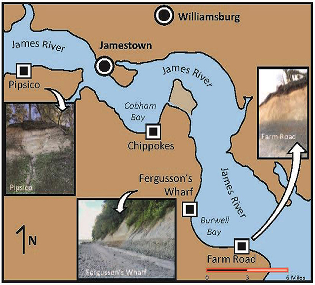
- Figure 1 - Map of the James River in southeastern Virginia, showing the locations of the historic cities of Jamestown and Williamsburg.
- It also shows the locations of our study sites at the Pipsico Scout Reservation, Fergusson’s Wharf and Farm Road. In these locations, the Yorktown Formation is exposed in cliffs. The photos show what the Yorktown Formation cliffs look like now.
The Yorktown Formation has two parts, a lower part (Zone 1), and an upper part (Zone 2) [1]. Zone 1 and Zone 2 are separated by what geologists call an unconformity (the thick wavy horizontal line in Figure 2A). This happens when sea level falls and the sediments that were deposited under water are exposed to the air, eroded, and removed from the geologic record. When sea level rises again, the sediments that were left behind are covered by the sea once again, and new sediments are deposited on top of them. The unconformity between Zones 1 and 2 in the Yorktown Formation represents a major drop in sea level that resulted in a big age difference between sediments at the top of Zone 1 and at the bottom of Zone 2. The lower part of Zone 2 was deposited as sea level rose, and these sediments are much younger than those at the top of Zone 1. So, the unconformity is an age gap where sediments are missing.
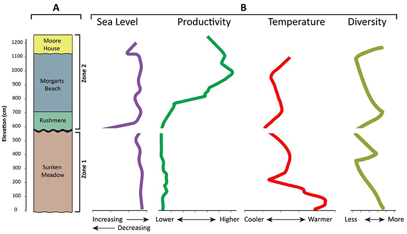
- Figure 2 - (A) The Yorktown Formation has four layers, which are divided into two zones: Zone 1 (the Sunken Meadow layer) and Zone 2 (the Rushmere, Morgarts Beach, and Moore House layers).
- The black horizontal wavy line between Zone 1 and Zone 2 indicates an unconformity, where sediment is missing. (B) The graphs show changes in sea level, productivity, ocean temperature, and species diversity through time. You can see that the lower part of Zone 2 shows rapid increases in sea level and temperature, like what is happening today.
This particular drop in sea level happened in all the world’s oceans during the Late Pliocene, about 3.3 million years ago [2]. At that time, a brief period of cooler temperatures caused glaciers on land to grow, trapping water in the form of ice. This reduced the volume of water left in the oceans and caused sea level to fall by about 60 m (almost 200 feet) [3]. When the climate warmed again, sea level rose rapidly, mostly due to the ice melting—like what is happening today. Carbon dioxide (CO2) in the atmosphere was also at similar levels then as it is today. CO2 is a greenhouse gas that traps heat in Earth’s atmosphere. So, the climate of the Late Pliocene was like today’s climate in several ways. Scientists have studied Late Pliocene geology all over the world, looking for clues about what to expect as Earth’s climate changes. It turns out that southeastern Virginia is one of the best places to look.
Fossils, Large, and Small
Paleontologists examine the fossils of the Yorktown Formation to understand what happens to marine environments as the climate warms. Some seashells found in the Yorktown Formation are as big as dinner plates! One species, named Chesapecten jeffersonius, is the state fossil of Virginia (Figure 3A). These shells and some from other mollusks (species like squids, snails, or clams) provide information about the temperature of the water where they lived. They can even tell us about seasonality from when they were alive [4]. Seasonality determines things like how ecosystems function, what crops can grow in a particular region, and even affects tourism.
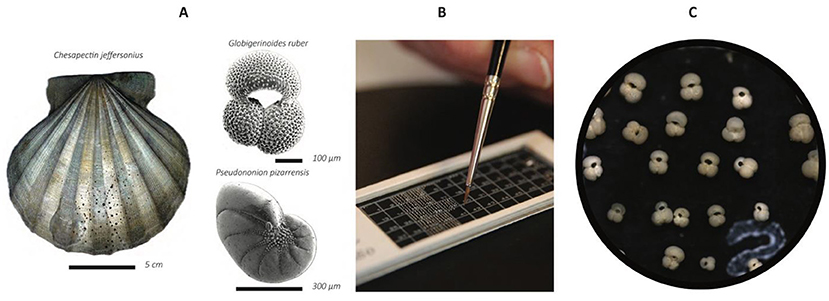
- Figure 3 - (A) Fossils from the Yorktown Formation: a mollusk, a floating foraminifer (top), and a bottom-dwelling foraminifer (bottom).
- The mollusk is the State Fossil of Virginia and can be as big as a dinner plate, but the foraminifera are each about the size of a grain of sand. (B) Using a fine-tipped paintbrush, foraminifera are transferred to a 3" × 1 cardboard container called a micropaleontological slide and are lined up by species in rows and columns. (C) A close up of box #2 from the micropaleontological slide, showing what we see when we look through a microscope.
Some of the most useful fossils in the Yorktown Formation are microscopic foraminifera. Foraminifera are single-celled organisms about the size of a grain of sand that form beautiful shells (Figures 3A, C). Some passively float at the water surface, and others live on or in the sediment at the ocean bottom. The types and numbers of species of foraminifera can tell us a lot about the environment and ecosystems in which they were living. By studying foraminifera from the Yorktown Formation, we can discover how the environment was affected by climate change in the past.
Even smaller than foraminifera are biomarkers or “chemical fossils”. These are carbon-containing molecules produced long ago by certain phytoplankton or algae. After those organisms died (they were probably eaten), the molecules settled through the water and became trapped in the sediment. By studying the number and arrangement of carbon bonds in the molecules, scientists can determine the temperature of the water when the algae were alive. By analyzing the biomarkers, we can learn about the temperature of the surface water and get an idea of the level of surface productivity, which means how well the ocean surface supported life and how much life was present. A high productivity level is a sign of a very active ecosystem.
We specialize in the study of foraminifera fossils. To get our samples, we used a shovel to scoop out sediment samples—about the size of a grapefruit—from the outcrops. We then dried the sediment in an oven. Once the samples were dry, we soaked them in water and washed them through a sieve to get rid of any clay and fine silt, and to obtain bigger particles. We used a microscope with up to 100X magnification and a fine-tipped paint brush to move individual fossils to a special slide (Figure 3B).
What Do the Fossils Say?
We wanted to learn about Late Pliocene ocean temperatures along the US mid-Atlantic coast, to get a better idea of what we might expect in the future. We looked at biomarkers and foraminifera in our samples. The biomarker method of estimating temperature is really accurate, meaning we can calculate temperatures to within about 0.1°C (~2°F) of the actual temperature. The total amount of these molecules in a sample can also tell us how productive the waters were. We calculated how many individual foraminifers there were, how many different species there were, and how many individuals were in each species.
The biomarkers showed that the ocean surface temperatures in different parts of the Yorktown Formation varied between 24.5 and 27.4°C (76.1 and 81.3°F). The temperature increased rapidly after the unconformity during deposition at the base of Zone 2, then decreased, and finally rose again (Figure 2B). Temperature is an important factor in determining productivity. Productivity remained relatively consistent throughout Zone 1 but increased in Zone 2, peaking in the middle of Zone 2. This very high productivity is much higher than we see off the coast of Virginia today and is more like the most productive parts of the Atlantic Ocean.
The type of foraminifera also changed during Zone 2. Immediately following the unconformity, the number of both bottom-dwelling and floating foraminifers and the species diversity increased and then peaked in the lower part of Zone 2, where the temperature also peaked (Figure 2B) [5]. Overall, we found 25 species of floating foraminifers and 50 species of bottom-dwelling foraminifers in the Yorktown Formation.
In general, following the big drop in sea level about 3.3 million years ago, sea level rose rapidly, temperatures increased, productivity of surface waters increased, and diversity of foraminifers increased. Our results show that the ocean off the mid-Atlantic coast was 3–5°C (5–9°F) warmer during the Late Pliocene than it is today, supporting a diverse warm-water ecosystem.
Back To The Future?
About three million years ago in what is now southeastern Virginia, sea level was higher than today. From the species of foraminifers, we can tell that summer temperatures were not too much different than they are now, but winter temperatures were much warmer. That means there was less change between seasons, similar to present day coastal conditions closer to the equator. Coastal seasonality can change when the positions of ocean currents change, bringing warmer water along the coast. The changing position of a warm current called the Gulf Stream could have prevented cool coastal currents from the north from reaching Virginia, changing the temperature dramatically. Our evidence that productivity of the water changed over time supports the idea that ocean currents were also changing.
Even though the high amount of CO2 in the atmosphere was about the same in the Late Pliocene as it is today, temperatures were warmer and sea level was higher. That is because our current climate is still adjusting to rising CO2 levels. As our temperatures warm and sea level rises, we may return to conditions something like we had 3 million years ago. We might expect increased productivity that at first supports higher diversity of foraminifers but ultimately leads to decreases in diversity like what we observed in Zone 2 of the Yorktown Formation. Since the economy of coastal regions often depend upon fishing, monitoring changes in diversity is critical for planning for the future.
To better understand the Late Pliocene environment in southeastern Virginia, we need more information. We need better ways to determine the age of the various parts of the Yorktown Formation and to continue to study the tiny fossils and molecules found in the sediments. With more data, we can learn even more about what happened during this time, how various types of sea life were impacted, how plants and animals adapted to big changes in the climate, and how quickly or slowly these changes and adaptations occurred.
Summary
Climate change poses a significant threat to our planet, and scientists are working to understand and predict its potential effects. By studying past climates like the Late Pliocene, researchers gain valuable insights into how the climate system works. Yorktown Formation fossils provide important information about the impact of high CO2 levels on ocean environments, temperature patterns, currents, and sea-level changes. Studying the Yorktown Formation helps scientists to expand their knowledge of Late Pliocene climate and its impact on this region. This research is crucial in helping us better address the challenges posed by future climate change.
Glossary
Unconformity: ↑ A boundary between rock or sediment layers formed by erosion or a pause in sediment accumulation and representing missing time in the geological record.
Geological Record: ↑ Layers of rock and sediment that record the history of the Earth.
Paleontologists: ↑ Scientists who study how the Earth works and who focus on fossils.
Seasonality: ↑ Changes in the weather based on changing seasons.
Foraminifera: ↑ Single-celled marine organisms that secrete complex calcium carbonate shells.
Biomarker: ↑ An organic compound or “chemical fossil” produced by an organism that lived in the past.
Productivity: ↑ A measure of the amount of living things present in the ocean.
Diversity: ↑ The variety and abundance of species within a community.
Acknowledgments
The original work has been supported by the U.S. Geological Survey Climate Research and Development Program and National Science Foundation grant NSF OC#-1459280.
Conflict of Interest
The authors declare that the research was conducted in the absence of any commercial or financial relationships that could be construed as a potential conflict of interest.
Original Source Article
↑Dowsett, H. J., Robinson, M. M., Foley, K. M., and Herbert, T. D. 2021. The Yorktown Formation: improved stratigraphy, chronology, and paleoclimate interpretations from the U.S. mid-atlantic coastal plain. Geosciences 11:486. doi: 10.3390/geosciences11120486.
References
[1] ↑ Dowsett, H. J., Robinson, M. M., Foley, K. M., and Herbert, T. D. 2021. The Yorktown Formation: improved stratigraphy, chronology, and paleoclimate interpretations from the U.S. mid-atlantic coastal plain. Geosciences 11:486. doi: 10.3390/geosciences11120486
[2] ↑ Miller, K. G., Wright, J. D., Browning, J. V., Kulpecz, A., Kominz, M., Naish, T. R., et al. 2012. High tide of the warm pliocene: implications of global sea level for Antarctic deglaciation. Geology 40, 407–410. doi: 10.1130/G32869.1
[3] ↑ Dwyer, G. S., and Chandler, M. A. 2009. Mid-Pliocene sea level and continental ice volume based on coupled benthic Mg/Ca palaeotemperatures and oxygen isotopes. Philos. Transact. R. Soc. A Math. Phys. Eng. Sci. 367, 157–168. doi: 10.1098/rsta.2008.0222
[4] ↑ Johnson, A. L. A., Valentine, A., Leng, M. J., Sloane, H. J., Schöne, B. R., and Balson, P. S. 2017. Isotopic temperatures from the early and mid-Pliocene of the US middle Atlantic coastal plain, and their implications for the cause of regional marine climate change. PALAIOS 32, 250–269. doi: 10.2110/palo.2016.080
[5] ↑ Spivey, W. E., Culver, S. J., Mallinson, D., Dowsett, H. J., and Buzas, M. A. 2022. Benthic foraminiferal and sedimentologic changes in the pliocene Yorktown Formation, Virginia, USA. J. Foraminif. Res. 52, 278–305. doi: 10.2113/gsjfr.52.4.278