Abstract
Why does drilling into a dried-out lake in eastern Africa get scientists excited? Simple answer: the lake’s sediments store valuable information about how past climate change shaped the environment where our earliest ancestors lived. Those sediments serve as a natural record of Earth’s ancient climate. While much is known about human evolution from fossil discoveries in eastern Africa, the role that climate change might have played for human biological and cultural evolution remained unclear for a long time. But now we have drilled 278 m into the ground at the bottom of the old Chew Bahir Lake in southern Ethiopia, which has given us some detailed answers. This natural record covers the last 620,000 years of climate history from one of the proven habitats of ancient Homo sapiens, and it can help us to unravel connections between climate and human evolution.
Did Climate Change Influence Human Evolution?
Did climate change in the past play a role in human evolution? To survive, our species developed incredible skills and abilities. But could the climate have had something to do with those crucial developments? To solve that riddle, we needed two components. First, we needed fossil discoveries that show what our ancestors looked like, where they hunted, and the areas they lived in. Second, we needed detailed climate information from the area where our ancestors lived [1]. But how and where could we get those two ingredients side by side?
Finding the first ingredient is easy: the Eastern African Rift is the perfect place! Archaeologists have found thousands of hominin fossils there. Some of them even date back before Homo sapiens (our species) appeared in this area [1, 2]. Scientists agree that the Eastern African Rift is an important hotspot in human evolution.
But what about the second ingredient—climate information? To get this, our team of scientists traveled to the heart of the Eastern African Rift (Figure 1), specifically to a dry lake named Chew Bahir in southern Ethiopia. We knew that Chew Bahir sediments could provide the second ingredient to solve our riddle. We could drill deep into the dried lake to get a 620,000-year record from the sediment cores from two deep boreholes (Figure 1)! Now we can decipher what the environment of our ancestors looked like and, most importantly, how it changed.
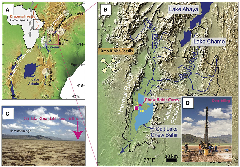
- Figure 1 - (A) Location of the drilling site amidst the Eastern African Rift System (EARS), which is home to many important fossil sites (bone symbols).
- The orange arrow shows the main northern route our ancestors took to populate the world. (B) The Chew Bahir Basin in the EARS, with the drill sites marked, where the scientists drilled 278 and 266 m into the ground of the former lake. (C) Today, the Chew Bahir Basin is only seasonally covered by a shallow salt lake. We cored during the dry season. (D) The drill rig used to obtain the long sediment cores that contain the valuable layers of sediment.
How Do Ancient Lake Sediments Store Climate Information?
Lakes like Chew Bahir are natural archives. From the moment they are formed, sediments build up at the bottom, layer by layer (Figure 2) due to erosional processes in the surrounding landscape. These erosional processes are mainly controlled by climate (precipitation, temperature, wind) and tectonics (uplift and/or sinking of the earth surface due to the earth internal power) [1]. Moreover, the vegetation growing in the vicinity of the lake produces pollen that sunk down to the lake floor and got stored there. Sediments therefore contain all kind of “proxy” information (biological, physical and chemical) about the environment and climate conditions of the past. This unique climate archive can be retrieved and interpreted through scientific drilling.
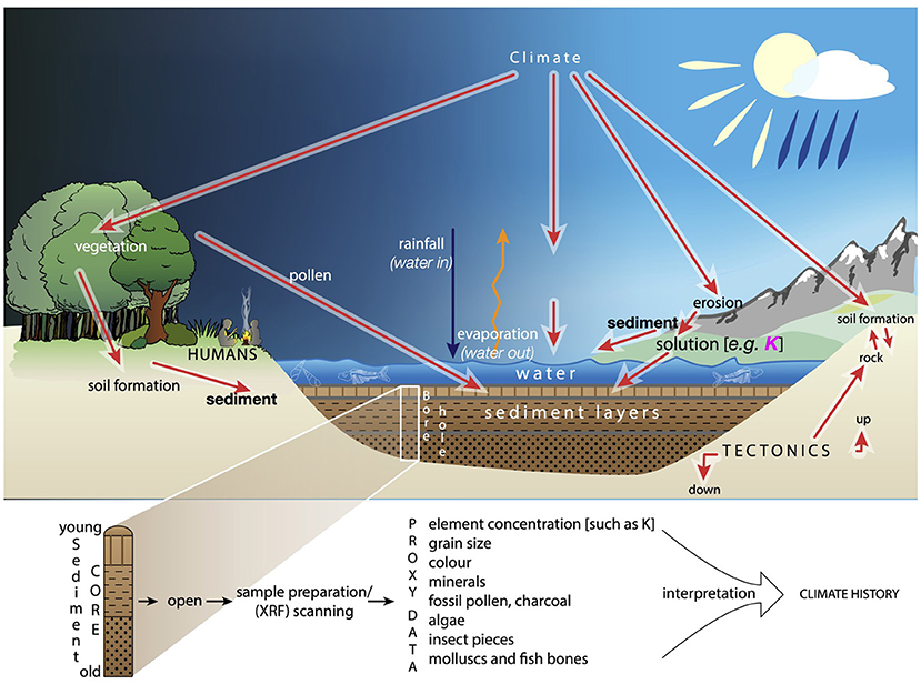
- Figure 2 - In a lake like Chew Bahir in southern Ethiopia, climate information is contained in the accumulated sediment.
- By scientific drilling, the sediment layers can be pulled up in sediment cores. Each section of the sediment can be cut open lengthwise and analyzed in the laboratory. Scientists can read the proxy data from the cores and use it to interpret patterns of climate change from the past (Figure idea by F. von Reumont).
Scientific drilling can be extremely challenging. To get sediment cores for our study, we first had to find a suitable lake and a good spot to drill deeply. Second, Chew Bahir is far away from cities, streets, running water, and electricity. We had limited time, and the entire team had to camp in the dried-out basin. So, it was quite an adventure! But our team managed to drill to depths of 278 m and 266 m by drilling day and night for 6 weeks [1]. We pulled up the sediment cores in sections that were each about 3 m long. The sections added up to about 500 m of core, weighing 3 tons! After transport to the lab, the sections were split open lengthwise for study.
“Reading” Minerals Or Fossils To Understand Past Climate
Lake sediments contain numerous climate proxies. Proxies are materials in the sediment that can be analyzed to get information about the environmental conditions at the time that they were deposited into the sediment (Figure 2). These proxies are, for example, the colors and composition of minerals, or microfossils like small crabs, algae, or pollen. Such proxies are extremely useful for reconstructing environmental history.
Potassium is the climate proxy superstar of Chew Bahir [3]. Potassium is one of 80 elements that naturally exist on Earth, and is represented by a K in the periodic table of elements. It is an important nutrient for plants. Potassium can also be used to trace past climate changes in salt lakes like Chew Bahir. When water evaporates from the lake, the lake level drops and the remaining water gets saltier. The chemical reaction that traps potassium in the sediment goes faster in saltier water. This results in higher amounts of potassium in the sediment minerals. So, high potassium values in Chew Bahir indicate intense droughts. During those dry phases, Chew Bahir shrank to small, salty puddles. Sometimes it vanished completely. Thorny shrubs and grasses replaced most plants. In contrast, low amounts of potassium in the sediment cores point to phases with lots of rainfall, which resulted in deep lakes with lush vegetation.
So, if we know the amount of potassium, we can decipher climate history! To measure potassium in our sediment cores, we used a technique called X-ray fluorescence (XRF). X-rays scanned each sediment core section, similar to looking for a broken arm in the hospital. We measured every 0.5 cm of the cores with a special XRF scanner, which gave us more than 50,000 data points! Each point told us how much potassium was in each of the measured 0.5 cm. From those potassium values, we could infer the related climate conditions at that time.
Tracking Down Past Climate Changes In Combination With Human Evolution
We could then combine the two ingredients we mentioned earlier—information about human evolution and what we knew about the region’s climate thanks to our drilling. Two things really matter when interpreting all this information. First, the intensity of the climate change is important. How wet or how dry did it get? Such conditions would mean the presence or absence of vital resources for humans, such as food and water [2]. Second, the timescale of climate change is crucial. It makes a huge difference if the environment changes a bit every year or drastically all at once [2].
Looking at the 620,000 years of eastern African climate, we can see that climate changes did not always follow the same patterns. We identified three patterns of climate variability. In Figure 3, you can see phases with sharp shifts (Phase I), soft swings (Phase II), and frequent flickers (Phase III). To figure out when the pattern of change kicked into a different phase, we used mathematical analyses. Remarkably, each phase almost coincided with key developments in human evolution (Figure 3) [4]! Starting with the oldest part of the Chew Bahir climate record (Phase I), we saw wet and rather stable climate conditions. However, this stability was interrupted by dramatic, extreme dry periods. What did this mean for our ancestors? They were probably isolated into small groups of tough survivors. Fossils found in the area reveal a remarkable diversity in hominin groups during those times. Archaic tools mostly used by our earlier ancestors also started to disappear during Phase II, and tools common to the Middle Stone Age started to appear. We know that these tools were typically used by our species, Homo sapiens, so this was a clear hint that Homo sapiens emerged on the scene during this phase.
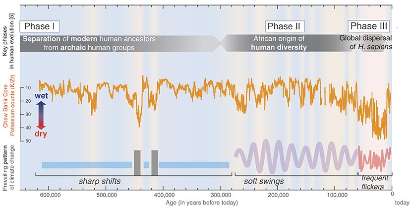
- Figure 3 - We combined what is known about human evolution from key fossil and archaeological findings with our climate record from Chew Bahir, based on potassium amounts in the sediment cores, which tell us whether the climate was wet (low quantity of potassium in the sediment) or dry (high quantity of potassium in the sediment).
- Importantly, we identified changes in the pattern of climate change and what these changes could have meant for our ancestors’ living environments. The key phases of human evolution [4] roughly fit the identified changes in climate patterns.
Around 275,000 years ago, the soft swings between wet and dry climate started to intensify. This meant that living conditions in Phase II were changing more quickly—too fast for biological evolution to keep pace! New survival strategies were needed instead. To adapt, our ancestors had new ideas for tools and they organized into groups. This was the time of cooperation, cultural advances, and long-distance material transport.
Phase III, frequent climate flickering, started to kick in about 60,000 years ago. In this phase, there were super dry extremes interspersed with a long-term drying trend. How did our ancestors manage to survive those extremely difficult conditions? Getting more and more smarter and social since the previous phase may have saved them. Phase III is also the time when our ancestors dispersed into the rest of the world, and climate flickers might have been responsible. During short, wet phases, green corridors opened up across the deserts, into Arabia [4]. Those green pathways were like the gate beyond the African continent. During short, dry flickers, our ancestors moved to higher and greener mountain areas. Archeological findings there confirm that this was a successful strategy.
So, Did Climate Change Drive Human Evolution?
We must remember, however, that human reactions are not entirely controlled by climate change. Many other factors influence our decisions, including our free will! So, there is not always a direct relationship between climate change and human evolution [5]. Our Ethiopian sediment cores show, however, that there are several patterns and levels of climate change. These important patterns range from climate chaos, with extreme flickers between desert and wetlands, to transitions that took thousands of years. The changing patterns gave our ancestors various options for dealing with their environment.
The response of our ancestors to climate changes depended on how much time they had to adapt. Long-term climate transitions occurred over several thousands of years, representing many human generations. Biological evolution also takes many thousands of years. Short-term flickers might have occurred even within a single human lifetime, causing people to respond within shorter time scales, for example by moving around and adapting their cultures. Overall, we can state, that climate changes in the past had an influence on human evolution and dispersal by setting the environmental frame and therefore creating new challenges in which human cultures could develop.
Glossary
Hominin: ↑ Our ancestors including modern and extinct humans; Hominin comprises the genus Homo that includes Homo sapiens, but also extinct ancestors in the evolutionary tree like Homo erectus.
Sediment Cores: ↑ Sample of drilled up sediment layers from beneath the earth’ surface, like lake floor, that captured the deposited material from the surrounding environment.
Boreholes: ↑ Holes in the ground that are caused by drilling and retrieving the drilled material, such as sediment cores.
Proxies: ↑ Indirect evidence, in this case in the biological, physical, and chemical indicators found in sediment cores, that can help scientists reconstruct past climate conditions and changes over time.
Drought: ↑ A phase when climate conditions are very dry for many months or years.
X-ray Fluorescence: ↑ A geochemical measuring technique that uses X-rays to determine the contents of chemical elements in a sample.
Climate Variability: ↑ Changes in atmospheric conditions, including temperature, precipitation, and wind patterns, over time periods ranging from several months to millions of years.
Conflict of Interest
The authors declare that the research was conducted in the absence of any commercial or financial relationships that could be construed as a potential conflict of interest.
Acknowledgments
We thank our colleagues of the Chew Bahir team and HSPDP initiative for the fruitful collaboration in the field, labs, and at their desks to make the original research of this paper possible. We thank the federal and regional Ethiopian authorities for issuing drilling permits in the Chew Bahir basin. We also thank the Hammar people for the local assistance during drilling operations. We thank our young reviewers for their constructive feedback and their science mentors for enabling this formidable process. Support for the Drilling Campaign and Climate Proxy Understanding Project has been provided by German Research Foundation (DFG) through the Priority Program SPP 1006 ICDP (SCHA 472/13 and /18: FS and FO 734/2: VF) and the CRC 806 Research Project ‘Our way to Europe’, project number 57444011: FS. This is publication #57 of the Hominin Sites and Paleolakes Drilling Project.
Original Source Article
↑Foerster, V., Asrat, A., Bronk Ramsey, C., Brown, E. T., Chapot, M. S., Deino, A., et al. 2022. Pleistocene climate variability in eastern Africa influenced hominin evolution. Nat. Geosci. 15:805–811. doi: 10.1038/s41561-022-01032-y
References
[1] ↑ Cohen, A. S., Campisano, C., Arrowsmith, R., Asrat, A., Behrensmeyer, A. K., Deino, A., et al. 2016. The hominin sites and paleolakes drilling project: inferring the environmental context of human evolution from eastern African rift lake deposits. Sci. Drill. 21:1–16. doi: 10.5194/sd-21-1-2016
[2] ↑ Potts, R. 2013. Hominin evolution in settings of strong environmental variability. Quat. Sci. Rev. 73:1–13. doi: 10.1016/j.quascirev.2013.04.003
[3] ↑ Foerster, V., Deocampo, D. M., Asrat, A., Günter, C., Junginger, A., Kraemer, H., et al. 2018. Towards an understanding of climate proxy formation in the Chew Bahir basin, southern Ethiopian Rift. Palaeogeogr. Palaeoclimatol. Palaeoecol. 501:111–123. doi: 10.1016/j.palaeo.2018.04.009
[4] ↑ Bergström, A., Stringer, C., Hajdinjak, M., Scerri, E. M. L., and Skoglund, P. 2021. Origins of modern human ancestry. Nature 590:229–237. doi: 10.1038/s41586-021-03244-5
[5] ↑ Faith, J. T., Du, A., Behrensmeyer, A. K., Davies, B., Patterson, D. B., Rowan, J., et al. 2021. Rethinking the ecological drivers of hominin evolution. Trends Ecol. Evol. 36:797–807. doi: 10.1016/j.tree.2021.04.011