Abstract
Strong winds mean a lot of power production by wind turbines! In the search for the windiest locations with the potential to produce lots of power, the coastal zone has popped up as one of the most appealing places. However, there are some peculiar wind patterns in coastal regions that need to be well-understood to accurately predict how much power can be produced. In this article, we will explain the mechanisms behind two of these wind patterns: the sea breeze and low-level jets.
Energy Is in the Air!
When you are outside on a stormy day, the wind can be so strong that it might blow you off your feet. Wind turbines use these strong winds to produce electricity. The wind is typically stronger along the coast and over the seas than it is inland, which makes the coastal zone an ideal place for setting up wind turbines. A small increase in wind speed results in a big increase in power production. Actually, if the wind speed doubles, the air contains eight times the energy. If wind power is generated in coastal zones, the power cables to the wind turbines do not have to be as long as they must be when wind turbines are located further out in the ocean. No wonder the coasts and ocean areas right offshore are so interesting for wind power companies! However, there are some peculiar wind phenomena that can occur in the coastal zone that are important to understand. In this article, we will have a closer look at two of them: the sea breeze and the low-level jet.
What Is Wind?
First, we must answer the obvious question: what is wind? The shortest explanation is that wind is moving air. But there is more to it. Wind is driven by pressure differences, and air flows from areas of high pressure to areas of low pressure. Imagine blowing up a balloon: the air pressure inside the balloon is higher than outside the balloon. If you hold the balloon between your hands and untie the knot, there will be a stream of air directed out of the balloon—a wind! Likewise, in the environment, wind blows from areas of higher pressure toward areas of lower pressure. In meteorology, we usually consider winds that are larger than those generated from a balloon. We can study anything from huge, continent–sized pressure systems down to local effects, such as how the wind is affected by houses and streets within cities. At an even smaller scale, we can study the turbulent motions in the smoke above a fire.
When wind blows close to the Earth’s surface, it is slowed down by a force known as friction. The more obstacles on the ground, the higher the friction. Over land, the wind experiences obstacles such as trees, houses, hills, and mountains. However, the ocean is much smoother. Thus, with the same pressure difference, the wind will be stronger over the ocean compared to over land—because there is less friction to resist the air flow.
The Sea Breeze
Picture a beautiful summer’s day at the coast. The surface of the water looks as smooth as glass, the sun is brightly shining, and the temperature is rapidly increasing. Around lunch time, you look inland and see some majestic clouds forming; but over the sea, the skies are still clear. All of a sudden, you feel the gentle touch of a weak breeze, bringing slightly cooler and fresher air from the sea. The breeze grows stronger during the afternoon, but weakens toward the evening. At the same time, it looks like all the clouds over the land have disappeared. What is going on?
The phenomenon you have observed is called the sea breeze [1]. During the day, the air warms quicker over land than it does over the sea, so the air over land will rise. This is because warm air is lighter than cold air—think of how a hot air balloon works! The rising air creates an area of low pressure over land, and cooler air from the sea—where the pressure is relatively higher—will start to move over land to fill this gap. This air movement creates the breeze you felt! However, a few hundred meters up in the atmosphere, the winds will be in the opposite direction (Figure 1). This happens because the rising air increases the pressure at this height over land, but the sinking air decreases the pressure at this height over the ocean. Over land, the rising air brings moisture up into the atmosphere and, as the air cools, the water vapor condenses and clouds start to form. If the conditions are just right, there can be some local showers or even thunder! In the afternoon and evening, as the sun starts to set, the land cools and there is less warm air rising from the land to keep the circulation alive—so the sea breeze weakens. During the night, the air movement can even flip completely, as the sea surface is warmer than the land. Remember, just as the land heats faster than the ocean, the land also cools faster. At low levels, the wind will then be directed from land toward the sea and—you guessed it—this is fittingly called the land breeze.
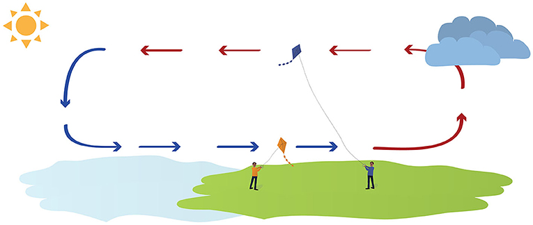
- Figure 1 - On a sunny summer’s day, the sea breeze creates a circulation of the air along the coast, as indicated by the arrows (blue: cooler air, red: warmer air).
- The wind is directed toward land at low levels but away from land higher up. Thus, the lower orange kite and the higher blue kite are pulling in opposite directions. Further inland, upward motion of air is beneficial for cloud formation. Over the sea, however, the air descends, which counteracts cloud formation so the weather remains sunny.
Low-level Jets
Low-level jets are another special type of wind that often appears over coastal waters. These are strange looking wind profiles (that is, how the wind speed changes with height) with a maximum speed at maybe 50–300 m height (Figure 2). This is quite different from a normal wind profile, in which the wind speed slowly increases with height! There are many processes that can cause the jets [2]. One example is during spring and summer, when the wind blows warm air from land over ocean waters that have still not heated up after the winter. The warmer air from land flows on top of the colder ocean air and speeds up, because the boundary between the two air masses is almost free from friction—almost as if the upper air is slipping!
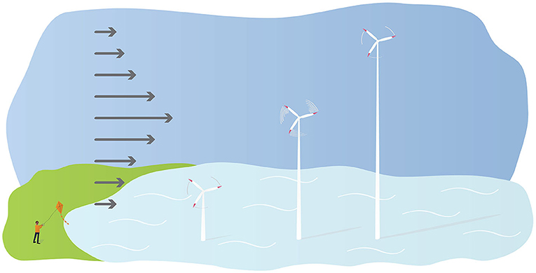
- Figure 2 - Normally, wind speed gradually increases with height but, during a low-level jet, the strongest winds are present at heights between 50 and 300 m height (longest arrows).
- This happens because the upper air is detached from the lower air and can start to speed up. Low-level jets also affect the power production from wind turbines and, in the figure, the wind turbine at the center of the jet experiences much stronger winds than both the shorter and taller turbines. Thus, it rotates faster and produces more electricity.
What Do these Wind Effects Mean for Wind Power?
Both the sea breeze and low-level jets occur at heights that can affect the generation of wind power, so it is very important to take these effects into consideration when planning wind farms in the coastal zone [3, 4]. In an optimal location, the sea breeze and low-level jets can help to boost the power production, which of course is highly desirable! To know exactly where to place the turbines we need computer models. However, if the models used to describe the wind climate cannot capture these wind phenomena, the power output from the turbines could be incorrectly estimated. This can cause unexpected increases or drops in the electricity generation. In the worst case this can result in a power outage so that you cannot turn on the lights at home for a few hours.
Summary
In general, the wind over the ocean is stronger than the wind over land. In coastal zones, the wind has its own characteristic features. Two of the most peculiar phenomena regularly seen in coastal zones in spring and summer are the sea breeze and low-level jets, both of which are important for wind power production. Researchers are currently trying to better understand all the details of these winds, so that they will be able to accurately capture their effects in computer models [2, 5, 6]. Such research will help meteorologists to both properly describe a region’s long-term wind climate and to improve short-term power production forecasts. But one thing is clear: the wind blows in favor of wind power in the coastal zone!
Glossary
Coastal Zone: ↑ The area that starts at the coast and extends a few kilometers inward over land and a few kilometers outward over the water.
Sea Breeze: ↑ A circulation of winds often occurring at the coast, caused by temperature differences between the warmer land the cooler sea. Typically, the sea breeze occurs in summer during the day.
Low-level Jet: ↑ Increasing wind speed at a few hundred meters height. Low-level jets often appear over the sea in summer when the upper air detaches from the lower air and speeds up.
Meteorology: ↑ The science of the weather and how temperature, winds, rain and clouds behave and how they are connected.
Friction: ↑ The resistance to wind flow over surfaces. The rougher a surface is, the more it will slow down the wind.
Land Breeze: ↑ When the sea is warmer than the land surface, a land breeze blowing from land toward the sea can appear. Typically, this happens in summer during the night.
Wind Profile: ↑ A description of how the wind speed changes with height.
Computer Model: ↑ Using computers meteorologists can create models of the atmosphere to better understand and predict wind patterns. The models are based on physical explanations about movements and interactions in the atmosphere.
Acknowledgments
This work was funded by the Energimyndigheten (Swedish Energy Agency) VindEl program, Grant Number 47054-1. The work forms part of the Swedish Strategic Research Program StandUp for Wind.
Conflict of Interest
The authors declare that the research was conducted in the absence of any commercial or financial relationships that could be construed as a potential conflict of interest.
References
[1] ↑ Miller, S. T. K., Keim, B. D., Talbot, R. W., and Mao, H. 2003. Sea breeze: structure, forecasting, and impacts. Rev. Geophys. 41:1–31. doi: 10.1029/2003RG000124
[2] ↑ Hallgren, C., Arnqvist, J., Nilsson, E., Ivanell, S., Shapkalijevski, M., Thomasson, A., et al. 2022. Classification and properties of non-idealized coastal wind profiles–an observational study. Wind Energy Sci. 7:1183–207. doi: 10.5194/wes-7-1183-2022
[3] ↑ Steele, C. J., Dorling, S. R., von Glasow, R., and Bacon, J. 2015. Modelling sea-breeze climatologies and interactions on coasts in the southern North Sea: implications for offshore wind energy. Q. J. R. Meteorol. Soc. 141:1821–35. doi: 10.1002/qj.2484
[4] ↑ Aird, J. A., Barthelmie, R. J., Shepherd, T. J., and Pryor, S. C. 2022. Occurrence of low-level jets over the eastern us coastal zone at heights relevant to wind energy. Energies 15:445. doi: 10.3390/en15020445
[5] ↑ Hallgren, C., Arnqvist, J., Ivanell, S., Körnich, H., Vakkari, V., and Sahlée, E. 2020. Looking for an offshore low-level jet champion among recent reanalyses: a tight race over the Baltic Sea. Energies 13 :3670. doi: 10.3390/en13143670
[6] ↑ Xia, G., Draxl, C., Optis, M., and Redfern, S. 2021. Detecting and characterizing sea breezes over the US Northeast Coast with implication for offshore wind energy. Wind Energy Sci. 7:815–29. doi: 10.5194/wes-7-815-2022