Abstract
Imagine a fisherman back in 1726 who relied on catching fish to survive and support his family. When the number of fish went down for any reason, the family would suffer. In 1726, a change in the sea-surface temperature of the Pacific Ocean, which lasted many months, decreased the number of fish. Since then, similar observations have been made in the Pacific Ocean close to the equator. Today, the reasons for the changes in sea temperature are known as the El Niño-Southern Oscillation. It has been studied scientifically since the 1900s. But what is this circulation? In this article, we will explore it in detail and describe its relationship to changes in the environment.
The energy that travels to Earth from the sun is the main driver of Earth’s climate. Near the equator, warming by the sun is much stronger than it is in polar regions. These large differences in climate conditions around the globe cause air movements in the atmosphere. For example, near the equator, the high temperatures from the sun cause the air to rise [1]. These air movements ultimately result in changes in weather and climate.
How Does Warm Air Rise?
Warm air is lighter than cold air. Imagine you have two balloons, one filled with warm air and the other filled with cold air. The balloon filled with warm air will float up into the sky, while the balloon filled with cold air will fall down to the ground. Similarly, if the air near the ground is warmer and lighter than the air above it, it will rise. This is why hot air balloons rise up high into the sky—the warm air inside the balloon is lighter than the colder air outside, so it lifts the balloon upwards. In the atmosphere, the rising air starts a circulation pattern: when the warm air leaves the Earth’s surface, new air must replace it. The replacement air usually comes from colder regions, in the form of winds that blow over the ground. This circulation in the atmosphere creates winds that blow from east to west near the equator, which are called trade winds [1].
What Happens in the Pacific Ocean?
The Pacific Ocean lies between America and Asia/Australia (Figure 1). Close to the equator, the trade winds blow over the sea surface of the Pacific Ocean and push sea water westwards, toward Indonesia. As with the air, the water in the east, close to South America, cannot just vanish, but must be replaced. Therefore, to keep the balance, colder water from the deep ocean rises near the coast of South America. The deeper down in the ocean, the colder the water is. You might know this from a swimming pool—sometimes the water at the surface is nice and warm, but your feet can still be in cooler water. The water that rises to the surface of the Pacific is colder than the surrounding water at the ocean surface, which creates a strong temperature difference (Figure 2). The cold water from the sea floor is also rich in nutrients, which can feed lots of fish. Fishermen are glad because there are a lot of fish to catch. Due to this process, the temperature at the surface in the eastern Pacific is around 20°C, while the western Pacific waters can be up to 30°C—a difference of about 10°C.
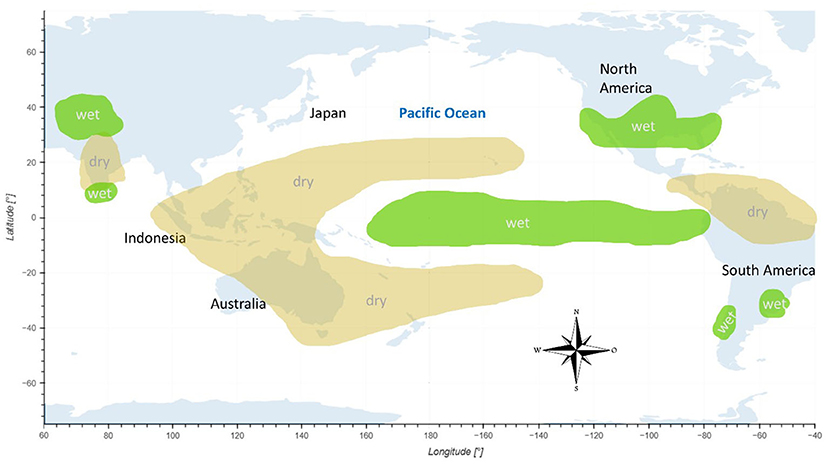
- Figure 1 - The El Niño-Southern Oscillation occurs in the Pacific Ocean, between South America in the east and Indonesia and Australia in the west.
- Green areas indicate where the air is wetter than usual (where it can rain more often, for example) at certain times of the year. Yellow areas show where the air is drier than usual at certain times of the year (Map created using the Python library for interactive visualization; compass image from Pixabay).
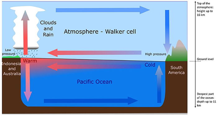
- Figure 2 - In the Pacific Ocean near the equator, the atmospheric circulation affects the movements of air and ocean water.
- Blue arrows indicate cold air and water; red arrows indicate warm air/water. Air sinks in the high-pressure region and rises in the low-pressure region. The rising air forms clouds and rain. The Walker circulation shown here represents the “normal” situation.
Why Is the Temperature Difference Important?
The warm temperatures of the surface ocean in the western Pacific warm the air above it, causing the air to rise. As the warm air rises, it gets colder. Cold air cannot hold as much water vapor as warm air, so the water vapor in the air turns into tiny water droplets that stick together, form clouds, and eventually fall as rain. In areas of colder water in the eastern Pacific near South America, the cooler air sinks. When air sinks, it becomes warmer (the opposite of what was described above) and squeezes out all the water droplets. The water evaporates and disappears, which makes the air dry and does not produce any rain [1]. These characteristics match the environmental conditions: rainforests in Indonesia and deserts in the western parts of South America.
The rising air in western regions of the Pacific Ocean moves eastward, high in the atmosphere, in the direction of South America. The sinking air in the eastern regions (South America) is carried westward, near the ground. This movement of air is called the Walker circulation (Figure 2).
The El Niño-Southern Oscillation
What you have just learnt about the Walker circulation and its interaction with the ocean is called the El Niño-Southern Oscillation phenomenon. A phenomenon is an event that can be observed and studied. Phenomena can range from simple everyday occurrences, like the rising and setting of the sun, to complex natural events, like the one that we are presenting to you here. The term “oscillation” describes weather patterns that move back and forth in a regular rhythm. The El Niño-Southern Oscillation occurs over a period of 1–10 years [1].
If we consider the Walker circulation of the El Niño-Southern Oscillation to be the “normal” state, there are two other possible states that can occur: El Niño and La Niña. These states happen when there are changes to the surface temperature of the ocean, which can change the Walker circulation. If the eastern Pacific gets warmer, we are in the El Niño state (Figures 3A, B). El Niño means “little boy” in Spanish and the term comes from Peruvian fishermen. The “little boy” refers to baby Jesus, said to be born on Christmas—around the time when the eastern Pacific surface temperatures might heat up. In contrast, when we are in La Niña, which means “little girl,” when the eastern Pacific is unusually cold.
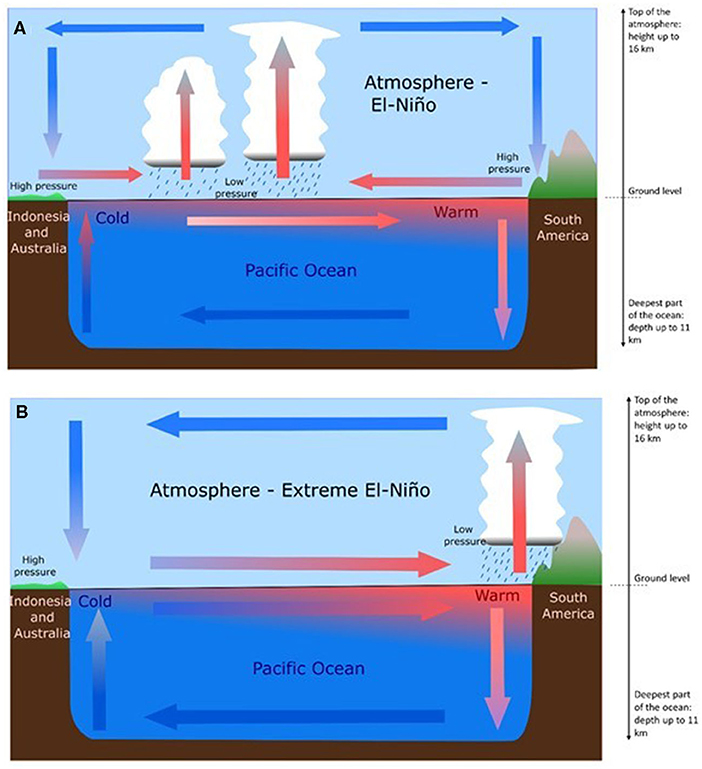
- Figure 3 - (A) During the El Niño state, the Walker circulation weakens due to a shift in the atmospheric pressure and partly reverses its direction.
- Most of the clouds and rain form over the open ocean. Thinner arrows indicate a weaker circulation. (B) In an extreme El-Niño state, which happens when we have a low-pressure system over South America, the Walker circulation flips its direction completely. The areas of dry, sinking air and wet, rising air switch from one end of the Pacific Ocean to the other. This causes the Eastern Pacific to heat at its surface.
The El Niño State
During the El Niño state, the surface air pressure in the eastern Pacific (sinking air) and lower surface air pressure in the western Pacific (rising air) are weakened. This weakens the Walker circulation, so the air movement is not as strong as it is under normal conditions. This weakened circulation weakens the trade winds, which can even change their direction completely (Figure 3A).
The weaker Walker circulation can affect the ocean currents, because the trade winds move the surface water—like when you blow into a cup of tea. The changes in the trade winds cause warm water at the ocean surface to be moved from the western Pacific eastward to the coast of South America. This change in the ocean surface temperature has several effects [2]: cold water from the deep ocean does not rise to the surface in the eastern Pacific. Since deep ocean water is also rich in nutrients, fish do not get enough to eat and the fish population decreases, which is bad for fishermen.
But this is not all! El Niño causes heavy rains in the eastern Pacific and parts of South America and increases hurricanes in Central America (e.g., Mexico) [3]. In Indonesia and other parts of the western Pacific, El Niño increases droughts (Figure 3A). The El Niño phenomenon appears every 3–8 years.
Sometimes El Niño can be extreme, and the Walker circulation can flip its direction completely, leading to a low-pressure system over South America, bringing clouds and heavy rain to an area that is not used to these weather conditions. At the same time, Southeast Asia experiences a high-pressure system without rain. The results are flooding in South America and drought in Indonesia and Australia. This is particularly dangerous in Australia because it can lead to wildfires (Figure 3B).
La Niña State
La Niña occurs when the eastern Pacific is cold, causing very low surface air pressure (rising air) in the western Pacific and high surface air pressure (sinking air) in the eastern Pacific (Figure 2). The difference between the surface air pressure in the east and west is much higher than the normal state, so the trade winds are stronger. Stronger trade winds can move more surface water from the eastern to the western Pacific and, in the eastern Pacific, cold, nutrient-rich water from the deep ocean can rise to the surface. The cold water can spread on the surface of the ocean from the eastern Pacific to the far west. That is the reason why La Niña is also known as the cold phase of the El Niño-Southern Oscillation. During this time, a lot of rain falls in Indonesia and South America is very dry. Thus, floods are likely in North Australia/Indonesia and droughts are likely in South America. La Niña occurs every 3–5 years.
Problems and Effects
El Niño and La Niña influence the lives of millions of people around the world. They define how much rain falls, which can greatly affect the lives of farmers and create either droughts and forest fires or, at the other extreme, severe rain falls and floods. Extreme conditions can affect food production and the availability (and cleanliness) of drinking water. El Niño also affects the number of fish fishermen can catch, and even how many people get sick, because they might not have enough to eat. During a severe El Niño in 1997–1998, around 23,000 people died from the effects of the environmental conditions, such as 2016 and expected for 2023/2024.
It is important for scientists to continue studying the El Niño-Southern Oscillation, for understanding and predicting when extreme situations might happen. This can help us to better prepare for its impacts, which could save lives. For example, people could prepare their houses for heavy rainfall, or forest fires, or save food for times when farming or fishing might not be possible. The El Niño-Southern Oscillation is an important climatic phenomenon that shows the delicate balance of Earth’s climate, significantly impacting both marine life and human activities.
Glossary
Trade Winds: ↑ Trade winds are strong, steady winds that blow near the Earth’s equator. They help move ships on the sea and affect the weather in many countries.
Walker Circulation: ↑ The Walker circulation is a pattern of winds across the tropical Pacific Ocean, where air rises, travels, falls, and returns, greatly influencing the weather in those regions.
El Niño-Southern Oscillation: ↑ El Niño-Southern Oscillation is a natural event where Pacific Ocean temperatures change, causing different weather patterns like more rain or dry conditions in various parts of the world.
El Niño: ↑ El Niño is a time when the Pacific Ocean gets warmer, making weather around the world change, like bringing less rain to Australia and South-East Asia.
La Niña: ↑ La Niña is when the Pacific Ocean gets cooler than usual, leading to wetter conditions in Asia and Australia, and drier, cooler weather in the Americas.
Low-Pressure System: ↑ An area where the air pressure is lower than in the surrounding areas.
Conflict of Interest
The authors declare that the research was conducted in the absence of any commercial or financial relationships that could be construed as a potential conflict of interest.
References
[1] ↑ Ross, A. 2000. The Fisherman’s Ocean: How Marine Science Can Help You Find and Catch More Fish. Mechanicsburg, PA: Stackpole Books.
[2] ↑ Kevin E. 1997. Trenberth “the definition of El Niño”. Bull. Am. Meteorol. Soc. 78:2771–7.
[3] ↑ Pielke Jr, R. A., and Landsea, C. N. 1999. “La Niña, El Niño, and Atlantic Hurricane damages in the United States. Bull. Am. Meteorol. Soc. 80:2027–34.