Abstract
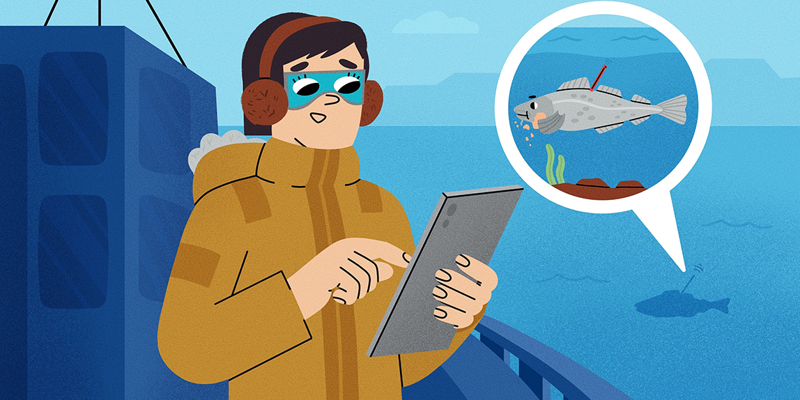
Have you ever lost your phone and used its GPS function to locate it? To learn about fish, scientists are interested in where fish go and what they experience but GPS technology does not work underwater. Scientists therefore developed small electronic data loggers that can be attached to fish, to record conditions in a fish’s environment. When the fish is recaptured, this information can be downloaded and returned to the scientists. The fish’s movements can then be reconstructed by comparing the recorded measurements with the conditions in the sea. In this article, we explain how this method works and tell you the story of two cod with very different fates: Wally, who moved around to feed and to produce offspring, and Wilma, who went on an adventure with a surprising ending.
Why Do Fish Move and Why Should We Learn About It?
Have you ever lost your phone? If so, an app that tracks your phone’s position may have helped you locate it. Tracking apps use a global positioning system (GPS), based on satellite signals. For animals that live on land, this method can be used to follow their movements and learn more about their behavior. Tracking an animal’s movement can tell us many things—both about the lives of single individuals and about whole populations [1].
This article will focus on the movements of fish, because harvesting of fish around the world provides jobs and a source of food for millions of people. If we want to continue to harvest and eat fish in the future, fish populations must be managed sustainably. Sustainable fisheries management benefits from knowledge about where fish live, what they eat, how fast they grow, and what causes them to die.
To learn more about fish, scientists are interested in understanding where individual fish go during their lives and what environments they experience (to learn even more about how scientists study fish movements, see this Frontiers for Young Minds article). Are the fish on their way to meet a partner to reproduce? Where do they feed? Where do they find shelter? How do environmental factors, such as water temperature, affect their actions (see also this Frontiers for Young Mind article)? In contrast to humans, fish can move in three dimensions, so they can potentially use the whole water column from the water surface to the sea bottom as their habitat. The water column consists of several layers of water that vary in temperature, salinity, and oxygen content, among other characteristics.
How Can We Track Fish?
Can we simply equip fish with small GPS sensors, so that we can follow them in their environments? This is done for mammals living on land, birds and whales—animals that live on land, in the air or regularly need to come close to the water surface to breath. Unfortunately, GPS technology does not work for tracking things underwater (Figure 1). It is therefore not yet possible to track fish directly and continuously in the sea. But scientists have come up with a clever alternative: they have developed small electronic devices called data storage tags (DSTs), which record the conditions of the environment the fish is swimming in—like temperature, depth, and salinity. DSTs have been used since the 1990s and the technology keeps advancing [2]. DSTs can be attached to the fish or implanted in their body cavity with a quick surgery (Figure 1). Further, an external tag with a telephone number and a unique identification number is attached to the fish, so fishers know who to contact when the fish is caught. Scientists record the time and location of the fish’s release as well as the size of the fish. Upon release, the fish resumes life in its natural environment.
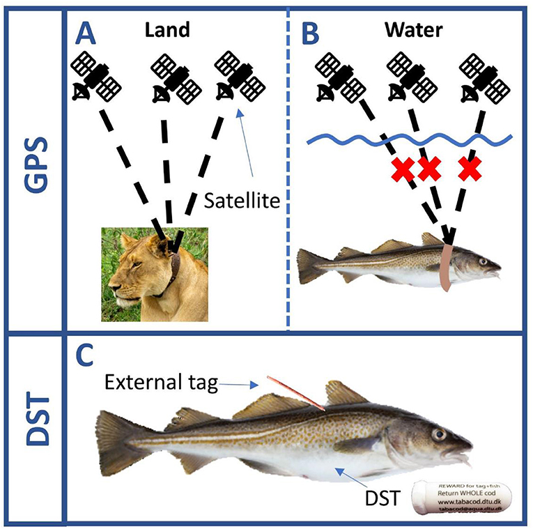
- Figure 1 - (A) The movement of animals living on land can be followed using GPS collars.
- (B) GPS signals are quickly absorbed by water, so this technology does not work for fish. (C) As an alternative, fish are tagged (internally, in this case) with DSTs that record information about the environment, such as temperature and depth. We used DSTs that are 25.4 mm long, with a diameter of 8.3 mm. Since the DSTs are not visible from the outside, external tags are used so that fishers recognize that they should contact us and send the fish back to us.
Reconstructing the Movement of Fish
When the fish is recaptured by fishers and returned to the scientists, the information recorded in the DSTs can be downloaded. The movements of the fish between release and recapture can then be reconstructed by comparing the recorded measurements with the conditions in the sea. Computer models, which are like 3-dimensional maps of the ocean, provide details about ocean conditions such as the temperature for each depth at each position. These computer models are 3-dimensional because, as we mentioned, fish can swim up and down in the water column.
Scientists can use the ocean data in the computer model to reconstruct the most likely track a fish swam between release and recapture. Areas with temperature and depth values similar to the recorded measurements on the DST are assigned the highest probability that the fish was at that position. For each day between release and recapture, the most likely area the fish was in is identified in this way. Depending on the species, fish can swim only a certain distance each day. A shark, for example, can swim much further than a clownfish. Positions too far away from the previous day’s location can therefore be excluded. These calculations are done by a computer that works with a complicated code written by the scientists. Even with the right code, it takes the computer several hours to reconstruct the track of a single fish that recorded data for one year.
Wally—A Life of Feeding and Reproduction
We will now tell you about two DST-tagged fish—two cod that lived in the Baltic Sea and whose stories we reconstructed. The first cod, Wally, swam freely for over a year after tagging, and was finally recaptured by a fisher. The fisher told us the location where Wally was caught and sent it to us. We found out that Wally was a male cod and that he grew less than 3 cm during the year since being tagged and released (from 32.8 to 35.7 cm), which is not much for a cod. Wally was released by a tagging team on April 4th, 2017, close to the German island of Rügen (Figure 2). Soon after release, he moved into deeper waters and in May arrived at Bornholm Basin, the spawning ground where cod in that area mate. Wally stayed in the spawning ground until the end of August and, although the Bornholm Basin is around 100 m deep, he stayed in the middle of the water column, at around 60–75 m depth. He then went closer to the island of Bornholm, likely to use the steep slopes to search for food. If you look closely, you can see how he swam up and down several meters on multiple days, which resulted in large temperature variations (Figure 2). Before Wally was recaptured on April 17th, 2018, he spent several months in the southern part of the Arkona Basin. During this time herring, one of the favorite prey of cod, move into the shallower lagoons of the island of Rügen to spawn, and cod follow them. You can see that Wally was recaptured only 15 km away from his release position. Without the DST recording depth and temperature, we would not have known that Wally swam 1,255 km over that year—an average of 3.3 km per day.
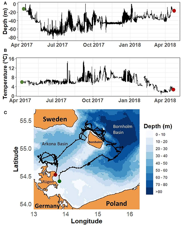
- Figure 2 - (A) Depths and (B) temperatures experienced by a cod we named Wally, released in April 2017 (green dots) and recaptured in April 2018 (red dots).
- (C) Wally’s reconstructed path between release (green dot) and recapture (red dot). The black dots represent Wally’s daily positions. The Bornholm Basin is a known spawning ground for cod, and the Arkona Basin and shallow coastal areas around Rügen are popular feeding grounds.
Wilma—An Unexpected Ending!
Another cod, Wilma, did not have a chance to move to the spawning ground. Wilma was released when she was 38.5 cm long, on February 7th, 2018, close to the island of Rügen (Figure 3). Wilma was not returned to us by a fisher, but instead by a scientist studying birds. He found the DST in December 2018 in a cormorant colony [3]. Cormorants feed on fish but regurgitate (throw up) parts of their food that cannot be digested. The DST-tagged cod was fully digested and therefore we have no information about Wilma’s size when she was eaten. When we analyzed the DST data, we found that Wilma stayed in shallower water than Wally did—she did not swim deeper than 38 m. She most likely roamed the shallow, coastal areas for food. On May 8th, 90 days after her release, Wilma moved from around 20 m deep into very shallow water, where she was eaten by a cormorant. You can see in the temperature profile that she was digested at the cormorant’s body temperature of around 40°C. Since we do not know where Wilma was lifted out of the water, we can only approximate the track between release and recapture. The depth profile strongly suggests that Wilma stayed within the southern Arkona Basin and regularly returned to the shallow coast of the island of Rügen, where the cormorant colony is located. This very special recapture helped us to learn about the interaction between cod and cormorants.
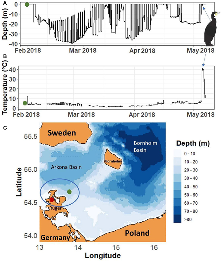
- Figure 3 - (A) Depths and (B) temperatures experienced by a cod we named Wilma, released in February 2018 (green dots) and eaten by a cormorant in May 2018 (blue arrows).
- (C) Release position (green dot) and position of the cormorant colony where the bird scientist found the DST in December 2018 (red dot). We were unable to reconstruct Wilma’s track due to a missing recapture position but we assume, based on the depth data from the DST, that Wilma stayed within the area indicated by the blue circle.
Summary
Tracking individual fish in the sea is challenging, but now you know about a method using small electronic data loggers that can help scientists learn more about the behavior of individual fish—specifically, where they go and what environmental conditions they experience. Monitoring the behavior of single fish helps us to detect patterns of entire fish populations. This can enable us to harvest fish more sustainably, by identifying ocean areas that need to be protected, detecting how fish populations react to climate change, or by discovering how fishing influences fish populations. These studies will help us to make sure fish populations are still around for many future generations.
Glossary
Global Positioning System (GPS): ↑ A system that uses satellites that send signals about their locations to earth. From these signals, the position of a receiver unit, such as a phone, can be determined.
Sustainable Fisheries Management: ↑ Fishing that is done carefully, at a level that ensures that the fish population will remain productive and healthy so that it can be fished indefinitely.
Water Column: ↑ It is the space between water surface and sea floor.
Salinity: ↑ Contrary to freshwater, the water in the oceans contains salt. The amount of salt in the water is referred to as salinity. The more salt in the water, the higher the salinity.
Data Storage Tag (DST): ↑ A data logger that can be attached externally or implanted internally into fish. It records data at predefined time intervals, which can be downloaded after retrieval.
Spawning Ground: ↑ Many fish species move to specific areas in the ocean to meet partners and to reproduce. Fish lay eggs, which is termed “spawning” The areas fish move to are called spawning grounds.
Conflict of Interest
The authors declare that the research was conducted in the absence of any commercial or financial relationships that could be construed as a potential conflict of interest.
Acknowledgments
This article arose from research under the Tagging Baltic cod (TABACOD) project which was funded by BalticSea2020 (http://balticsea2020.org). We thank the fisher and ornithologist who returned the data storage tags and Ulf Gräwe (Leibniz-Institute for Baltic Sea Research, Warnemünde, Germany) for providing the regional ocean model.
References
[1] ↑ Dingle, H. 2014. Migration: The Biology of Life on the Move. Oxford: Oxford University Press. p. 352.
[2] ↑ Hussey, N. E., Kessel, S. T., Aarestrup, K., Cooke, S. J., Cowley, P. D., Fisk, A. T., et al. 2015. Aquatic animal telemetry: a panoramic window into the underwater world. Science 348:6240. doi: 10.1126/science.1255642
[3] ↑ Haase, S., Hüssy, K., Casini, M,. Radtke, K., and Krumme, U. 2021. “Eaten by a cormorant: unexpected return of a tagged Baltic cod,” in IEEE International Workshop on Metrology for the Sea; Learning to Measure Sea Health Parameters (MetroSea) (IEEE). p. 283–287