Abstract
The Sacramento-San Joaquin Delta of California was largely shaped, and is maintained by, an immense amount of human activity. Evidence of this activity can be felt everywhere in the Delta, from rock-lined levees to the straight channels, from the non-native fish and plant species to the amount of water that flows through the Delta and where that water goes. How the Delta looks, feels, smells, and functions also impacts the people who live, work, and play in the Delta, and who drink or eat crops grown with Delta water. This article will explore how people have made the Delta and how the Delta influences people’s lives, both within and beyond this unique region.
Where Two Rivers Meet the Ocean
The Sacramento-San Joaquin Delta is part of the largest estuary on the west coast of North America, the San Francisco Bay Delta. This beautiful and unique water body formed where the Sacramento River and San Joaquin River join and flow into the salty San Francisco Bay. The Delta teaches us important lessons about how people change landscapes and how those landscapes change people.
The Sacramento and San Joaquin Rivers are the two largest rivers in the state of California. Their combined watershed covers nearly half of the state, including many smaller rivers and streams flowing out of the Sierra Nevada mountains and Coastal Range (Figure 1) [1]. The Sacramento-San Joaquin Delta refers to the area where these two rivers split into multiple smaller channels and meet—bringing water, fish, and sediments such as sand, silt, and gravel [2].
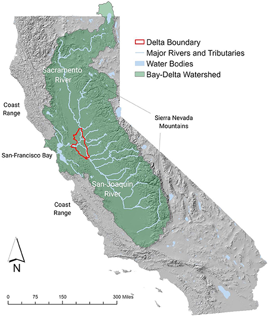
- Figure 1 - Map of California showing the Sacramento-San Joaquin Delta Watershed (Image credit: Alejo Kraus-Polk).
Deltas form as rivers slow down and empty water and sediment into an ocean, lake, or another river. As sediments in deltas build up over time, rivers must shift, and often split into many channels, giving deltas their typical fan shape. The Sacramento-San Joaquin Delta (or “Delta,” for short) is different, in that it is a classic example of an inverted delta. After the rivers split into smaller channels, these channels meet again to flow through a single gap in the Coastal Range into the San Francisco Bay and, eventually, into the Pacific Ocean [2]. The Delta wasn’t always like this. Fifteen thousand years ago, when sea levels were much lower during the last Ice Age, the Delta formed in what is now ocean, west of the San Francisco Bay. As sea levels rose over thousands of years, the Delta migrated toward its present location and became an inverted delta [3].
California Indians lived through this significant change, but they had plenty of time to adapt. A large population of California Indians inhabited the Delta. These early inhabitants modified and maintained the Delta landscape through hunting, fishing, tending desirable plants, and intentionally setting fire to grasslands and forest understory to promote the growth of traditional food sources. California Indians continue to live in and around the Delta.
How Immigrants Changed the Delta
In the last 200 years, the Delta has been changed considerably by the activities of newly arrived people. The first wave of immigrants traveled through the Delta in the 1850s, seeking gold in the mountains [2]. However, the chances of striking it rich were small. Some people realized that farming Delta’s fertile soils might be more promising. The problem was that the Delta was a naturally low-lying marshland and flooded nearly every winter. Sometimes the floods were so large that California’s entire Central Valley would become a vast “inland sea” [4]. These floods made farming and building houses and cities a risky idea. However, the sediment deposited by floodwaters helped create the fertile soils that made farming in the region so attractive.
To make the Delta farmable required draining marshes and protecting these “reclaimed” lands from flooding. Immigrants from the Pearl River Delta in China, who had experience draining marshes for farming, did much of this work. They built levees, which are mounds of earth on the edge of rivers and channels, and they dug drainage ditches with shovels and wheelbarrows [5]. Unfortunately, big floods could easily undo all that hard work.
At first, there were no large machines to help, but eventually, large machines, such as the clamshell dredge, were invented. Machines made it possible to build larger levees that prevented floods from washing away farms and houses (Figure 2). The levees were made stronger by gravel washed down from the Sierra Nevada mountains, where hydraulic gold mining was taking place [5]. As the levees became stronger, people made more farms and houses and eventually cities, such as Sacramento, California’s capital. However, building levees and draining marshes eliminated nearly all the habitat for the birds, fish, and mammals that had flourished there, either as year-round residents or seasonal migrants. The populations of these animal species, some of them unique to the area, fell significantly [3]. Meanwhile, the farmland area continued to increase, along with the sizes of nearby cities and towns [5].
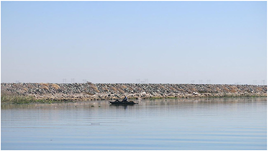
- Figure 2 - A modern delta levee, designed to keep rivers from flooding the surrounding lands (Photograph credit: Alejo Kraus-Polk).
Even though the levees were bigger, flooding was still a problem. When it snowed and rained a lot in the winter, there was not enough room in the rivers to hold the water. While the levees kept farms from flooding most of the time, they also made water levels in the river rise dangerously and, when levees broke, it was disastrous for the same farmland and towns the levees were built to protect [5]. In the early 1900s, the government built dams to capture snowmelt before it rushed into the rivers. The government also set aside areas where the rivers could flood, and no cities could be built [4]. The government also built some larger levees that were less likely to break, but these also increased the risk for those places with smaller levees.
Moving Delta Water
The early 1900s also saw farming and cities growing in places far away from the Delta. Some of these growing areas, unlike the Delta, lacked the water necessary for living and working. Some places without enough water began pumping water from underground, but this was expensive, the water was sometimes salty, and sometimes the process even caused the ground to sink. People in these areas needed more freshwater, and they looked to the Delta.
Moving water from the Delta to far-away areas meant building long aqueducts and huge pumps, an expensive job that the government began in the mid-1900s. At first, it seemed like both the people in the Delta and those far away would be better off. However, once water could be moved from the Delta, the far-away areas became dependent on that water. During rainy years, cities and farms could get more water, and they began to expect the same amount of water even in drought years. Over time, it became clear that taking water from the Delta, especially in dry years, had damaging consequences for the Delta environment, including its cities, towns, and farms [1, 3].
One significant consequence of taking fresh river water from the Delta is that saltwater from the San Francisco Bay flows in. This saltier water affects fish, plants, other species, and the farms, towns, and cities that rely on fresh Delta water. The huge pumps that move water from the Delta can also reverse the natural direction of the Delta’s rivers, which can confuse the fish. In addition to the water pumped out of the Delta, water is taken out of the Sacramento and San Joaquin rivers before they reach the Delta, for use by upstream farms and cities. Some of this water returns to the river more polluted, further threatening the fish and other users of Delta water [3].
Water has become a point of conflict between supporting the Delta’s health and serving those outside the region who have come to depend on it. Many laws and programs have been put in place to balance those needs while also protecting the Delta’s unique culture and character [2]. In addition to balancing water needs, these efforts also attempt to restore some of the lost habitats and fish species on the edge of extinction, such as the Delta smelt (Figure 3).
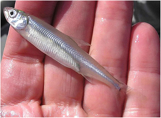
- Figure 3 - Critically endangered Delta smelt (Photograph credit: Peter Johnsen, U.S. Fish and Wildlife Service).
Today’s Delta does not look, smell, feel, or function at all like the Delta that the first gold seekers encountered. The marshland—then one of the largest in North America—is almost entirely gone, along with fish, bird, and mammal life. New fish and plants have been brought into the Delta from far away. Delta channels that used to move around have now been straightened and fixed in place with rock-lined levees. The islands created by those channels have lost soil and sunk to below sea-level [2]. Where there once were riverside forests, there are now towns and cities.
How the Delta Changes People
The Delta has not stopped changing. Now the process of changing marsh to farmland is being reversed. What is being farmed is changing as well, and new species continue to be introduced. As the variety and numbers of animal and fish species in the Delta shift, so do people’s activities, such as boating, fishing, hunting, and wildlife viewing. Pollution remains a serious issue, but efforts to clean up the water are paying off.
Global climate change has already begun to affect the Delta. It is expected that impacts, such as sea-level rise, increased air and water temperatures, and changing river flows, will accelerate rapidly [2]. These changing conditions are already forcing people and other species to adapt. The California Indians adapted to major changes in the Delta as well. However, those changes occurred over thousands of years. Climate change will rapidly transform the Delta during your lifetime.
Adaptation in the Delta is much harder over such a short time span. One of the most challenging adaptations may come from sea-level rise, which will bring more salty water from the Bay and eventually flood Delta islands unless levees are continually enlarged [2]. It will be very costly to continue to pump water from the Delta, and the government is encouraging cities to reduce their dependence on Delta water.
Conclusion
The idea that humans have shaped the Delta and that the Delta shapes us is simple but powerful. We think this idea provides opportunities to think creatively, as we consider the far-reaching impact of how we might go about shaping the Delta differently. What emerges from this view of the Delta ecosystem is a broader question of how people create and affect environments that will, in turn, alter current and future generations. Today’s Delta was shaped by people who wanted to change the landscape to support certain desired ways of living. Perhaps we now need to think about how people can change their desired ways of living to support a healthy and thriving Delta?
Glossary
Estuary: ↑ Where freshwater from a river and saltwater from the ocean meet and mix.
Watershed: ↑ Any area of land where rain or snow collects and drains to a common water body such as a lake, bay, or ocean.
Sediment: ↑ Broken-down material carried by water or wind and deposited on land or the bottom of a water body such as a river, lake, bay, or ocean.
Inverted Delta: ↑ A less common form of delta, in which channels spread out and then reconnect at a narrowed outlet.
Levees: ↑ A wall of earth that protects cities and farmland from floods.
Aqueducts: ↑ An artificial channel for conveying water over a distance.
Conflict of Interest
The authors declare that the research was conducted in the absence of any commercial or financial relationships that could be construed as a potential conflict of interest.
References
[1] ↑ Mount, J., Chappelle, C., Gray, B., Hanak, E., Gartrell, G., Kimmerer, W., et al. 2018. California’s Water: The Sacramento-San Joaquin Delta. PPIC. Available online at: https://www.ppic.org/wp-content/uploads/californias-water-the-sacrament-san-joaquin-delta-november-2018.pdf
[2] ↑ Williams, H. 2018. A Beginner’s Guide to the Sacramento-San Joaquin Delta. Available online at: https://sacdeltaguide.atavist.com/ (accessed October 3, 2019).
[3] ↑ Bay Institute. 1998. From the Sierra to the Sea. The Ecological History of the San Francisco Bay-Delta Watershed. Bay Institute. Available online at: https://bayecotarium.org/wp-content/uploads/tbi_sierra-to-the-sea-1998.pdf
[4] ↑ Nguyen, M. 2017. Yolo Bypass: The Inland Sea of Sacramento. California Waterblog. Available online at: https://californiawaterblog.com/2017/02/20/yolo-bypass-the-inland-sea-of-sacramento/ (accessed October 2, 2020)
[5] ↑ Thompson, J. 1957. The Settlement Geography of the Sacramento-San Joaquin Delta, California (Ph.D.). Stanford University. Available online at: https://watershed.ucdavis.edu/pdf/thompson-dissertation%20small.pdf