Abstract
Geologists are curious to learn what the Earth was like when the planet was young. We want to know about temperature, beaches, soils, climate, rivers, meteorite impacts, and volcanic activity because these factors determined how and where early life could exist. Only the oldest sedimentary rocks have this information, but these are usually covered by younger rocks. Old sedimentary rocks that still “tell a good story” about the history of the Earth are rare. We studied some of these. They are an unimaginable 3.2 billion years old and are found in the Makhonjwa Mountains near South Africa’s border with Eswatini. We had to drill into the Earth to get to them because the surface is covered by forest and grassland. Sedimentary rock layers in these mountains do not lie flat anymore but are vertical, and sometimes even flipped over. To drill through as many layers as possible, we had to drill sideways!
Rocks Can Hold Secrets of Earth’s Past
Earth is a very old planet. Life on Earth formed early, but we still do not know how. At first, the Earth and its climate were very hot, but the earliest bacteria soon managed to take carbon dioxide (CO2) out of the atmosphere. This reduced the temperature and, from then on, CO2-consuming life has kept Earth’s surface temperature surprisingly constant for more than 4 billion years—even as the planet itself gradually cooled off. This gave life the long time it needed to slowly become more complex and larger: first fungi evolved, then amoebae, then plants and sponges, then larger animals all the way to giant dinosaurs, and now humans!
We do not know any other planet where life exists. Therefore, we do not know whether it is difficult or easy for bacteria to evolve the surface of an “empty” planet and gradually spread, as they have done here on the Earth. Does this occur only rarely or is it common? How would we learn about this?
Much information lies in sediments that wash down from hills and mountains; are transported to the coast by water, winds, or glaciers; and are then deposited at the coast in flat layers. Other sediments may form when water evaporates, as they settle out in the form of tiny crystals. These sediments form what are called sedimentary rocks. But a lot happens at the surface of our planet: continents split and collide, and mountain ranges form. Most old sedimentary rocks are squished, have changed their composition, or have even melted to become granite! Other sedimentary rocks tilt, form big folds, or even end up in an upright position (Figure 1).
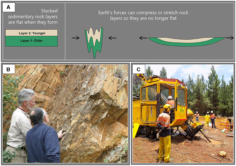
- Figure 1 - (A) Rock layers that were once flat can be affected by forces acting on the Earth’s surface and become tilted or even upright over time.
- (B) An example of tilted but weathered rock layers. (C) The unweathered rock layers from the Barberton Greenstone Belt which we want to study are tilted but hidden beneath the soil.
Very old sedimentary rocks only exist in a few locations, but they can teach us a lot. From sedimentary rocks, we can learn about ancient flowing rivers, tides, storms, temperatures, the composition of the atmosphere, and even the wind speed [1]. The oldest sedimentary rocks are 3.2 billion years old and lie in the Barberton Makhonjwa Mountains of South Africa and Eswatini (Barberton is a small town at the foot of the mountains). Because many of the rocks there are green, geologists call this region the Barberton Greenstone Belt [2].
Learning About “Empty” Earth
We know that Earth was a very different planet back when ancient sedimentary rocks were forming. It would have been unrecognizable to us today: Earth rotated almost twice as fast, so days had only 13 h—lots of sunrises and sunsets! Also, the Moon was much closer, tides were probably higher and may have reached much farther inland, and Earth was covered with many active volcanoes. If animals had existed (which they did not), the sun would have burned their skin within a few minutes. There were no plants yet, and the air had no oxygen [1].
We wanted to know more about the conditions on this “empty” planet that led to the appearance of life. Was Earth back then a deadly place? Or was it just gray and foggy? Answers to such questions come from carefully comparing the ancient rocks with what we see in the modern world. For example, a fossilized raindrop imprint on former mud would perhaps be a hint about ancient rainy weather. Fossilized rock with a rippled surface would hint at the presence of flowing water. Cracks in the rock would indicate that wet mud had dried out, and so on (Figure 2). The minerals in the rock also indicate what kinds of salts the early oceans had, whether there was oxygen in the air, and which type of soil formed.
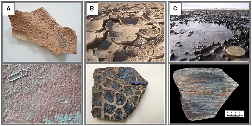
- Figure 2 - “Reading” history in sedimentary rocks.
- Images in the upper row are from today’s sediments; images below are from very old rocks. (A) Raindrop imprints. Rock in the lower row is about 290 million years old. (B) Cracks which grew when mud dried out. Rock in the lower row is about 3,220 million years old. (C) Microbial mats made from dense growth of bacteria; coin for scale. Rock in the lower row is about 3,221 million years old.
But many of these comparisons can be done only on rocks that are still protected from rain, heat, and cold. They must be unweathered and as close to their original composition as possible.
Where to Drill?
We knew we needed to drill into the Earth to get to the rock layers we were interested in, because those rocks are now covered by forest and grassland. First, we had to figure out the best place to drill [3]. We met with other interested scientists to look at the rocks in the Barberton Greenstone Belt, discussed advantages and disadvantages of each site, and then voted where to drill. We decided to drill 8 boreholes, which would allow us to sample rock types that made up ancient rivers, sandy coastlines, the shallow ocean, volcanic rocks, ancient soil, and a delta where the river met the sea.
We then had to ask for permission to drill on other people’s land. Because our drill sites occur in a conservation area, and because past drilling near Barberton was often done to find gold, we had to convince the Barberton community that we were interested in understanding the rocks, not in finding gold [4]. After many presentations, people gradually realized that our results would not lead to the opening of new mines within their beautiful region.
At the same time that we were making these preparations, we were also getting the money together to drill and making sure that the places we had chosen were really the best ones.
Drilling
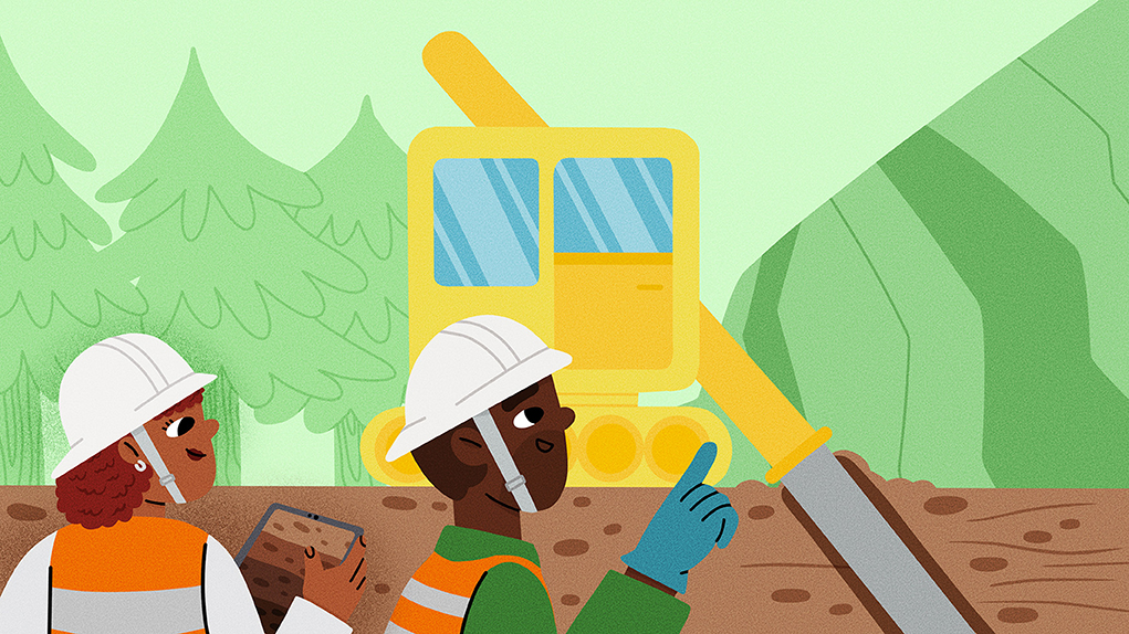
In Barberton, we organized places to live for a year, so that we could work every day (Figures 3A–C). As we mentioned, sedimentary rock layers in these mountains do not lie flat anymore but are vertical, and sometimes even flipped over. Luckily, the drillers knew how to drill sideways, which was good because some of the rock layers were standing on end and we wanted to access as many rock layers as possible. Our boreholes were each between 280–500 m long. Each borehole took about 6–10 weeks to drill.
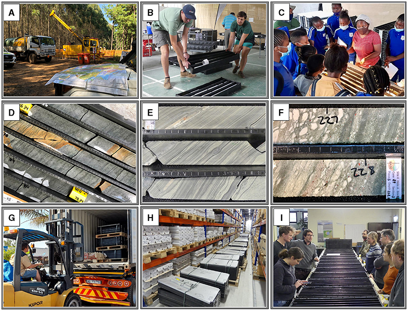
- Figure 3 - The story of a drill core.
- (A) Drill site in the mountains. (B) Moving the core trays. (C) Phumi explaining the rock layers in the core to school children. (D) The black lines in the sandstones of this drill core were once microbial mats. (E) Thin layers of shale represent the tides near a former coastline. (F) “White gravel” consists of soft volcanic rock. (G) Loading more than 500 boxes with rock cores to be moved to the laboratories. (H) Rock cores in storage (a “core library”). (I) Our team, discussing who will do which analyses.
Sometimes, the cores the drillers pulled out of the ground were cracked or weathered, making them impossible to study, but often they were just what we had hoped for (Figures 3D–F). Once we had the cores, we had to cut them in half neatly, right down the middle, so that we could see the layers more clearly. Then we had to label, photograph, describe, and store them. After 9 months, we had filled more than 1,000 black plastic boxes with neatly described rock. The 500 boxes with the right halves of the cores stayed in South Africa, and the 500 boxes with the left halves were loaded in two shipping containers and shipped to Berlin, Germany, to be studied there (Figures 3G–I).
What Have We Learned So Far?
So far, we have learned that we indeed drilled through sediments that had been deposited in various ancient regions: at the foot of mountains, in rivers, in deltas, in tidal flats, along shorelines, even beneath deep ocean water. We can tell that there were tides from the sediment layering patterns [5] (Figure 3E). We may even be able to tell when the moon was full vs. when it was not! We can see that there were lots of volcanic eruptions, and much volcanic ash rained down and became mixed with the sand grains (Figure 3F); sometimes, the sediment had been outright soupy! Between the water-filled delta channels, there were regions that were only flooded once or twice a day but remained dry otherwise; bacteria grew especially well there and made thick layers that even contained air bubbles. Some bacteria may have grown near hot springs with boiling water.
What is Next?
As our research continues, there will be about 50 people from all over the world working with the cores, most of them young scientists (Figure 3I). They will try to find answers to a number of questions, such as: In what conditions did the earliest life forms grow on Earth’s surface, 3.2 billion years ago? How did bacteria protect themselves from the sun’s harsh rays? What did the bacteria “eat” and what kinds of waste products did they produce? Was the occurrence of bacteria exceptional and rare, or was it commonplace?
These questions will be answered by carefully analyzing the drilled cores in laboratories around the world. The information learned from these cores will be made available in presentations at universities and conferences. Importantly, the knowledge will also be shared with the people of South Africa and Barberton who live closest to this very special part of our planet.
Glossary
Sediment: ↑ Natural material that is broken down by weathering and moved by wind, water, ice or gravity. Other sediment (like salt) crystallizes and settles from water; coal may form from plants. Sand and mud are common sediments.
Sedimentary Rock: ↑ A sediment in which the grains or minerals are compressed and connected by other minerals to each other, forming a solid rock. Common sedimentary rocks are sandstone or limestone.
Unweathered: ↑ A rock not affected by rain, air, animals, plant roots, or bacteria at the surface. Most rocks near the surface are weathered. To get unweathered rock, one often has to drill a borehole.
Borehole: ↑ A narrow round shaft bored in the ground, often vertically but sometimes inclined or even horizontally. This may be done for finding water, petroleum, or natural gas, or to investigate the rock.
Core: ↑ The long string of rock that has been drilled through. The core is then investigated.
Conflict of Interest
The authors declare that the research was conducted in the absence of any commercial or financial relationships that could be construed as a potential conflict of interest.
Acknowledgments
Written informed consent was obtained from the individual(s) for the publication of any identifiable images or data included in this article.
References
[1] ↑ Heubeck, C., and Arndt, N. 2015. “Archean environmental conditions”, in Encyclopedia of Astrobiology, 2nd eds. M. Gargaud, R. Amils, J. Cernicharo Quintanulla, H. J. Cleaves, W. M. Irvine, D. Pinti, et al. (Heidelberg: Springer-Verlag) doi: 10.1007/978-3-662-44185-5_97
[2] ↑ Byerly, G. R., Lowe, D. R., Heubeck, C. 2019. “Geologic evolution of the Barberton Greenstone Belt – a unique record of crustal development, surface processes, and early life 3.55 to 3.20 Ga”, in Earth’s Oldest Rocks. 2nd Edition eds. M. J. Van Kranendonk, V. C. Bennett, and J. E., Hoffmann (Amsterdam: Elsevier). p. 569–613. doi: 10.1016/B978-0-444-63901-1.00024-1
[3] ↑ Heubeck, C. 2019. “The Moodies Group - A high-resolution archive of Archaean surface and basin forming processes”, in The Archaean Geology of the Kaapvaal Craton, Southern Africa, eds. A. Kröner, A. Hofmann (Heidelberg: Springer-Verlag). p. 203–241. doi: 10.1007/978-3-319-78652-0_6
[4] ↑ Mashele, P., Christianson, A., Ndazamo, V., Beukes, N., Heubeck, C., Ferrar, T. 2023. “How to obtain community buy-in during research drilling: ICDP BASE Project, Moodies Group, Barberton Greenstone Belt”, in Geological Society of South Africa Geocongress, Stellenbosch. Conference abstract.
[5] ↑ Heubeck, C., Bläsing, S., Drabon, N., Eulenfeld, T., Grund, M., Homann, M., et al. 2022. Reassessing evidence of Moon–Earth dynamics from tidal bundles at 3.2 Ga (Moodies Group, Barberton Greenstone Belt, South Africa). Sedimentology 69:2029–2052. doi: 10.1111/sed.12988