Abstract
Why do scientists drill into the Earth? Drilling is a valuable tool to unravel secrets of the planet’s history because lots of information is safely stored deep below our feet within the Earth. By taking samples from deep in the Earth and performing laboratory tests on them, scientists find rock materials, water, bacteria, and fossils that can help to unravel mysteries of life and the environment over millions of years. Drilling is also important for finding sustainable new resources, such as geothermal heat, which can be used to produce energy for our homes. Drilling can also help us understand and protect our planet. Another important reason for drilling is to install specific instruments deep in the Earth, to monitor Earth’s movements. These instruments help us to better understand natural disasters like earthquakes or volcanic eruptions and can enhance the safety of billions of people worldwide.
Digging Into the Past to Unravel Our Future
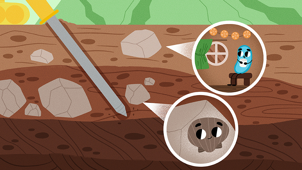
This article takes you on a journey deep below the Earth’s surface, where hidden secrets from our past and valuable treasures for our future are awaiting to be discovered. Scientists use drilling to unlock Earth’s treasures that contain important clues to unanswered questions. When we drill into the Earth’s surface, we create holes called boreholes. A borehole is like a narrow shaft drilled several km deep into the Earth. The deepest borehole ever drilled is located on the Russian Kola Peninsula [1, 2]. The reason for drilling was the search for minerals and to collect information on the structure of the Earth’s crust. The borehole reached more than 12 km in depth, approximately the length of 120 football fields. But did you know that the Earth has a radius of about 6,371 km? The Earth is separated into the crust, the mantle, the outer core and the inner core (Figure 1). The thin crust is just 30 km thick on the continents. Drilling into deeper parts of the Earth is not yet possible. Rising pressures and temperatures deep in the Earth make drilling challenging. The drilling machines and tools can break easily or melt like a snowman in the summer sun when the temperature get too high (>250°C).
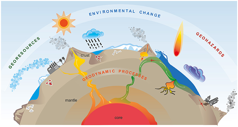
- Figure 1 - Topics that motivate scientists to drill into the Earth.
- The interior of the Earth is roughly divided into the extremely hot core, the semi-solid mantle, and the thin crust on which we live. Geodynamic processes transport heat from the core to the Earth’s surface and are responsible for plate tectonics, earthquakes, and volcanic activities. We use georesources like heat, oil, gas, and coal to produce energy. Geohazards include earthquakes and volcanic activities but also events like meteorite impacts. Earth’s environment includes everything around us, like the air, weather, water, ice, and living organisms (Figure modified from [3]).
Boreholes are drilled all over the world, on land and even into the seafloor. They are mostly used to find valuable goods like groundwater, oil, or metal resources. However, the goal of a few drillings is to explore our planet and help to unravel secrets of the Earth’s history and the history of life [2]. Drilling helps scientists to get a better picture of the interior of the Earth. Lots of information can be obtained from rock material that is removed from the Earth by drilling (Figure 2A). The cylindrical shaped rock samples are called drill cores (Figures 2B, C). These can be analyzed, for instance, in the laboratory. It is also possible to take measurements inside the boreholes [1]. All information is important for our modern society.
![Figure 2 - (A) The KTB-Borehole in southern Germany, drilled between 1987–1994, is one of the deepest scientifically used boreholes worldwide—at a depth of about 9,101 m [1, 4].](https://www.frontiersin.org/files/Articles/1253426/frym-11-1253426-HTML-r1/image_m/figure-2.jpg)
- Figure 2 - (A) The KTB-Borehole in southern Germany, drilled between 1987–1994, is one of the deepest scientifically used boreholes worldwide—at a depth of about 9,101 m [1, 4].
- The drilling tower (officially called “derrick”) marks the location of the borehole, which is directly below. (B) Samples from such boreholes provide key information about Earth. Such samples are called drill cores, and they can be taken from boreholes during the drilling process. (C) The core drilling bit cuts a cylindrical shaped column of rock with its rotating cones, which is then lifted to the surface with the drilling rig [5] (Figure credits: (A) Gunnar Pruß, GFZ Potsdam; (B) ICDP supported GRIND project).
Climate and Environment
The history of our environment, with its climate, plants, animals, and even tiny microbes, is recorded in sediment layers found in lakes and seas [2]. By drilling into these layers, the recovered drill cores can be read like a book. Each tiny layer of sand and clay contains traces of plants or fossils of tiny organisms of the past. From these, scientists can reconstruct what the temperatures and rainfalls were like hundreds to millions of years ago [2, 3]. The sediment layers add up to an animated picture of how landscapes, life, and climate changed over time. By gathering information from various places all over the world, scientists can understand what causes climate and environmental changes. They can distinguish which changes were caused by natural impacts and which changes are related to human activities.
Currently, researchers are very interested in understanding the reasons for rapid climate changes in the past. For example, 66 million years ago, a giant meteorite hit the Earth and caused the extinction of most animals, including the dinosaurs. This meteorite impact led to tsunamis, wildfires, dust in the atmosphere, and acid rainfalls that made our planet uninhabitable for most lifeforms. But how did the Earth recover and rebuild a stable, life-friendly climate? What can we learn from such past rapid climate changes and what do they tell us about our future? The answers are hidden below our feet, and scientists are working hard to uncover them.
Georesources
A healthy atmosphere is extremely important for life on Earth, next to food and drinkable water. But modern life requires further resources, such as energy sources for heating and power generation. Georesources are natural resources that come from the Earth. Drilling is a useful tool to search for these valuable resources. Unfortunately, conventional energy resources such as coal, oil, and gas contribute to air pollution and lead to climate change in the form of global warming. To preserve Earth’s climate, we must discover more environmentally friendly ways to produce energy [3]. We can use renewable energy coming from the wind and the sun… but what can we rely on when it is dark and windless? The answer lies right below our feet.
The temperature within Earth’s crust increases on average about 3°C every 100 m. In places where the crust is very thin, for example in volcanic areas, we can find geothermal fields where the heat from the Earth’s mantle (typically more than 1,400°C) can rise to shallow depths in the crust. The heat stored in crustal rocks warms up deep groundwaters. By drilling into these rocks, we can access this heat reservoir and built power plants on top of the site, to use the heat as a source of clean, sustainable energy known as geothermal energy (Figure 3).
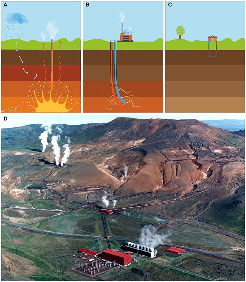
- Figure 3 - Currently, three categories of geothermal energy sources are investigated to help protect Earth’s environment: (A) ultra-high temperature systems that exist in volcanic areas; (B) deep geothermal wells; and (C) shallow geothermal wells that are most often used to heat individual houses.
- The heat naturally stored underground is transported to the surface through drilled boreholes. (D) The geothermal power plant in Iceland, close to the Krafla volcano, generates electricity for local communities (Figure credit: (A–C), [6]).
Shallow geothermal wells (Figure 3C) are becoming popular ways to heat people’s houses. This system uses water that circulates through pipes underground and carries the heat to the surface, where it is used to warm up houses in winter. Deep geothermal wells (Figure 3B) can produce energy for nearby areas. Here, water is also used. It is pumped deep underground (a few kilometers) where it is even hotter. The water can get so hot that it turns into steam like it does when you boil it in a kettle at home. The high pressure underground pushes the steam back to the surface through a well, where it is used to run turbines that produce electricity pretty much like windmills do. However, to produce enough energy for big cities, we must drill even deeper and investigate ultra-high temperature systems (Figure 3A). These systems can be found in volcanic areas, for example, but are not well investigated yet—and investigating them is challenging. Super deep wells (several kilometers) are needed, and they work similar to deep geothermal wells but at much higher pressures and temperatures. These super deep wells can create much more energy and are thus much more effective for producing electricity.
Currently, scientists are making exciting plans to take things to the next level, by drilling into the Krafla Volcano in Iceland (Figure 3B). The aim is to reach the 900°C hot magma, to make use of this giant energy resource [3]. Will such a borehole be stable and safe? Hopefully this drilling project will provide the answer.
Geodynamics
Drilling is also a useful tool to better understand Earth’s geodynamics. Geodynamics is all about understanding forces and processes that shape Earth. The crust, for instance, is a big puzzle of large and small plates, which can be separated into continental (land) and oceanic (underwater) plates. We know that the movements of these plates create mountains and valleys over time, at the same speed at which our fingernails grow. This process is called plate tectonics. But there are still mysteries to be solved [3]. Why and when did plate tectonics start? How do movements of plates influence Earth’s atmosphere and climate? How did ice ages and warm periods affect the evolution of life on Earth? From drill cores, we already learned that life forms must have enriched the early atmosphere with oxygen. Marine shells stored many tons of carbon dioxide, a greenhouse gas. These processes likely made life on Earth possible. To better understand Earth’s geodynamic cycles, scientists must drill deep into the crust to recover the rocky archives, which provide evidence and answers to these riddles.
Geohazards and Risks
In addition to all that you have already learned, boreholes can literally help save lives! Scientists can place special instruments inside boreholes to measure, for instance, Earth’s underground movements. The instruments record very small to really large vibrations and shape changes of rocks and faults (big cracks in the Earth, like the San Andreas Fault in California, USA). Such instruments can also be placed on the Earth’s surface, but many human-made noises (such as vibrations caused by big trucks) or even strong winds distort surface measurements. By contrast, instruments placed in boreholes are far away from such disturbing signals and much closer to Earth’s “heartbeat”. This helps instruments to record only the really interesting signals, for instance those caused by earthquakes or magma movements beneath volcanos [3]. Such signals can be used as a warning system for people living nearby. If the signals change very drastically, for instance if there are an unusually large number of small earthquakes, scientists can send out an alert. This kind of system has already helped to protect people from geohazards and related risks caused by large earthquakes or volcanic activities. Furthermore, drilling into faults, for instance, can provide valuable information on how and why earthquakes occur [2, 3].
The Impactful Role Of Scientific Drilling
As you can see, the world of scientific drilling is fascinating because it opens up a whole new world beneath our feet. Drilling into the Earth is an important tool for scientists, as it helps to unravel mysteries of Earth’s past and to find resources important for society—both today and in the future. Scientific drilling is a key to understand how our planet has changed over time and how it will continue to change. The newly gained information and access to more environmentally friendly resources can help us to better protect the environment. Furthermore, understanding geodynamic processes helps us to decrease the impact of natural disasters, including earthquakes and volcanic eruptions. Overall, research with boreholes is like using telescopes to look into the unknown under our feet! There is still so much more to explore, so let us continue to be curious about our planet and the environment around us.
Glossary
Borehole: ↑ A deep hole drilled into the ground to extract water, oil, gas, or minerals and to explore Earth’s secrets and history.
Georesources: ↑ Earth’s valuable materials, like minerals, oil, gas, coal, and heat, essential for the modern society.
Geothermal Field: ↑ An area where the Earth’s heat comes to the surface, forming hot springs and geysers, with the potential to use this natural heat for clean energy production.
Sustainable Energy: ↑ Energy from sources that are naturally replenishing and do not harm the environment by releasing greenhouse gases, such as geothermal heat, solar, and wind power.
Geothermal Energy: ↑ The natural heat from the Earth’s interior rising up to the surface that can be used for the production of clean energy.
Geodynamics: ↑ A research field that explores dynamic processes that shaped the Earth over time, including tectonic plate movements that cause earthquakes and form mountains.
Plate Tectonics: ↑ The Earth’s crust is broken into large and small pieces forming a puzzle. These pieces move because of geodynamic forces and cause earthquakes, volcanoes, mountains, and valleys.
Geohazards: ↑ Dangerous natural events like earthquakes or volcanic eruptions, which can cause tsunamis, landslides, fires, and collapsed buildings.
Conflict of Interest
The authors declare that the research was conducted in the absence of any commercial or financial relationships that could be construed as a potential conflict of interest.
References
[1] ↑ Harms, U. 2014. Bohrungen: Ein Instrument der Wissenschaft. Syst. Erde. 4:6–13. doi: 10.2312/GFZ.syserde.04.01.1
[2] ↑ Harms, U., and Wiersberg, T. 2018. “The thrill to drill – After more than two decades of International Continental Scientific Drilling: a prospect for the future”, in International Continental Scientific Drilling Program GFZ German Research Centre for Geosciences (Potsdam, Germany). Available online at: https://www.icdp-online.org/fileadmin/icdp/media/doc/The_Thrill_To_Drill_2018_HR_small.pdf (accessed July 5, 2023).
[3] ↑ Anselmetti, F., Ashwal, L., Ariztegui, D., Bohnhoff, M., Bomberg, M., Clayes, P. et al. 2020. ICDP Science Plan: 2020-2030. Potsdam: International Continental Scientific Drilling Program. doi: 10.2312/icdp.2020.001
[4] ↑ Harms, U., and Kück, J., 2016. Superdeep Tests and Experiments at 9.1 km and 4 km. J. Large-Scale Res. Facil. 2:A75. doi: 10.17815/jlsrf-2-132
[5] ↑ Harms, U., and Wöhrl, T. 2006. “The thrill to drill – After a decade of International Continental Scientific Drilling: a prospect for the future”, in International Continental Scientific Drilling Program GeoFoschungsZentrum Potsdam. (Potsdam, Germany). Available online at: https://gfzpublic.gfz-potsdam.de/rest/items/item_238891_1/component/file_238890/content (accessed July 5, 2023).
[6] ↑ ICDP Task Force on Geothermal Strategy 2022. Support for geothermal drilling projects, Potsdam: International Continental Scientific Drilling Program. Potsdam, Germany. Available online at: https://www.icdp-online.org/fileadmin/New_ICDP_website/Outreach/doc/ICDP_GeothermalSupportFinal_Digital.pdf (accessed July 5, 2023).