
Abstract
As Earth’s climate continues to warm, extreme weather events like severe storms and floods are becoming more common, endangering many lives. To help keep people safe, we have developed a computer model called DTE Hydrology—kind of like a scientific video game—that can warn people if flooding is likely in their area. This model is known as a “digital twin” of the Earth because it is almost like having a computer-based copy of the planet! Measurements of rainfall and soil moisture can be collected both on Earth and from satellites, and the model can use these data to predict the likelihood of flooding in a given area. We can also use DTE Hydrology to “experiment” on Earth’s digital twin, to learn more about what causes flooding. In the future, we hope to use this system to save even more lives by predicting landslides and monitoring wildfires, too.
Imagine that you are on summer break, but it has been raining for days. How boring! You have slept in each morning, played all your favorite online games, watched movies, and texted with your friends…but now you are out of ideas. You daydream about enjoying the summer sun with your friends, maybe swimming or fishing in the nearby river. Hopefully the rain will stop soon! You walk to the window to check the weather, and are shocked to see that the houses just down the hill are up to their windows in muddy water…and the rising water is quickly approaching your house! Trees, trash, and even a few cars are floating by; you see rescue boats at a nearby home, helping your neighbors who had climbed onto their roof to escape the rising water. A flash flood!
Humans Are Changing Earth’s Weather…For the Worse
While this scene might sound like the start of a suspenseful disaster movie, the daily news tells us that such scenarios are also happening in real life. In the summer of 2021, intense storms led to flash flooding in Europe. Rivers and streams rose quickly, causing the deaths of at least 243 people, most of them in Germany. On an even larger scale, unusually heavy monsoon rains in the summer of 2022 caused extreme flooding in Pakistan, causing the deaths of 1,739 people—including 647 children—and injuring almost 13,000 others. In addition to causing deaths and injuries, floods can kill crops, reducing our food supply; and they can cause major damage to homes, roads, hospitals, and power grids, grinding normal life to a halt. Pakistan’s floods caused an estimated $30 billion in damage, for example.
Human activities that release carbon dioxide and other greenhouse gases into the atmosphere are warming the Earth and changing our climate. As temperatures continue to rise, the number and severity of floods is predicted to increase, but floods are not the only problem—scientists predict increases in both the frequency and intensity of other dangerous weather-related events as well, like landslides, droughts, and wildfires (for more information about how climate change is increasing extreme weather events, see this FYM article or this one).
Water, Water Everywhere
While it is clearly important to do all we can to reduce greenhouse gas emissions and combat climate change, in the short term we must also figure out ways to protect people from extreme weather events like floods. One of the reasons floods can cause many deaths and injuries is because they are difficult to predict. As the name implies, flash floods happen quickly—people in their paths often have little warning, so they do not have enough time to evacuate. If there was an accurate system that could predict which areas were likely to flood, people in those areas could be warned in advance, and they could move to safety in time. Such a system could potentially save many human lives.
Detailed knowledge of the water cycle is necessary for understanding why flooding happens and figuring out how to predict it. Three main components of the water cycle are particularly important when it comes to flooding and flood prediction: precipitation, soil moisture, and runoff (Figure 1). Precipitation is water released from clouds in the form of rain, hail, snow, or sleet. As you probably know, the more precipitation there is, the higher the risk of flooding. But soil moisture, which is a measure of the water content of the soil, also plays a role. The more water there is in the soil, the less “room” there is for additional rainwater. If the soil is saturated and cannot absorb any more water, any precipitation that falls will become runoff—flowing along the ground to fill rivers and streams, which can then rise and cause floods.
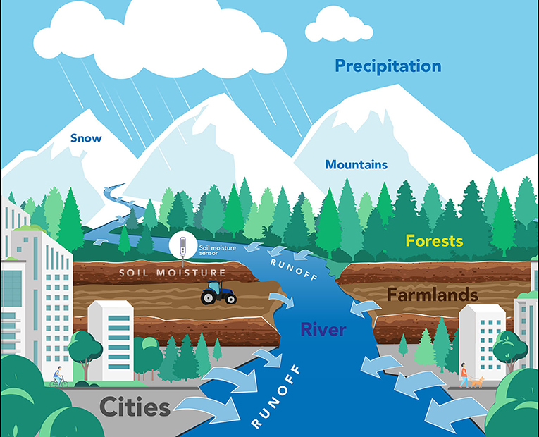
- Figure 1 - While accurate prediction of flooding requires knowledge of the entire water cycle, several components of the cycle are particularly important.
- Precipitation (rain, snow, sleet) falls from the clouds and flows off the land into rivers and streams. This runoff increases the water level in rivers and streams. The amount of runoff is dependent on soil moisture. Soil that is already saturated with water can hold less precipitation, resulting in more runoff and greater flood risk. If runoff causes rivers and streams to overflow their banks, flooding can occur.
While this explanation may sound simple, there are many more processes involved in the water cycle, and they all interact with each other in ways that are difficult to predict. Additionally, humans influence the water cycle and affect the likelihood of floods—not just through climate change but also by cutting down forests, building cities and roads, and certain types of farming. All these natural and manmade complexities make it extremely difficult to predict exactly when and where floods will happen.
Earth’s Digital Twin
Obviously, scientists cannot do experiments with Earth’s weather to learn how to predict floods. So, how can we learn what would happen if, for example, 15 cm of rain fell on an area with moderately saturated soil? Would local rivers and streams flood, and how much? To study situations that are difficult to experiment on directly, scientists can develop a realistic simulation, kind of like a scientific video game, that accurately recreates conditions on Earth. This “game” is called a computer model. Using this “game,” scientists can ask “what if” questions like the one above—they can tweak the amount of rainfall, soil moisture, and other conditions, to see how much rivers or streams would rise in a certain area (Figure 2). This is almost like having a computer-based copy of the Earth to experiment on, which is why these models are called digital twins of the Earth (DTEs). Our group has been developing a DTE focused on Earth’s water-related processes. We call it DTE Hydrology, and we hope that one day it will help predict whether a flood is likely to happen in your area.
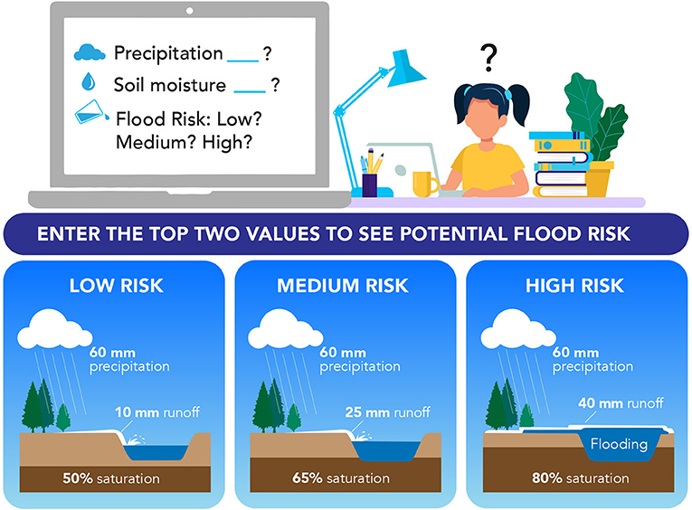
- Figure 2 - DTE Hydrology is like a scientific “video game” that can help scientists to predict the risk of flooding.
- The computer model allows scientists to “experiment” by entering different values for the amounts of precipitation and soil moisture, to see whether those conditions increase the flood risk in a certain area. In the example, the amount of precipitation is kept constant, but you can see that increased soil moisture increases flood risk. Governments could use a computer model like this to protect people, by calling for evacuations when flooding is likely, for example.
A “Flood” of Data
To predict flooding in real life, DTE Hydrology needs a huge amount of data about the actual conditions on Earth. As we mentioned earlier, the two main processes that contribute to runoff—and the flooding that occurs when there is too much of it—are precipitation and soil moisture. These two factors can be measured directly (right where they are happening) or remotely (from somewhere else) [1, 2]. Direct measurement of precipitation can be done using rain gauges, which capture and collect rainwater so that it can be measured (in inches or centimeters) after each rain event. Soil moisture can be directly determined by taking soil samples and measuring how much water they contain (Figure 3A). While direct measurements are extremely accurate, not all areas of Earth can be measured, and conditions constantly change with the weather and seasons—so direct measurement gives us limited information. Remote measurements often involve satellite images of Earth. Satellites can be equipped with imaging systems that can take digital images of a very large area or even of the entire Earth—which is a big advantage over direct measurements. Scientists can interpret these images to learn about many conditions on Earth, including precipitation and soil moisture.
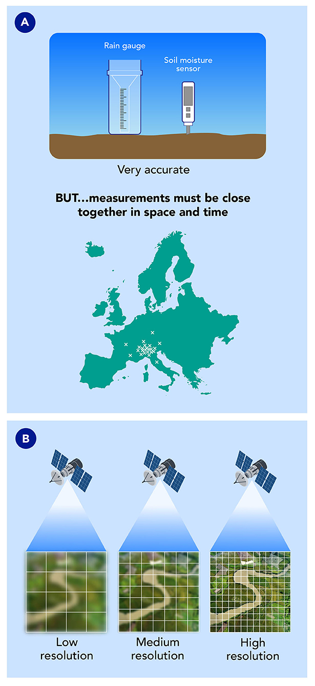
- Figure 3 - (A) To collect data on precipitation and soil moisture for a computer model, rain gauges and soil moisture sensors can be placed in various locations on Earth.
- While these devices are very accurate, it is difficult to get enough direct measurements to create an accurate computer model. (B) Satellites that take images of Earth from space can provide a lot of data. To be most useful, these remote images must be high resolution, which means they must be able to “zoom in” on small areas and take images often, to capture rapidly changing conditions.
The usefulness of satellite images for predicting floods or other weather-related events depends on their resolution, or level of detail. Precipitation and soil moisture—and therefore the potential for flooding—can vary a lot over small distances, so satellite images will obviously be more useful for flood prediction if they can “zoom in” on small areas (Figure 3B). Which would make you feel safer: a low-resolution flood-prediction system that could only predict that a flood is likely to happen somewhere within a 100-km radius of your home, or a high-resolution system that could tell you flooding was likely within 1 km of your home? Another aspect of resolution has to do with how often a satellite takes an image of the same location. The higher this type of resolution, the more closely satellite data match the actual situation on Earth, in real time. Flooding events can develop quickly and occur over very short time periods. Again, which would make you feel safer—a flood-prediction system that collects data once every 3 days, or one that collects data once an hour? Some modern satellites can provide extremely high-resolution data, which are excellent for flood prediction [3].
The Future of Flood Prediction
We are still developing DTE Hydrology, using a combination of direct and remote measurements. This is a lot of data to deal with, but there is more! While this article focuses on precipitation and soil moisture, we also collect measurements on evaporation, snow depth, and the volume of water moving through rivers. You can check out DTE Hydrology yourself here. So far, our computer model covers an area of 1,580,000 km2 in the Mediterranean basin, but we are working to expand it to eventually include all of Europe.
When fully developed, DTE Hydrology will be able to do much more than predict floods…it may be able to accurately predict landslides and monitor wildfires. As climate change continues and we face more—and more dangerous—extreme weather events, early-detection systems that can predict floods and other natural disasters can help to save the lives of adults and children across the world. Running “what if” scenarios using DTE Hydrology can also help scientists to better understand the complexities of Earth’s water cycle, allowing European countries to balance their water use among various needs, including communities, industries, and farms. Water is our planet’s most precious resource—living things cannot exist without it. With DTE Hydrology, we aim to protect life on Earth: both by warning humans of dangerous, water-related events and by safeguarding our planet’s water resources for future generations.
Glossary
Flash Flood: ↑ Rapid flooding in a local area that usually happens a short time after heavy rainfall.
Water Cycle: ↑ The complex processes through which Earth’s water is “recycled” as it moves through different states (liquid, solid, and gas). Processes of the water cycle include precipitation, evaporation, and condensation.
Precipitation: ↑ Water falling from clouds in the form of rain, snow, sleet, or hail.
Soil Moisture: ↑ The amount of water contained in the soil. The higher the soil moisture, the more saturated the soil and the less precipitation it can absorb.
Runoff: ↑ Water that does not soak into the soil and instead flows off of the land and into rivers and streams, increasing their levels.
Computer Model: ↑ Any computer-based representation of a complex situation or system.
Digital Twin: ↑ A computer-based representation of a real-life system or process, built to match the real-life situation closely enough to allow users to experiment and ask “what if” questions.
Resolution: ↑ The level of detail of a measurement, both in terms of how “zoomed in” measurements are and how close together they are taken over time.
Conflict of Interest
The author declares that the research was conducted in the absence of any commercial or financial relationships that could be construed as a potential conflict of interest.
Acknowledgments
Co-written by Susan Debad Ph.D., graduate of the University of Massachusetts Graduate School of Biomedical Sciences (USA) and scientific writer/editor at SJD Consulting, LLC. Silvia Barbetta, Stefania Camici, Luca Ciabatta, Jacopo Dari, Paolo Filippucci, Christian Massari, Sara Modanesi, Angelica Tarpanelli, Bianca Bonaccorsi, Hamidreza Mosaffa, Wolfgang Wagner, Mariette Vreugdenhil, Raphael Quast, Lorenzo Alfieri, Simone Gabellani, Francesco Avanzi, Dominik Rains, Diego G. Miralles, Simone Mantovani, Christian Briese, Alessio Domeneghetti, Alexander Jacob, Mariapina Castelli, Gustau Camps-Valls, Espen Volden, and Diego Fernandez were coauthors on the original manuscript.
Original Source Article
↑Brocca, L., Barbetta, S., Camici, S., Ciabatta, L., Dari, J., Filippucci, P., et al. 2024. A digital twin of the terrestrial water cycle: a glimpse into the future through high-resolution Earth observations. Front. Sci. 1:1190191. doi: 10.3389/fsci.2023.1190191
References
[1] ↑ Filippucci, P., Brocca, L., Quast, R., Ciabatta, L., Saltalippi, C., Wagner, W., et al. 2022. High resolution (1 km) satellite rainfall estimation from SM2RAIN applied to Sentinel-1: Po River Basin as case study. Hydrol. Earth Syst. Sci. 26:2481–97. doi: 10.5194/hess-26-2481-2022
[2] ↑ Peng, J., Albergel, C., Balenzano, A., Brocca, L., Cartus, O., Cosh, M., et al. 2021. A roadmap for high-resolution satellite soil moisture applications – confronting product characteristics with user requirements. Remote Sens. Environ. 252:112162. doi: 10.1016/j.rse.2020.112162
[3] ↑ Alfieri, L., Avanzi, F., Delogu, F., Gabellani, S., Bruno, G., Campo, L., et al. 2022. High resolution satellite products improve hydrological modeling in northern Italy. Hydrol. Earth Syst. Sci. 26:3921–39. doi: 10.5194/hess-26-3921-2022