Abstract
Trees make our cities and urban areas more livable. Trees provide many benefits, known as ecosystem services, to residents. Cities often make management plans and care for their trees to increase the benefits provided by their urban forests. These plans often include goals to increase tree cover. This study assessed tree cover in 300 Florida (U.S.A.) cities. Each city’s urban tree canopy coverage (a percentage of how much of a city is covered by the leafy tops of trees) was analyzed. The goal was to assess the effects of hurricanes, past land cover, and local laws on total tree cover. The study found that hurricanes can decrease tree canopy coverage. It also found that the type of land cover present before a city was built can predict present canopy coverage. Results also found that some local laws can protect or enhance urban tree canopy, even in the face of city development and natural disasters.
What is an Urban Forest?
The urban forest is a term used to describe a collection of plants growing in and around human communities [1]. Urban forests provide many benefits, known as ecosystem services, to their residents. These services include reducing the energy needed to cool buildings, improving human health, and providing food. Urban forests can also reduce air pollution, stormwater runoff, and the buildup of heat in urban environments [2]. Woody plants such as trees and shrubs are especially important in urban communities. Research and resources should be used to save and enhance these plants.
The amount of urban forest in a town or city can be estimated by measuring its urban tree canopy (UTC). UTC is often measured as the percentage of a city’s ground area covered above by the tops of trees. This percentage can be measured in two ways. Researchers can count trees on the ground and estimate their crown size, or overhead photos of an area can be used to find the amount of tree coverage in each area.
The amount of canopy coverage a community has can be influenced by environmental and human factors. Environmental factors include natural disasters and climate. Human factors include how the land was used in the past and laws regulating land use (Figure 1). This study used data from several types of maps to study the effects of hurricanes, past land use, and local laws on UTC.
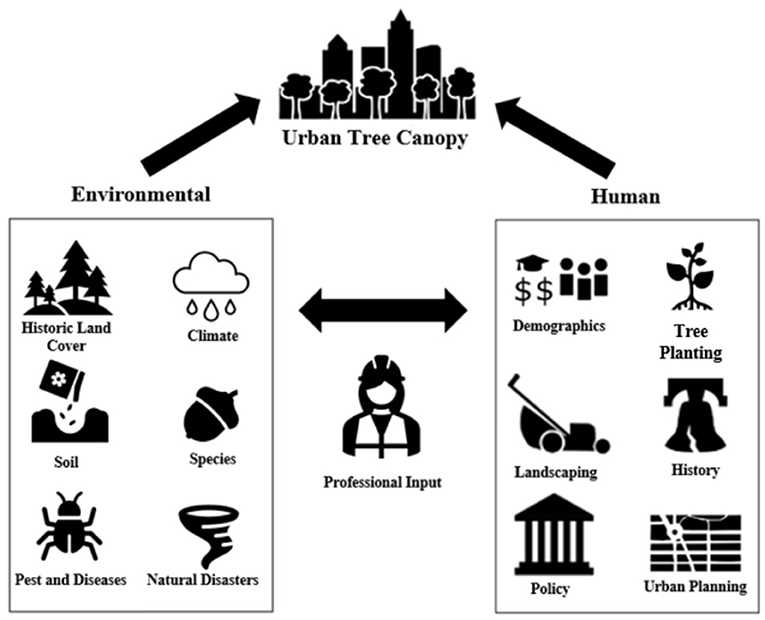
- Figure 1 - Both environmental and human factors can influence UTC.
- Input from professionals in the tree community can influence how a city cares for UTC as well (Image credit: Adapted from Salisbury et al. [3]).
How Did we Estimate Urban Tree Canopy?
For this study, we looked at 300 Florida (U.S.A.) cities and used overhead photos to measure the UTC. We created random points on a map of each city using mapping software. A team of researchers then identified each point on each map as “tree,” “no tree,” or “open water.” We then estimated canopy coverage for each city using at least 2,000 of these points (excluding “open water” points). The total number of points classified as “tree” was divided by the total number of points in the city (and then multiplied the results by 100), to give us a UTC percentage.
Do Hurricanes Influence Florida’s Urban Forest?
As climate change increases, hurricanes are becoming more common and are getting stronger. It is important to understand how hurricanes can affect UTC, so that we can come up with ways to fight upcoming climate challenges. Once canopy coverage for each city was calculated, we added wind data. Our study looked at the most recent hurricanes in Florida that were declared disasters. These were hurricanes Dorian, Michael, and Irma. To determine how each city was impacted by these hurricanes, we used the mapping software to place a city boundary map layer over a map layer with wind data. For analysis, we used the maximum wind speed in a city during any of the three hurricanes. If a city was hit with more than one of the hurricanes, we used the highest wind speed recorded out of all three.
Our study found that cities with stronger hurricane winds had less tree coverage. For cities hit directly by the worst storm (Michael), canopy cover decreased by 7.7%. This is important because this decrease lowers the ecosystem services that an urban forest can provide to a community.
The Effect of Past Land Cover
Land cover describes what is found on the Earth’s surface. Examples are forests, grasslands, and urban areas. Past land cover can help us understand how land changes over time. For example, looking at previous land cover may show that a forest was cut down to make room for a farm.
It is important to understand what kind of land cover was present before an urban area was built, because it can tell us whether there would naturally be any trees in that area if the city had not been built. For example, an area classified as “non-forest” before a city was built, like an extremely dry area, might not have the best conditions for trees to grow. Past land cover can influence a current city’s UTC. For example, an area that was dry and had few trees before a city was built would have a lower current-day tree cover, unless more trees were planted.
We compared the current UTC of our chosen 300 Florida cities to a map of historic land cover, which shows the vegetation types that were present throughout Florida in 1967 (Figure 2). Using this data, we labeled each of the 300 cities as “forest” or “non-forest” historic land cover.
![Figure 2 - The land cover of Florida in 1967 [4].](https://www.frontiersin.org/files/Articles/749805/frym-10-749805-HTML-r1/image_m/figure-2.jpg)
- Figure 2 - The land cover of Florida in 1967 [4].
- Reproduced with permission from the Florida Climate Institute.
From this data, we saw that 72% of the studied cities were built on land that was formerly forested. The type of historic land cover a city had influenced its current tree coverage. For example, cities on land that did not previously support the growth of trees (such as non-forested areas and wetlands) had lower current tree coverage than cities on land that did previously support the growth of trees. This is important because a city can use historic land cover to plan for its canopy goals. For example, a community in an area with non-forested historic land cover may need to plant more trees. That community may also need to provide more care for new trees compared to a community with forested historic land cover. Because each area is different, maintaining and increasing urban tree canopy is a local responsibility.
The Effect of Local Laws
In Florida, many areas have several types of tree-protection ordinances, or laws, that help to care for tree canopies. For example, heritage tree ordinances ban the removal of old trees that are over a certain size. Tree-removal permit ordinances require landowners to obtain permits before trees can be removed.
To find out which ordinances a community had in place, two methods were used. First, a survey was emailed to the cities in the study. The other method was a search of online resources to determine which ordinances were in place within the 300 cities. The ordinances can be seen in Table 1. After the information was collected, we compared the tree ordinances of each city to its estimated UTC.
| Ordinance | Definition | Cities with this ordinance |
| Hazardous tree ordinance | Cities require the removal of dead, diseased, or dangerous trees | 244 (81%) |
| Tree preservation ordinance | Communities require the preservation of trees during development | 260 (87%) |
| Planting requirements—new developments | Communities require tree planting/coverage in new developments | 268 (89%) |
| Planting requirements—new parking lots | Communities require tree planting/coverage in parking lots | 268 (89%) |
| Removal permit ordinance | Homeowners must request permission to cut down trees on their property | 138 (46%) |
| Heritage tree ordinance | Communities identify and protect large or old trees | 211 (70%) |
| Ability to fine | Communities can fine people who break tree laws | 252 (84%) |
| Local licensure | Communities require companies that prune or remove trees to have business licenses | 53 (18%) |
- Table 1 - Ordinances in place in the 300 Florida cities studied (Table credit: Adapted from Koeser et al. [6]).
We found eight tree-related ordinances and, of these, six were adopted by more than half of the 300 cities that we studied. The most common ordinances included planting requirements for new developments and parking lots. The only ordinance that had a positive effect on tree coverage was the heritage tree ordinance, which was present in 70.3% of cities. Cities with heritage tree ordinances have more tree coverage because older, larger trees are protected. Larger trees have crowns that cover more area, so larger trees will contribute more to UTC.
Not all the protective laws were linked to an increased UTC. These results are important because they show that having laws to protect trees does not necessarily mean a city will have more canopy coverage. When communities set goals for their UTCs, they should consider the ordinances that are in place and how they can best use those laws to increase the city’s canopy coverage.
Overall Findings
All three of the factors in this study (hurricanes, past land cover, and local laws) affected UTC across the 300 cities that we studied. By looking at hurricane winds, we found that tree coverage of hurricane-impacted areas is lower than that of areas not hit as hard. This shows that hurricanes influence tree coverage. It is important to consider this when managing the canopy of areas that are more likely to be hit by hurricanes. The past land cover of an area also explains differences in tree coverage from one city to another. Using information about past land cover can help cities create more realistic goals for their urban forests. We also found that heritage tree ordinances were associated with greater canopy cover, but other tree-protection ordinances did not have the same results. Knowing how these three factors influence canopy coverage can help people create plans to increase and save their UTCs. This way, communities can take advantage of the ecosystem services from urban trees and benefit from those services for many years to come.
Funding
Funding for this research was provided by the Florida Forest Service and the University of Florida Center for Land Use Efficiency (CLUE). Matching funds (50%) for the article publishing charges provided by the University of Florida Gulf Coast Research and Education Center.
Glossary
Urban Forest: ↑ A densely wooded area located in a city. Usually referring to trees and shrubs.
Ecosystem Services: ↑ The benefits humans receive from nature.
Urban Tree Canopy (UTC): ↑ The total area of the leafy, green cover from the trees of a community’s urban forest. As a percentage, it describes how much land is covered by trees.
Crown: ↑ The total of a plant’s above-ground parts, including stems, branches, twigs, leaves, and reproductive structures.
Canopy: ↑ The tree cover created by the crowns of trees and other woody plants.
Map Layer: ↑ Data within mapping software that can be added on top of an aerial image to provide additional information, such as the boundaries of a city or a set of data points.
Land Cover: ↑ The physical material at the surface of the earth.
Ordinance: ↑ A law enacted by a city or town.
Conflict of Interest
The authors declare that the research was conducted in the absence of any commercial or financial relationships that could be construed as a potential conflict of interest.
Original Source Article
↑Salisbury, A. B., Koeser, A. K., Hauer R. J., Hilbert, D. R., Abd-Elrahman, A. H., Andreu, M. G., et al. 2022. The legacy of hurricanes, historic land cover, and municipal ordinances on urban tree canopy in Florida (United States). Front. For. Glob. Change. 5:742157. doi: 10.3389/ffgc.2022.742157
References
[1] ↑ Nowak D. J., Stein S. M., Randler P. B., Greenfield E. J., Comas S. J., Carr M. A., et al. 2010. Sustaining America’s Urban Trees and Forests. Newtown Square (PA, USA): USDA (United States Department of Agriculture) Forest Service Northern Research Station. General Technical Report NRS-62. doi: 10.2737/NRS-GTR-62
[2] ↑ Turner-Skoff, J. B., and Cavender, N. 2019. The benefits of trees for livable and sustainable communities. Plants People Planet. 1:323–35. doi: 10.1002/ppp3.39
[3] ↑ Salisbury, A. B., Koeser, A. K., Hauer R. J., Hilbert, D. R., Abd-Elrahman, A. H., Andreu, M. G., et al. 2022. The legacy of hurricanes, historic land cover, and municipal ordinances on urban tree canopy in Florida (United States). Front. For. Glob. Change. 5:742157. doi: 10.3389/ffgc.2022.742157
[4] ↑ Volk, M. I., Hoctor, T. S., Nettles, B. B., Hilsenbeck, R., Putz, F. E., and Oetting, J. 2017. Florida Land Use and Land Cover Change in the Past 100 Years. Florida’s Climate: Changes, Variations, & Impacts. Gainesville, FL: Florida Climate Institute. doi: 10.17125/fci2017.ch02
[5] ↑ A. T. (2014). Everglades Pinelands. [Picture] R.Müller (2006). Juniper Prairie Wilderness. [Picture]. W. L. Farr (2020). Long-leaf pine uplands, Big Thicket National Preserve, Tyler County, Texas. [Picture]. S. (2010). Hegekopf Hochheide. [Picture]. G. Gallice (2010). Swamp in Osceola National Forest. [Picture]. Boreal (2008). Tourbière 03 - Parc de Frontenac - Juillet 2008. [Picture]. Retrieved from https://commons.wikimedia.org/
[6] ↑ Koeser, A. K., Hauer, R. J., Downey, E. E., Hilbert, D. R., McLean, D. C., Andreu, M. G., et al. (2021). Municipal response to state legislation limiting local oversight of private urban tree removal in Florida. Land Use Policy. 105:105398. doi: 10.1016/j.landusepol.2021.105398