
Abstract
In East Antarctica, warm ocean water travels toward the Totten Ice Shelf. This water melts and thins the ice shelf, and speeds up the rate at which ice moves into the sea, leading to sea-level rise. Scientists often get on board ships called icebreakers to study the ice and water in these regions. However, sea ice and icebergs are major obstacles to navigation and scientific operations. For example, American, Australian, and Japanese icebreakers tried but could only observe a small area where sea ice was more broken up. So, we used a helicopter to measure the ocean during one of our research expeditions. Helicopters can travel faster than icebreakers. They can fly over sea ice and icebergs, and trained workers can drop sensors into small gaps in the ice. In 6 days, we observed ocean temperatures at 67 sites, covering a large area that could not be studied before. We identified wide pathways of warm water flowing toward the Totten Ice Shelf.
Warm Ocean Temperatures Are Melting Ice Shelves
When snow falls on Antarctica, it slowly becomes ice as it is buried beneath subsequent snowfall. The resulting ice moves slowly toward the coast and flows out into the ocean, where it starts floating and forms an ice shelf (Figure 1A). Ice shelves get smaller when ocean water melts them and when icebergs break off, which is called calving. If ice accumulation (snowfall) equals ice loss (melting and calving), the total amount of Antarctic ice does not change, and there is no impact on sea level. However, many scientists predict that Antarctic ice may be lost rapidly in the future. Why might this happen?
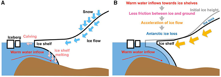
- Figure 1 - (A) As ice forms, it flows toward the ocean.
- The ice that overhangs ocean water is called an ice shelf. When warm ocean water flows under the ice shelf, the ice melts and icebergs can break off. (B) As warm water flows underneath the ice, the ice begins to move across the land faster, causing ice to be lost into the ocean more quickly.
Glaciers and ice shelves are rivers of ice flowing from the land into the ocean. When the ice moves against the rocky surface of the Earth or the seafloor, the land can hold it back and friction slows down and stabilizes the ice flow. However, when warm water flows beneath the ice shelf, the ice shelf thins and the water reduces the friction (Figure 1B). This allows the ice to speed up and move toward the ocean faster, contributing to ice loss and sea-level rise [1]. Since the air is very cold in most regions of Antarctica, almost all ice loss is due to melting that happens in the oceans. So, we need to understand how warm ocean water travels toward the Antarctic ice shelves.
Observations Near The Antarctic Coast Are Difficult
Sea ice is frozen ocean water. Cold air temperatures and strong winds freeze seawater and form large areas of floating sea ice. In summer, some of the sea ice melts. Icebergs are large chunks of ice that break off from glaciers due to calving. Icebergs can be huge. For example, one of the largest icebergs has an area of about 300 km by 40 km!
As you can see from the satellite image in Figure 2A, there are two ice shelves in this region. One is the Totten Ice Shelf (TIS) and the other is the Moscow University Ice Shelf (MUIS). Figures 3A, B give you a close look at the ice-covered regions in Figure 2, in front of the TIS and MUIS, respectively. Huge areas of sea ice cover the ocean surface close to the front of the TIS. Such a large area of sea ice is formed when smaller pieces of sea ice join together and accumulate snow on top of them. Since such a huge plate of sea ice can be 5–10 m thick, there is no chance for exploratory boats called icebreakers to travel into this region.
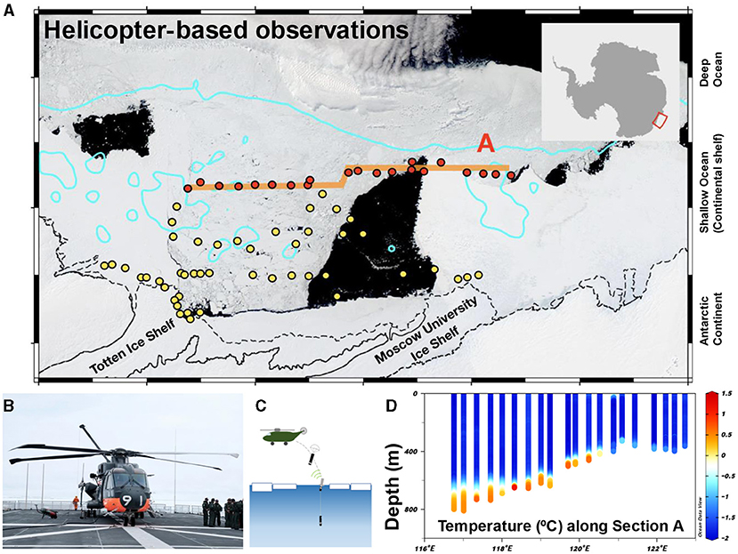
- Figure 2 - (A) Satellite image from December 2019, off the TIS and MUIS.
- Regions in white are sea ice or icebergs. Regions in black are the ocean surface with little sea ice cover. Blue circles show regions where sea ice fully covers the ocean surface and the icebreaker Shirase could not travel. Pink circles show areas where there was little sea ice. (B) Helicopter used for ocean observations. (C) Sensors dropped from helicopters into cracks in the sea ice. (D) Vertical sections of ocean temperature along line A. The red-orange color indicates warm ocean heat pathways toward the TIS.
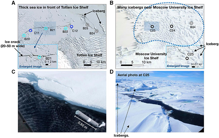
- Figure 3 - (A) Zoomed-in shot of Figure 2A, for the region in front of the TIS.
- You can see TIS, thick sea ice, icebergs, and ice cracks. (B) Zoomed-in shot of Figure 2A, for the area near the MUIS. You can see thick sea ice and icebergs. (C) Aerial photo showing an AXCTD sensor falling into a sea-ice crack. (D) Photo taken from the helicopter showing sea ice, ice crack, and icebergs.
In Figure 3B, you can see the region in front of the MUIS, showing a big difference between the east and the west. In the west, one big piece of sea ice covers the ocean surface. This condition is similar to the TIS. However, in other locations, we find hundreds of huge icebergs—each a few km2 in size and about 300–400 m thick. The aerial photo in Figure 3D shows a few icebergs with heights (from the ocean surface to the top) of about 20–30 m. This means that about 200–300 m of ice is hidden in the seawater.
Our research group took part in the 61st Japanese Antarctic Research Expedition (JARE61). We sailed on the Japanese icebreaker Shirase between December 2019 and March 2020. Icebreakers are designed with hulls strong enough to push sea ice away or break the ice by ramming into it. Icebreakers can easily move forward when sea ice is not thick or does not fully cover the ocean surface. When the sea ice is thick (about 1 or 2 m) and forms a solid sheet, it is difficult for icebreakers to move forward. In the case of the JARE61 expedition, we sometimes spent an entire day trying to move forward in a region with thick ice; sometimes we only moved a few 100 m or less in 24 h. We found very thick sea ice covering most of the ocean surface near the TIS, so Shirase could not make progress there. Thus, the Shirase decided to remain in a nearby area with less sea ice for all of December 2019.
In the past, American, Australian, and Japanese icebreakers attempted to observe larger regions in front of the TIS [2], but they failed because there is usually thick sea ice covering the areas in front of the TIS and MUIS. Therefore, no one could observe what was happening in the ocean in the areas where warm ocean water was likely flowing toward the key ice shelves in this region.
Using Helicopters To Find Heat Pathways
The icebreaker Shirase is equipped with CH-101 helicopters (Figure 2B). We flew from the ship to the target sites and dropped sensors called Airborne eXpendable Conductivity, Temperature, and Depth sensors (AXCTD) and Airborne eXpendable Bathy-Thermograph sensors (AXBT) from the rear door of the helicopter. The sensors are enclosed in a protective case and a small parachute attached to the sensors opens quickly after they are released (Figure 2C). The sensor descends in a controlled manner and lands in the water. At the ocean surface, the sensor is released from the protective case. The system consists of a floating buoy and a sensor, connected to each other by 1,000 m of very thin wire. The sensor sinks to the seafloor, measuring temperature and salinity along the way. The floating buoy transmits the data to the helicopter overhead. Using this method, within 6 days we surveyed temperature, salinity, and ocean depth at 67 stations.
Helicopters can travel faster than ships. They can fly over very thick sea ice and icebergs. They can hover while workers prepare and drop sensors into gaps in the sea ice. Helicopters allowed us to travel to previously unreachable areas and observe the ocean beneath thick sea ice and some icebergs. We could also drop sensors into a 20-m-wide crack in the sea ice off the TIS (Figure 3A) and a 15-m-wide crack surrounded by icebergs and sea ice near the MUIS (Figures 3C, D).
We observed an inflow of warm water traveling toward the TIS (Figure 2D). The inflow is about 150 km wide. We also observed warm water deep in the ocean, at temperatures of about 0.5–1°C. In the salty water of the ocean, the freezing point is about -2°C. Although this sounds cold by non-Antarctic standards, the water is very warm for the ice. Using helicopters, we identified wide pathways of warm water flowing toward the TiS for the first time. This warm water flows in a thin layer only 50–100 m thick. In contrast, previous studies found a thicker layer of warm ocean water flowing toward Antarctic ice shelves in the highest ice shelf-melting region in Antarctica [1]. This finding suggests that, if the warm water inflow we observed thickens, the melting of the TIS might greatly increase.
The Future
Now that we know how warm ocean water is traveling toward the TIS, the next step is to develop a computer model of the ocean in this region, to simulate the warm water inflow [3]. Scientists can use computer models to understand the mechanisms of warm ocean flow and to predict future changes. This information can help policymakers to make decisions about how we can prevent and adapt to climate change and rising sea levels.
Glossary
Ice Shelf: ↑ When a glacier flows into the ocean, it forms a floating extension called an ice shelf.
Iceberg: ↑ A large floating mass of ice detached from a glacier or ice shelf.
Sea Ice: ↑ Frozen seawater.
Icebreaker: ↑ A ship designed to move through waters covered with ice, by breaking through it.
Airborne EXpendable Conductivity, Temperature, and Depth (AXCTD) Sensor: ↑ A sensor that can be dropped to the bottom of the ocean from a helicopter or a plane and can send back information about ocean depth, temperature, and salinity.
Airborne Expendable Bathy-Thermograph (AXBT) Sensor: ↑ Like AXCTD, but it can only send back the ocean depth.
Salinity: ↑ The concentrations of salts in seawater.
Computer Model: ↑ A computer program that is designed to simulate ocean circulation.
Conflict of Interest
The authors declare that the research was conducted in the absence of any commercial or financial relationships that could be construed as a potential conflict of interest.
Acknowledgments
YN acknowledges support from Grants-in-Aids for Scientific Research (21K13989) from the Ministry of Education, Culture, Sports, Science, and Technology in Japan and the Inoue Science Research Award from the Inoue Science Foundation. PW received grant funding from the Australian Government as part of the Antarctic Science Collaboration Initiative Program. JG acknowledges support from NSF grants OPP-2114454 and OPP-2309648, NASA’s Cryosphere Program under grant 80NSSC22K0387, and the G. Unger Vetlesen Foundation.
Original Source Article
↑Nakayama, Y., Wongpan, P., Greenbaum, J. S., Yamazaki, K., Noguchi, T., Simizu, D., et al. 2023. Helicopter-based ocean observations capture broad ocean heat intrusions toward the Totten Ice Shelf. Geophys. Res. Lett. 50:e2022GL097864. doi: 10.1029/2022GL097864
References
[1] ↑ Wåhlin, A. K., Steiger, N., Darelius, E., Assmann, K. M., Glessmer, M. S., and Ha, H. K., et al 2020. Ice front blocking of ocean heat transport to an Antarctic ice shelf. Nature. 578:568–71. doi: 10.1038/s41586-020-2014-5
[2] ↑ Rintoul, S. R., Silvano, A., Pena-Molino, B., van Wijk, E., Rosenberg, M., and Greenbaum, J. S., et al (2016). Ocean heat drives rapid basal melt of the Totten Ice Shelf. Sci. Adv.. 2:e1601610. doi: 10.1126/sciadv.1601610
[3] ↑ Nakayama, Y., Greene, C. A., Paolo, F. S., Mensah, V., Zhang, H., and Kashiwase, H., et al 2021. Antarctic Slope Current modulates ocean heat intrusions towards Totten Glacier. Geophys. Res. Lett. 48:e2021GL094149. doi: 10.1029/2021GL094149